Sugarcane ethanol: Contributions to climate change - BAFF
Sugarcane ethanol: Contributions to climate change - BAFF
Sugarcane ethanol: Contributions to climate change - BAFF

You also want an ePaper? Increase the reach of your titles
YUMPU automatically turns print PDFs into web optimized ePapers that Google loves.
Chapter 3<br />
Another source of data on sugarcane planted area is the National Food Supply Company<br />
(CONAB). CONAB data, which are presented in a crop assessment reports, are not used<br />
in this study.<br />
<strong>Sugarcane</strong> planted area is also provided on the Canasat Project, coordinated by the National<br />
Institute for Space Research (INPE). Canasat Project moni<strong>to</strong>rs the most important producing<br />
states and estimates the planted area from remote sensing satellite images. A summary of<br />
data available in Brazil is presented in the Table 1.<br />
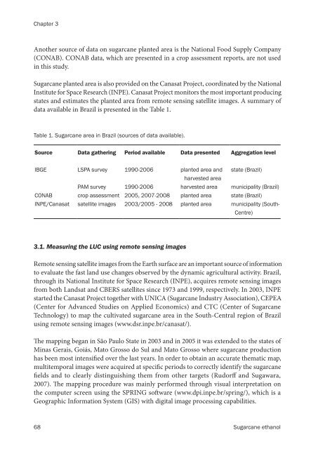
Table 1. <strong>Sugarcane</strong> area in Brazil (sources of data available).<br />
Source Data gathering Period available Data presented Aggregation level<br />
IBGE LSPA survey 1990-2006 planted area and<br />
harvested area<br />
state (Brazil)<br />
PAM survey 1990-2006 harvested area municipality (Brazil)<br />
CONAB crop assessment 2005, 2007-2008 planted area state (Brazil)<br />
INPE/Canasat satellite images 2003/2005 - 2008 planted area municipality (South-<br />
Centre)<br />
3.1. Measuring the LUC using remote sensing images<br />
Remote sensing satellite images from the Earth surface are an important source of information<br />
<strong>to</strong> evaluate the fast land use <strong>change</strong>s observed by the dynamic agricultural activity. Brazil,<br />
through its National Institute for Space Research (INPE), acquires remote sensing images<br />
from both Landsat and CBERS satellites since 1973 and 1999, respectively. In 2003, INPE<br />
started the Canasat Project <strong>to</strong>gether with UNICA (<strong>Sugarcane</strong> Industry Association), CEPEA<br />
(Center for Advanced Studies on Applied Economics) and CTC (Center of <strong>Sugarcane</strong><br />
Technology) <strong>to</strong> map the cultivated sugarcane area in the South-Central region of Brazil<br />
using remote sensing images (www.dsr.inpe.br/canasat/).<br />
�e mapping began in São Paulo State in 2003 and in 2005 it was extended <strong>to</strong> the states of<br />
Minas Gerais, Goiás, Ma<strong>to</strong> Grosso do Sul and Ma<strong>to</strong> Grosso where sugarcane production<br />
has been most intensi�ed over the last years. In order <strong>to</strong> obtain an accurate thematic map,<br />
multitemporal images were acquired at speci�c periods <strong>to</strong> correctly identify the sugarcane<br />
�elds and <strong>to</strong> clearly distinguishing them from other targets (Rudor� and Sugawara,<br />
2007). �e mapping procedure was mainly performed through visual interpretation on<br />
the computer screen using the SPRING so�ware (www.dpi.inpe.br/spring/), which is a<br />
Geographic Information System (GIS) with digital image processing capabilities.<br />
68 <strong>Sugarcane</strong> <strong>ethanol</strong>