Pierre River Mine Project
Pierre River Mine Project
Pierre River Mine Project
- TAGS
- pierre
- river
- project
- www.ceaa.gc.ca

Create successful ePaper yourself
Turn your PDF publications into a flip-book with our unique Google optimized e-Paper software.
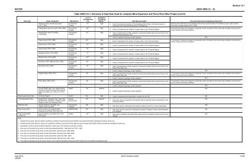
WATER AENV SIRS 15 – 43<br />
Data Type Name of Data Set Data Source<br />
Athabasca <strong>River</strong> at Embarras airport<br />
(1971–1984)<br />
Environment<br />
Canada<br />
Firebag <strong>River</strong> near the mouth (1970–2006) Environment<br />
Canada<br />
Muskeg <strong>River</strong> near Fort McKay<br />
(1974-2006)<br />
Environment<br />
Canada<br />
Poplar Creek (1973–1986) Environment<br />
Canada<br />
Beaver <strong>River</strong> (1975–2006) Environment<br />
Canada<br />
Joslyn Creek (1975–1993) Environment<br />
Canada<br />
Steepbank <strong>River</strong> (1972–2006) Environment<br />
Canada<br />
MacKay <strong>River</strong> (1972–2006) Environment<br />
Canada<br />
Ells <strong>River</strong> (1975–1986 and 2001–2005) Environment<br />
Canada<br />
Big Creek (1975–1993)<br />
Asphalt Creek (1975–1977)<br />
<strong>Pierre</strong> <strong>River</strong> (1975–1977)<br />
Several RAMP data in the Jackpine <strong>Mine</strong><br />
Expansion and <strong>Pierre</strong> <strong>River</strong> <strong>Mine</strong> regional<br />
study area (RSA), see Table 2.2-4 in the<br />
ESR<br />
Environment<br />
Canada<br />
Environment<br />
Canada<br />
Environment<br />
Canada<br />
Table AENV 23-1: Summary of Data Sets Used for Jackpine <strong>Mine</strong> Expansion and <strong>Pierre</strong> <strong>River</strong> <strong>Mine</strong> <strong>Project</strong> (cont'd)<br />
Level of<br />
Completeness<br />
(%)<br />
Qualitative<br />
Confidence<br />
Rating 1, 2 How Data was Used? How was Historical Incompleteness Resolved?<br />
71 4 High • Used to characterize variation of the Athabasca <strong>River</strong> flows in the lower reaches in<br />
conjunction with measured flows below Fort McMurray<br />
80 5 High<br />
81 6 High<br />
100 High<br />
78 6 High<br />
75 7 High<br />
77 6 High<br />
80 6 High<br />
80 7 High<br />
• Used to characterize the variation of water yields in the Oil Sands Region<br />
• Used to characterize monthly, seasonal, annual and extreme flood and low flows for the<br />
Jackpine <strong>Mine</strong> Expansion LSA<br />
Monthly flow relationships with Athabasca <strong>River</strong> flows recorded below Fort McMurray were used to derive<br />
flow data for longer periods (1957–2006)<br />
Section 12.1<br />
If more than 10 days are missing for a particular month, the data for that month was not taken into account to<br />
derive monthly and annual statistics<br />
• Used for regional hydrologic model validation N/A<br />
• Used to characterize the variation of water yields in the Oil Sands Region<br />
• Used to characterize the variation of water yields in the Oil Sands Region<br />
• Used to characterize the variation of water yields in the Oil Sands Region<br />
• Used to characterize the variation of water yields in the Oil Sands Region<br />
• Used to characterize the variation of water yields in the Oil Sands Region<br />
• Used to characterize the variation of water yields in the Oil Sands Region<br />
76 8 High • Used to characterize monthly, seasonal, annual and extreme flood and low flows for the<br />
<strong>Pierre</strong> <strong>River</strong> <strong>Mine</strong> LSA<br />
If more than 10 days are missing for a particular month, the data for that month was not taken into account to<br />
derive monthly and annual statistics<br />
• Used for regional hydrologic model validation N/A<br />
90 High • Used to characterize monthly, seasonal, annual and extreme flood and low flows for the<br />
<strong>Pierre</strong> <strong>River</strong> <strong>Mine</strong> LSA<br />
RAMP 60 9 Medium<br />
If more than 10 days are missing for a particular month, the data for that month was not taken into account to<br />
derive monthly and annual statistics<br />
• Used for regional hydrologic model validation N/A<br />
• Used for regional hydrologic model validation<br />
Stream geomorphic data Oil Sands Region Golder 100 High • Used to characterize the geomorphic condition for the LSA N/A<br />
Total suspended solids Muskeg <strong>River</strong>, Muskeg Creek, Kearl Lake,<br />
MacKay <strong>River</strong>, Ells <strong>River</strong>, Jackpine Creek,<br />
Wapasu Creek and Athabasca <strong>River</strong><br />
Sediment yield Several streams in the RSA, see<br />
Table 2.3-20 in the ESR<br />
Snow survey data Snow survey in the Jackpine <strong>Mine</strong><br />
Expansion and <strong>Pierre</strong> <strong>River</strong> <strong>Mine</strong> LSA<br />
<strong>Project</strong> hydrometric<br />
monitoring<br />
Several stations, see Table 2.2-5 in the<br />
ESR report<br />
Alberta<br />
Environment<br />
Environment<br />
Canada<br />
100 Medium<br />
100 High<br />
• Data were used to characterize the baseline total suspended solids concentration in the<br />
receiving streams<br />
• Data were used to characterize the baseline sediment yield from various watersheds<br />
RAMP/Golder 100 High • Data were used to support the Hydrologic Simulation Program Fortran model calibration<br />
and validation<br />
Golder 50 8 High • Data used to establish site-specific flow data and also to establish rating curves for local<br />
streams<br />
Note:<br />
1. All data that has been rated as high for qualitative confidence assumed that several QA/QC were performed before releasing the data for public use.<br />
2. All data that has been rated as medium for qualitative confidence assumed that the data has gone through basic QA/QC before the data was released for public use.<br />
3. Precipitation at Ells Lookout and Birch Mountain Lookout were only measured during the summer.<br />
4. Flow was not recorded during winter months (November/December – Mar/April) from 1977–1984.<br />
5. Flow was not recorded during winter months (November–February) from 1984–2006.<br />
6. Flow was not recorded during winter months (November–February) from 1987–2006.<br />
7. Flow was not recorded during winter months (November–April) from 2001–2005.<br />
8. Flow was not recorded during winter months (November–February) from 1981–1993.<br />
9. Two stations operating during the winter months, seven stations operating during open-water season and nine stations operating all year.<br />
April 2010 Shell Canada Limited 12-29<br />
CR029<br />
N/A<br />
N/A<br />
N/A<br />
N/A<br />
N/A