

Fourth Study Conference on BALTEX Scala Cinema Gudhjem
Fourth Study Conference on BALTEX Scala Cinema Gudhjem
Fourth Study Conference on BALTEX Scala Cinema Gudhjem

You also want an ePaper? Increase the reach of your titles
YUMPU automatically turns print PDFs into web optimized ePapers that Google loves.
- 156 -<br />
Classificati<strong>on</strong> of Precipitati<strong>on</strong> Type and its Diurnal Cycle in REMO<br />
Simulati<strong>on</strong> and in Observati<strong>on</strong>s<br />
Andi Walther 1 , Ralf Bennartz 1, 2 , Daniela Jacob 3 and Jürgen Fischer 1<br />
1<br />
Institut für Weltraumwissenschaften, Freie Universität Berlin,Carl-Heinrich-Beckerweg 6-10, D-12165 Berlin, Germany<br />
2<br />
Atmospheric & Oceanic Sciences, University of Wisc<strong>on</strong>sin, Madis<strong>on</strong>, WI<br />
3<br />
Max Planck Institut für Meteorologie, Hamburg, Germany<br />
E-mail: andi.walther@wew.fu-berlin.de<br />
1. Introducti<strong>on</strong><br />
The overall objective of the BALTIMOS project is the<br />
development of a coupled model system for the Baltic Sea<br />
and its catchment basin in order to understand and model<br />
exchange processes between atmosphere, sea, land surface,<br />
and lakes including hydrology. BALTIMOS is a<br />
c<strong>on</strong>tributi<strong>on</strong> to the BMBF research program DEKLIM.<br />
Observati<strong>on</strong>s and modeling of spatial and temporal<br />
variability of precipitati<strong>on</strong> are an important factor for<br />
understanding the water cycle. Sumner (1988) classifies<br />
precipitati<strong>on</strong> as an expressi<strong>on</strong> of origin and c<strong>on</strong>sidered three<br />
main types: c<strong>on</strong>vecti<strong>on</strong>al, cycl<strong>on</strong>ic and orographic. One<br />
focal point of this presentati<strong>on</strong> is the applicati<strong>on</strong> of a method<br />
to divide precipitati<strong>on</strong> in fr<strong>on</strong>tal and n<strong>on</strong>-fr<strong>on</strong>tal fracti<strong>on</strong>.<br />
Models simulate the diurnal cycle of precipitati<strong>on</strong> often<br />
wr<strong>on</strong>gly. Operati<strong>on</strong>al models tend to produce the maximum<br />
of precipitati<strong>on</strong> over land at about local no<strong>on</strong>, corresp<strong>on</strong>ding<br />
to the time of maximum heating (Trenberth et al. 2003).<br />
Observati<strong>on</strong>s have shown that this timing is a few hours<br />
before. One further goal of this study is to compare the<br />
diurnal cycle of REMO simulati<strong>on</strong>s with observati<strong>on</strong>s from<br />
radar data.<br />
2. Regi<strong>on</strong>al model REMO<br />
The regi<strong>on</strong>al climate model REMO that will be used in this<br />
study is developed by the Max Planck Institut for<br />
Meteorology (MPI) in Hamburg (e.g. Jacob and<br />
Claussen,M.. (1995)). It is a three-dimensi<strong>on</strong>al, hydrostatic<br />
atmosphere model, that is based <strong>on</strong> the DWD physical<br />
parameterizati<strong>on</strong> model. The horiz<strong>on</strong>tal resoluti<strong>on</strong> is 1/6° or<br />
in a grid size equal of about 18 x 18 km². Our investigati<strong>on</strong>s<br />
were processed in the “climate” modus.<br />
3. Radar Data Source<br />
The primary data used in our study are the BALTRAD<br />
composite radar reflectivity data set. The properties of this<br />
product include 2 km spatial grid with 15 minutes temporal<br />
resoluti<strong>on</strong> and 8-bit dBZ c<strong>on</strong>verter. The BALTRAD data are<br />
gauge-adjusted and can be transformed into rain intensity<br />
informati<strong>on</strong> with two fixed seas<strong>on</strong>al-dependent Z-R<br />
relati<strong>on</strong>s. This procedure was undertaken by the Swedish<br />
Weather service (SMHI) and introduced by Michels<strong>on</strong> et al.<br />
(1999).<br />
In order to compare with REMO output it was necessary to<br />
transform the data from a 2 km spatial grid into REMO grid<br />
(1/6 ° - about 18 km spatial resoluti<strong>on</strong>). The rain rates of all<br />
BRDC-pixel, rain or n<strong>on</strong>-rain pixel inside a REMO pixel are<br />
averaged.<br />
4. Fr<strong>on</strong>tal/N<strong>on</strong>-fr<strong>on</strong>tal Distincti<strong>on</strong><br />
The main attribute is to classify c<strong>on</strong>tiguous precipitati<strong>on</strong><br />
systems in c<strong>on</strong>trast to classificati<strong>on</strong> of each individual pixel<br />
in other investigati<strong>on</strong>s (e.g. Steiner et al. (1995)). That<br />
means, that each pixel of a c<strong>on</strong>tiguous rain area gets a<br />
comm<strong>on</strong> classificati<strong>on</strong>, fr<strong>on</strong>tal or n<strong>on</strong>-fr<strong>on</strong>tal. Threshold for<br />
rain pixel was defined as 0.2 mm/hr. Any rain areas<br />
smaller than 4,000 km² are initially c<strong>on</strong>sidered, by virtue<br />
of their space scale, to be n<strong>on</strong>-fr<strong>on</strong>tal. Larger echoes are<br />
subject of a classificati<strong>on</strong> algorithm with help of an<br />
artificial neural network (ANN) algorithm. Input<br />
parameters of the ANN are 9 texture and shape<br />
informati<strong>on</strong>. Texture informati<strong>on</strong> is a result of statistical<br />
analysis of spatial rain rate differences and gives a hint of<br />
homogeneity and the inner structure of the rain field.<br />
Shape parameters are the size of the major axis, the<br />
eccentricity and the size of the area. 400 scenes from the<br />
available dataset of BALTRAD network were randomly<br />
selected to classify manually with help by weather<br />
reanalysis maps. Both, the calculated parameters of a rain<br />
area, and the corresp<strong>on</strong>ding classificati<strong>on</strong> represent <strong>on</strong>e<br />
vector of the training dataset of the ANN.<br />
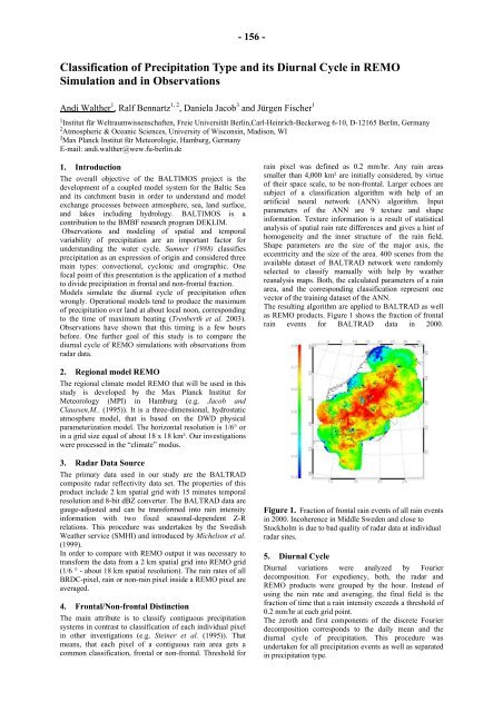
The resulting algorithm are applied to BALTRAD as well<br />
as REMO products. Figure 1 shows the fracti<strong>on</strong> of fr<strong>on</strong>tal<br />
rain events for BALTRAD data in 2000.<br />
Figure 1. Fracti<strong>on</strong> of fr<strong>on</strong>tal rain events of all rain events<br />
in 2000. Incoherence in Middle Sweden and close to<br />
Stockholm is due to bad quality of radar data at individual<br />
radar sites.<br />
5. Diurnal Cycle<br />
Diurnal variati<strong>on</strong>s were analyzed by Fourier<br />
decompositi<strong>on</strong>. For expediency, both, the radar and<br />
REMO products were grouped by the hour. Instead of<br />
using the rain rate and averaging, the final field is the<br />
fracti<strong>on</strong> of time that a rain intensity exceeds a threshold of<br />
0.2 mm/hr at each grid point.<br />
The zeroth and first comp<strong>on</strong>ents of the discrete Fourier<br />
decompositi<strong>on</strong> corresp<strong>on</strong>ds to the daily mean and the<br />
diurnal cycle of precipitati<strong>on</strong>. This procedure was<br />
undertaken for all precipitati<strong>on</strong> events as well as separated<br />
in precipitati<strong>on</strong> type.


