

Fourth Study Conference on BALTEX Scala Cinema Gudhjem
Fourth Study Conference on BALTEX Scala Cinema Gudhjem
Fourth Study Conference on BALTEX Scala Cinema Gudhjem

Create successful ePaper yourself
Turn your PDF publications into a flip-book with our unique Google optimized e-Paper software.
- 35 -<br />
EVA-GRIPS: Regi<strong>on</strong>al Evaporati<strong>on</strong> at Grid and Pixel Scale over<br />
Heterogeneous Land Surfaces<br />
Heinz-Theo Mengelkamp and the EVA-GRIPS Team<br />
GKSS Research Center, D-21502 Geesthacht, Germany, (mengelkamp@gkss.de)<br />
1. Introducti<strong>on</strong><br />
The determinati<strong>on</strong> of the area-averaged evaporati<strong>on</strong> and<br />
sensible heat flux over a heterogeneous land surface is<br />
fundamental for the simulati<strong>on</strong> of the regi<strong>on</strong>al energy and<br />
water budget. This is also the major issue of<br />
EVA_GRIPS. EVA-GRIPS is funded under cluster 3<br />
“Regi<strong>on</strong>al Process Studies in the Baltic Sea Area<br />
(<strong>BALTEX</strong>)” of the Climate Research Programme<br />
(DEKLIM) of the German Federal Ministry of Educati<strong>on</strong><br />
and Research. Through a combinati<strong>on</strong> of near-surface and<br />
boundary layer observati<strong>on</strong>s, the analysis of satellite data<br />
and numerical simulati<strong>on</strong>s EVA-GRIPS aims at testing<br />
and implementing c<strong>on</strong>cepts for the descripti<strong>on</strong> of areaaveraged<br />
turbulent fluxes in land surface schemes. The<br />
spatial scale c<strong>on</strong>sidered in EVA-GRIPS corresp<strong>on</strong>ds to<br />
the grid scale of a regi<strong>on</strong>al atmospheric NWP or climate<br />
model (here in particular the "Lokal-Modell", LM, of the<br />
Deutscher Wetterdienst, DWD, and the model REMO of<br />
the BALTIMOS group), but also to the pixel scale of<br />
currently available satellite images.<br />
Experiment and modelling activities focus <strong>on</strong> an area of<br />
roughly 20 x 20 km 2 around the Meteorological<br />
Observatory Lindenberg (MOL) of DWD. The<br />
c<strong>on</strong>tinuous measurement program of the MOL as a CEOP<br />
reference site formed the basis for a major field<br />
experiment in May and June, 2003.<br />
Eddy correlati<strong>on</strong> instruments were placed at 13 sites over<br />
different land use types and vertical profiles in the<br />
boundary layer were sampled by lidar and radar. A set of<br />
scintillometers, a helicopter borne turbulence probe<br />
HELIPOD and an infrared camera for surface<br />
photography <strong>on</strong> board a Tornado aircraft as well as<br />
satellite images completed the set of instruments. The<br />
spatial sampling and footprint scales of this suite of<br />
measurement systems covered five orders of magnitude<br />
(10 -1 .. 10 4 m for the sampling scale) and three orders of<br />
magnitude (10 1 .. 10 4 m for the footprint scale),<br />
respectively.<br />
2. Some Results<br />
Pr<strong>on</strong>ounced differences in surface characteristics (e.g.<br />
surface temperature) can be found over the different types<br />
of land use in the experimental area.<br />
These differences in land use and surface characteristics<br />
result in significant evaporati<strong>on</strong> differences both in<br />
numerical models and estimates from satellite data<br />
(Figure 2). The intercomparis<strong>on</strong> of LM results and<br />
NOAA images reveals differences in magnitude of the<br />
evaporati<strong>on</strong> and its spatial patterns due to surface<br />
heterogeneity.<br />
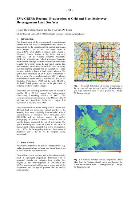
Fig. 1: Regi<strong>on</strong>al distributi<strong>on</strong> of surface temperature in<br />
the experimental area measured by the Helipod during a<br />
grid flight pattern <strong>on</strong> June 17, 2003 (picture by J. Bange,<br />
TU Braunschweig)<br />
Fig. 2: Calibrated infrared surface temperature. Photo<br />
taken from the Tornado aircraft over a small part of the<br />
experimental area <strong>on</strong> June 17, 2003 (picture by J. Bange,<br />
TU Braunschweig)


