

Fourth Study Conference on BALTEX Scala Cinema Gudhjem
Fourth Study Conference on BALTEX Scala Cinema Gudhjem
Fourth Study Conference on BALTEX Scala Cinema Gudhjem

Create successful ePaper yourself
Turn your PDF publications into a flip-book with our unique Google optimized e-Paper software.
-39-<br />
Calibrated Surface Temperature Maps of Heterogeneous Terrain Derived<br />
from Helipod and German Air Force Tornado Flights during LITFASS-<br />
2003<br />
Jens Bange, Stephan Wilken, Thomas Spieß, and Peter Zittel<br />
Aerospace Systems, TU Braunschweig, Hermann-Blenk-Str. 23, 38108 Braunschweig - Germany. E-Mail: j.bange@tu-bs.de<br />
1. Introducti<strong>on</strong><br />
Complementary to the ground-based measurement systems,<br />
the remote sensing, and the numerical models in the<br />
LITFASS-2003 field experiment, two air-borne systems<br />
were employed: The helicopter-borne turbulence probe<br />
Helipod (Fig. 1; e.g. Bange and Roth 1999, Bange et al.<br />
2002) of the Technical University of Braunschweig and<br />
Tornado aircraft (Fig. 2) of the 51 th Rec<strong>on</strong>. Sqr. of the<br />
German Air Force.<br />
Fig. 1: The helicopter-borne turbulence probe Helipod.<br />
Fig. 2: A German Air Force RECCE Tornado.<br />
The Tornado aircraft were equipped with a line-scanning<br />
infra-red (IR) camera that provided high-c<strong>on</strong>trast images of<br />
the surface temperature variati<strong>on</strong>s. These images were<br />
calibrated using absolute surface temperature measurements<br />
performed with the Helipod. It is expected that the resulting<br />
high-resoluti<strong>on</strong> temperature maps will help with the<br />
initializati<strong>on</strong> and verificati<strong>on</strong> of numerical models of the<br />
atmosphere, especially with the parameterizati<strong>on</strong> and<br />
initializati<strong>on</strong> of Large Eddy Simulati<strong>on</strong>s (LES): The surface<br />
temperature together with an estimati<strong>on</strong> of the surface<br />
roughness may offer a reas<strong>on</strong>able alternate to pre-defined<br />
turbulent surface fluxes.<br />
2. Experimental Set-Up and Strategy<br />
The LITFASS experimental site is characterized by<br />
heterogeneity <strong>on</strong> nearly every length scale (Fig. 3) which<br />
is quite characteristic for areas within the BALTIC regi<strong>on</strong>.<br />
This distinct heterogeneity makes it difficult to define<br />
area-averaged turbulent fluxes or representative sub-scale<br />
parameterizati<strong>on</strong>s for numerical models.<br />
Fig. 3: Land-use of the experimental site in 2003.<br />
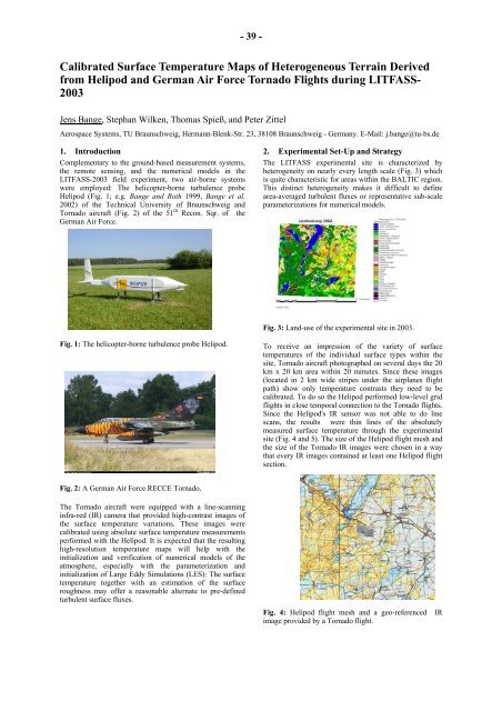
To receive an impressi<strong>on</strong> of the variety of surface<br />
temperatures of the individual surface types within the<br />
site, Tornado aircraft photographed <strong>on</strong> several days the 20<br />
km x 20 km area within 20 minutes. Since these images<br />
(located in 2 km wide stripes under the airplanes flight<br />
path) show <strong>on</strong>ly temperature c<strong>on</strong>trasts they need to be<br />
calibrated. To do so the Helipod performed low-level grid<br />
flights in close temporal c<strong>on</strong>necti<strong>on</strong> to the Tornado flights.<br />
Since the Helipod's IR sensor was not able to do line<br />
scans, the results were thin lines of the absolutely<br />
measured surface temperature through the experimental<br />
site (Fig. 4 and 5). The size of the Helipod flight mesh and<br />
the size of the Tornado IR images were chosen in a way<br />
that every IR images c<strong>on</strong>tained at least <strong>on</strong>e Helipod flight<br />
secti<strong>on</strong>.<br />
Fig. 4: Helipod flight mesh and a geo-referenced IR<br />
image provided by a Tornado flight.


