- Page 1 and 2: O Nordeste e as Lavouras Xerófilas
- Page 3 and 4: Obra Publicado pelo Presidente: Rob
- Page 5 and 6: 5 - QUESTÕES DE CULTIVO SECO .....
- Page 8 and 9: 1 - EVOLUÇÃO E MENTALIDADE Na evo
- Page 10 and 11: A desproporção dos conhecimentos
- Page 12 and 13: Pelo nosso atraso, não podemos cul
- Page 14: cimento. Não é somente o método
- Page 17 and 18: chegaremos à conclusão de que é
- Page 19 and 20: 18 Paraíba - Município de Souza -
- Page 21 and 22: Mata - Cruz das Almas-Bahia (1950-5
- Page 23 and 24: Umidade relativa, anual, mínima ..
- Page 25 and 26: Caatinga - Propriá - Sergipe - Obs
- Page 27 and 28: Agreste - Pesqueira - Pernambuco. O
- Page 29 and 30: Mata - Cruz das Almas - Bahia. Obse
- Page 31 and 32: 30 M A T A CAATINGA SERIDÓ ? CARRA
- Page 33 and 34: capim-mimoso (Anthephora hermaphrod
- Page 35: veleira transpira o máximo ao meio
- Page 39 and 40: 38 Xerofilismo. Mudinha de faveleir
- Page 41 and 42: conhecimentos, de cooperar, de ajud
- Page 43 and 44: desde o tempo em que dirigiu a Sec
- Page 45 and 46: Não temos ainda estações meteoro
- Page 47 and 48: Mata Agreste 1. Pimenteira.........
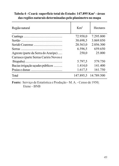
- Page 49: 18. Nazaré .......................
- Page 53 and 54: 17. Fortaleza .....................
- Page 55 and 56: Tabela 7 - Rio Grande do Norte: sup
- Page 57 and 58: 16. Almino Afonso .................
- Page 59 and 60: 58 Tabela 10 - Paraíba: superfíci
- Page 61 and 62: Tabela 11 - Paraíba: regiões natu
- Page 63 and 64: Regiões naturais 62 Região Serid
- Page 65 and 66: Tabela 14 - Pernambuco: regiões na
- Page 67 and 68: Tabela 14 - Pernambuco: regiões na
- Page 69 and 70: Tabela 17 - Alagoas: regiões natur
- Page 71 and 72: Regiões naturais 70 Região Tabela
- Page 73 and 74: Tabela 20 - Sergipe: regiões natur
- Page 75 and 76: Tabela 23 - Bahia: regiões naturai
- Page 77 and 78: Agreste 1. Amargosa ...............
- Page 79 and 80: 12. Chorrochó ....................
- Page 81 and 82: 80 3.1 - Seridó A região se carac
- Page 83 and 84: Os municípios total ou parcialment
- Page 85 and 86: Os minérios de chelita, tantalita,
- Page 87 and 88: 3.300 2.900 2.500 2.100 66 64 62 60
- Page 89 and 90: dezembro-janeiro, atinge a 37°C. N
- Page 91 and 92: Estados R. G. do Norte....... Cear
- Page 93 and 94: 92 1) Interessar os homens esclarec
- Page 95 and 96: Altitude de Paulistana.............
- Page 97 and 98: 96 Foto 3 - Vista do sertão cearen
- Page 99 and 100: Tabela 26 - Regiões naturais com a
- Page 101 and 102:
Tabela 26 - Regiões naturais com a
- Page 103 and 104:
REGIÕES NATURAIS ESTIMATIVA a) Ade
- Page 105 and 106:
asteira, que cobre o chão da caati
- Page 107 and 108:
São João do Piauí. A lagoa de Na
- Page 109 and 110:
A produção de mandioca, de frutas
- Page 111 and 112:
Pelo esquema de Hans Singer, nessa
- Page 113 and 114:
8) Dividir os pastos grandes em men
- Page 115 and 116:
A caatinga baiana é povoada de cac
- Page 117 and 118:
3.300 2.900 2.500 81 77 73 34 30 26
- Page 119 and 120:
118 Desvios da chuva, em mm. em rel
- Page 121 and 122:
120 Foto 4 - Trecho da caatinga do
- Page 123 and 124:
122 Foto 6 - Caatinga pernambucana,
- Page 125 and 126:
124 Os meses mais chuvosos são os
- Page 127 and 128:
Quando o fazendeiro quer trabalho r
- Page 129 and 130:
Precipitações mensais, em mms. 12
- Page 131 and 132:
130 Desvio das chuvas em mms. em re
- Page 133 and 134:
A geologia da zona é mista; aparec
- Page 135 and 136:
duras, coriáceas. A vegetação co
- Page 137 and 138:
A criação do gado no carrasco é
- Page 139 and 140:
138 3.7 - Cerrado A região oeste d
- Page 141 and 142:
endida, com base na experimentaçã
- Page 143 and 144:
Barras, Batalha, Beneditinos, Cocal
- Page 145 and 146:
a colonização mista nipo-brasilei
- Page 147 and 148:
As simples providências, dentro da
- Page 149 and 150:
Milímetros de chuva 148 Altitude d
- Page 151 and 152:
150 Milímetros de chuva ANOS +1.30
- Page 153 and 154:
152 Foto 12 - Região do agreste, P
- Page 155 and 156:
ta Rosa-Picuí) e o seridó (Currai
- Page 157 and 158:
ma, Lagedo, Palmeirinha, Poção, T
- Page 159 and 160:
Foto 15 - Cultura de cafeeiro sombr
- Page 161 and 162:
de, conforme aconteceu com a abertu
- Page 163 and 164:
A mata de Pernambuco e a região da
- Page 165 and 166:
Amaro, S. Félix, S. Filipe, S. F.
- Page 167 and 168:
166 Chuva média anual ............
- Page 169 and 170:
168
- Page 171 and 172:
trabalho, verificamos que 324 milh
- Page 173 and 174:
pregarem mais gente nos afazeres da
- Page 175 and 176:
174
- Page 177 and 178:
pode descuidar de um à vista do ou
- Page 179 and 180:
que ficam faixas de capins e legumi
- Page 181 and 182:
dade guardada a 60cm de profundidad
- Page 183 and 184:
A prática da palhagem, no Congo, n
- Page 185 and 186:
As questões das ervas, dos adubos
- Page 187 and 188:
7) Dispersão da enxurrada para inf
- Page 189 and 190:
188 5.1 - Algodão Mocó Dizem os h
- Page 191 and 192:
contrar a umidade de que necessita,
- Page 193 and 194:
Não discutiremos a seleção indiv
- Page 195 and 196:
forma de agricultura originada de i
- Page 197 and 198:
“A aração e mesmo o gradeamento
- Page 199 and 200:
“Esse método está sendo usado c
- Page 201 and 202:
Esse processo é mais caro e adotad
- Page 203 and 204:
dos períodos anteriores, variou de
- Page 205 and 206:
204 Tabela 39 - Estatística do Alg
- Page 207 and 208:
206 Área cultivada em mil hectares
- Page 209 and 210:
208 Tabela 44 - Algodão em caroço
- Page 211 and 212:
210 Tabela 46 - Algodçao em caroç
- Page 213 and 214:
212 Tabela 48 - Algodão arbóreo C
- Page 215 and 216:
214 Tabela 49 - Algodão arbóreo R
- Page 217 and 218:
216 Tabela 51 - Algodão arbóreo B
- Page 219 and 220:
218 5. 2 - Cultura da carnaubeira L
- Page 221 and 222:
a e, para eliminar o cauncho, são
- Page 223 and 224:
cera, empresta-a ao rendeiro para r
- Page 225 and 226:
es que tem contribuído para o pequ
- Page 227 and 228:
a essas ceras e o instituto de óle
- Page 229 and 230:
Anos 1934 1935 1936 1937 1938 1939
- Page 231 and 232:
Valor da cera exportada em milhões
- Page 233 and 234:
Foto 21 - Carnaubeiras nativas. Fot
- Page 235 and 236:
da Ibiapaba, montou uma pequena fá
- Page 237 and 238:
Características do óleo (36) - O
- Page 239 and 240:
Índice de saponificação ........
- Page 241 and 242:
mento e escavação, para tirar os
- Page 243 and 244:
A torta da semente da oiticica, dep
- Page 245 and 246:
destruição dos frutos. Se não ho
- Page 247 and 248:
Tabela 60 - Produção (x) e export
- Page 249 and 250:
248 Estados Tabela 61 - Produção
- Page 251 and 252:
250 Foto 23 - Pomar de oiticica enx
- Page 253 and 254:
252 5.4 - O Cajueiro Primeiramente
- Page 255 and 256:
mais produtivos. A investigação d
- Page 257 and 258:
Um hectare, com 154 cajueiros, com
- Page 259 and 260:
Foto 26 - Pomar de cajueiros, em so
- Page 261 and 262:
260 Foto - 30 - Coleção de cajus
- Page 263 and 264:
Cultura - Atualmente, os fazendeiro
- Page 265 and 266:
2) Antônio Figueredo - Fazenda Nov
- Page 267 and 268:
Tratos culturais no 1 o ano .......
- Page 269 and 270:
Chuvas médias, mensais, mms. 268 1
- Page 271 and 272:
270 5.6 - A cultura da goiabeira Na
- Page 273 and 274:
do caule, pelo gorgulho da goiaba,
- Page 275 and 276:
274 5.7 - Maniçoba Habitat - Entre
- Page 277 and 278:
novembro e dezembro para a germina
- Page 279 and 280:
278 Tabela 63 - Exportação de bor
- Page 281 and 282:
ácido, etc., que nutrem o vegetal,
- Page 283 and 284:
entrevista ao “Correio da Manhã
- Page 285 and 286:
284 Foto 35 - Ramos, folhas e flore
- Page 287 and 288:
Umidade ...........................
- Page 289 and 290:
dois anos. Assim, ficarão formados
- Page 291 and 292:
290 5.10 - O faveleiro ou favela Ec
- Page 293 and 294:
Composição - O faveleiro é uma
- Page 295 and 296:
“Os dados acima, registrados atra
- Page 297 and 298:
296 Foto 38 - Bosque de faveleiros
- Page 299 and 300:
298 1) Não aumentar os Impostos; 2
- Page 301 and 302:
Os baianos informam que, quando se
- Page 303 and 304:
Foto 42 - Cacho de coquilhos do lic
- Page 305 and 306:
304 Notas 1, 2, 3 - Écologie Vég
- Page 307 and 308:
48 - Manual of Tropical and Subtrop
- Page 309 and 310:
27 - Algodão mocó - Engenheiro-ag
- Page 311 and 312:
310
- Page 313 and 314:
312 Tabela 2 - Produção de Algod
- Page 315 and 316:
314 MMICRORREGIÕES ICRO-REGI ÕES
- Page 317 and 318:
316 MICRORREGIÕES Área (ha) Quant
- Page 319 and 320:
318 Araripin a ( 101) 40. 135 10. 7
- Page 321 and 322:
320 Tabela 11 - Nordeste Produção
- Page 323 and 324:
322 Tabela 13 - Produção e Export
- Page 325 and 326:
324 ANOS Fonte: Etea - M.A. Tabela
- Page 327 and 328:
326 Tabela 17 - Estados Nordestinos
- Page 329 and 330:
328 Tabela 19 - Nordeste Produção
- Page 331:
978.85.87062.36.9 9 788587 062369 C