Plains Indian Studies - Smithsonian Institution Libraries
Plains Indian Studies - Smithsonian Institution Libraries
Plains Indian Studies - Smithsonian Institution Libraries

You also want an ePaper? Increase the reach of your titles
YUMPU automatically turns print PDFs into web optimized ePapers that Google loves.
124 SMITHSONIAN CONTRIBUTIONS TO ANTHROPOLOGY<br />
Hill River. However, there are indications that in<br />
the 1680s some Wichita were still in that most<br />
northern region of old Quivira. Robert Cavelier<br />
de La Salle owned two <strong>Indian</strong> slaves in 1683, a<br />
boy called a Pana who was probably a Wichita<br />
(M. Wedel, 1973:212-213), and a Paneassa<br />
woman presumably of another Wichita band.<br />
The boy's people were said to live in two villages,<br />
which, from the paraphrased description, could<br />
refer to a location on the Smoky Hill. The 1684<br />
Carte de la Louisiane, drawn by Jean-Baptiste Louis<br />
Franquelin (in Thwaites, 1896-1901 (63): frontispiece),<br />
using data provided by La Salle, records<br />
"10 Villages" oi Paneassa, but in such a generalized<br />
way that it is unclear if these hamlets were<br />
near the Smoky Hill or farther south. After 1699,<br />
maps based on secondary information were still<br />
portraying Wichita as living in scattered hamlets<br />
just northeast of the Great Bend, but also in<br />
villages farther south along the Arkansas, usually<br />
on its left hand side, occasionally on the right.<br />
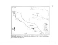
A good case can be made for Benard de La<br />
Harpe finding the 1719 village of the touacaro (the<br />
1541 teucarea) on a terrace today called Wealaka<br />
Ridge (1718-1720, folio 19), near Leonard, Oklahoma.<br />
It is on the south side of the Arkansas<br />
River below present-day Tulsa. This results from<br />
an on-the-ground tracing of the route taken by<br />
La Harpe when he went northwest from his Red<br />
River post (M. Wedel, 1978:14-15) to meet at the<br />
Tawakoni village with Wichita and other Caddoan<br />
groups. The retracing of his course was<br />
made in 1972 (M. Wedel, in prep.) by myself,<br />
Waldo R. Wedel, Larry Banks of the U.S. Army<br />
Corps of Engineers, Dallas, and for a short distance<br />
by Quintus Herron of the Museum of the<br />
Red River.<br />
Dutisne, in his turn, went to one of two villages<br />
about 2.5 to 3 miles (1.5 to 1.9 km) apart. Following<br />
his route description, one is led from an Osage<br />
village on Osage River to a location near the<br />
Verdigris River (W. Wedel, 1959:533; M. Wedel,<br />
1972-1973:155-156) in the vicinity of today's<br />
Neodesha, Kansas. I have elsewhere proposed<br />
(1981:31-32) that the inhabitants of these villages<br />
may have been Taovayas, i.e., Tawehash Wichita.<br />
Dutisne used for them only the imprecise terms<br />
panis, pants, and paniouassa, thus signifying Wichita<br />
but no more.<br />
Benard de La Harpe named the Toayas (the<br />
1541 to^a.y),orTawehash, in his 1118-1720Journal<br />
(folio 19) but provided no settlement location for<br />
them. In the Journal Historique written a few years<br />
later (in Boimare, 1831:208), he stated that they<br />
lived forty leagues north of the touacaro, which<br />
could refer to the Neodesha locality.<br />
He was told (1718-1720, folio 20) that the<br />
Wichita proper (first noted in 1718 on a Guillaume<br />
Delisle map) and Yscanis were living "60<br />
leagues north-northwest" of the touacaro. This may<br />
refer to the Deer Creek tributary region, Kay<br />
County, Oklahoma, where archeological remains<br />
similar to those of the Quiviran Great Bend Aspect<br />
occur, or to a locality farther upstream,<br />
nearer Walnut River, for instance. No home locality<br />
is given in the same Journal (folio 19) for<br />
the adeco or honecha, who apparently comprised<br />
other Wichita bands. The daily journal, the 1720<br />
La Harpe-Gavengeau map (M. Wedel 1981, fig.<br />
10), and the Journal Historique produced in the<br />
1720s considered together reflect understandable<br />
confusion on La Harpe's part as to exactly where<br />
the unvisited Wichita settlements were to be<br />
found.<br />
Reasons for the southward move out of Quivira<br />
are unexplained. Perhaps an answer is to be found<br />
in an examination of Wichita relationships with<br />
their neighbors. For instance, some of the Pawnee<br />
to the north were now looked upon as enemies by<br />
the Wichita. It was the Skiri who in the 1670s<br />
had first captured La Salle's Pana slave (M.<br />
Wedel, 1973:204). A friendly alliance still existed<br />
with others, possibly those later known as South<br />
Bands. The Missouri were termed enemies.<br />
"Seven important villages" of the Arikara were<br />
remarked upon by the Wichita, but the basis for<br />
this knowledge was unrecorded. Relations with<br />
the Osage were described in Benard de La<br />
Harpe's 1718-1720 journal as hostile, but in the<br />
Journal Historique (Boimare, 1831:208) as cautiously<br />
friendly. The accuracy of the latter view<br />
is born out by the Osage who dared to enter a<br />
Wichita village at night to warn of Dutisne's<br />
approach and by the presence of a Mento (Wich-