Plains Indian Studies - Smithsonian Institution Libraries
Plains Indian Studies - Smithsonian Institution Libraries
Plains Indian Studies - Smithsonian Institution Libraries

You also want an ePaper? Increase the reach of your titles
YUMPU automatically turns print PDFs into web optimized ePapers that Google loves.
174 SMITHSONIAN CONTRIBUTIONS TO ANTHROPOLOGY<br />
the Missouri River valley in northeastern Kansas,<br />
northwestern Missouri, southwestern Iowa, and<br />
eastern Nebraska. The Upper Republican phase<br />
is centered around the Republican River in<br />
south-central Nebraska and north-central Kansas<br />
(Figure 28). Other defined units include: St. Helena,<br />
situated in northeastern Nebraska; the Loup<br />
River phase, located along the Loup River in<br />
central Nebraska; and Smoky Hill, centered in<br />
the lower Smoky Hill-Kansas River drainage.<br />
The relationships between the Nebraska and<br />
Upper Republican variants have been considered<br />
by many researchers working with materials from<br />
the sites (Anderson, 1961:73-74; Brown, 1967:43-<br />
53; Gilmore and Bell, 1936:301-355; Hill and<br />
Cooper, 1938:350-353; Strong, 1935:266-267;<br />
Wedel, 1940:310-316; Wood, 1969:97-111). In a<br />
summary statement. Brown (1967:49) pointed<br />
out that "traditionally, sites of the Nebraska and<br />
Upper Republican phases have been regarded as<br />
exhibiting similar house types and non-ceramic<br />
artifacts, and differing ceramic traits."<br />
The ceramic assemblages from the Nebraska<br />
phase were described by Gunnerson (1952), who<br />
divided them into two ware groups defined by<br />
rim form, decoration, and vessel shape. Additional<br />
minor ware groups and the presence of<br />
shell tempering were also noted. The typology<br />
developed by Gunnerson has been applied to<br />
both the Nebraska and Upper Republican variants.<br />
The preference for a type of pottery within<br />
each variant is measured in percentages, since the<br />
ware groups are represented in both phases. Coupled<br />
with the presence or absence of other artifact<br />
types, this preference denotes important regional<br />
variants, but does not mitigate the overwhelming<br />
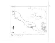
FIGURE 28.—Major archeological units (shaded areas) of the Central <strong>Plains</strong> tradition in<br />
relation to the Glenwood locality (Roper, 1976:182)