Plains Indian Studies - Smithsonian Institution Libraries
Plains Indian Studies - Smithsonian Institution Libraries
Plains Indian Studies - Smithsonian Institution Libraries

Create successful ePaper yourself
Turn your PDF publications into a flip-book with our unique Google optimized e-Paper software.
NUMBER 30 177<br />
N<br />
SELECTED<br />
ARCHAEOLOGICAL SITES<br />
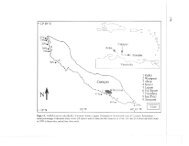
GLENWOOD LOCALITY<br />
HULLS COUNTY, IOWA<br />
FIGURE 29.—Distribution of lodges in the Glenwood locality. Mills County, Iowa.<br />
m) (Larimer, 1957:289). Pony Creek flows into<br />
Keg Creek on the Missouri floodplain. The Keg<br />
Creek watershed is more substantial, draining a<br />
190-square-mile (492-km^) area of Mills County<br />
with a floodplain averaging six-tenths of a mile<br />
(966 m) (Larimer, 1957:289). The well-developed<br />
terraces of Keg Creek appear to offer a more<br />
desirable location for lodges, but the majority of<br />
lodge sites are concentrated adjacent to Pony<br />
Creek. Lodges are also reported at the mouths of<br />
small east-west hollows, exiting directly onto the<br />
floodplain of the Missouri (Anderson, 1961:54;<br />
Proudfit, 1881b:273).<br />
The Glenwood locality therefore conforms to<br />
the "small space" requirements of the locality as<br />
defined by Willey and Phillips, and is substantially<br />
more limited in area than the distribution<br />
of Central <strong>Plains</strong> sites in Iowa postulated by<br />
Keyes (1951). Keyes estimated that Central<br />
<strong>Plains</strong> materials extended 100 miles (161 km)<br />
along the western border of Iowa, from the Missouri<br />
state line north to mid-Monona County.<br />
"Apparently a walk of thirty minutes, or less,<br />
from any one of these houses would have brought<br />
an occupant to a full view of the six-mile-wide<br />
flood plain of the Missouri River" (Keyes,<br />
1951:340).<br />
Keyes' predicted distribution of lodges has not<br />
been demonstrated, however. The lack of supporting<br />
evidence for an extensive distribution of<br />
localities on the Iowa side of the Missouri River<br />
is perplexing when compared to the distribution<br />
demonstrated by Paul Cooper's 1938 fieldwork<br />
(1939:151) in eastern Nebraska:<br />
The cultural traits manifested by the villages in this region<br />
north of Omaha are very similar to those of sites farther to<br />
the south, and are unquestionably referable also to the<br />
Nebraska Culture. This manifestation is thus demonstrated<br />
as having a wide distribution in eastern Nebraska, extending<br />
along the entire eastern border of the state and for an<br />
uncertain distance to the west.<br />
Keyes' estimated extent of Nebraska sites in Iowa<br />
was based on surface collections from several<br />
counties along the bluffs. As intensive surveys are<br />
conducted north of Mills County, it is possible<br />
that additional Nebraska phase lodges will be<br />
located. The potential for finding another locality<br />
on the Iowa side comparable to Glenwood, how-