Plains Indian Studies - Smithsonian Institution Libraries
Plains Indian Studies - Smithsonian Institution Libraries
Plains Indian Studies - Smithsonian Institution Libraries

You also want an ePaper? Increase the reach of your titles
YUMPU automatically turns print PDFs into web optimized ePapers that Google loves.
176 SMITHSONIAN CONTRIBUTIONS TO ANTHROPOLOGY<br />
the requirements of particular construction projects)<br />
have produced data sets that vary both in<br />
quantity and quality. The shift of focus from<br />
tradition to locality-specific studies emphasizing<br />
the cultural and ecological setting obviates, to<br />
some extent, many of the problems involved in<br />
the broader synthetic approaches.<br />
A second important advantage of establishing<br />
the locality as the primary unit of analysis lies in<br />
the researcher's detailed familiarity with previous<br />
work conducted in a given area, which expedites<br />
the process of reassessing and refining earlier<br />
research. Virtually every locality of the Central<br />
<strong>Plains</strong> has a long history of excavations and excavators,<br />
and uncritical acceptance of early work<br />
can provide misleading results. For example, in<br />
the 1930s, Ellison Orr identified some of the<br />
lodges in the Glenwood locality as circular rather<br />
than square in outline. Since all of the lodges<br />
visited by the early explorers in the Missouri<br />
valley were circular in form, the presence of circular<br />
lodges in Glenwood, in addition to the<br />
traditional square form, would provide strong<br />
support for a lengthy sequence of occupation. In<br />
discussing the archeological evidence for changes<br />
in lodge form, Wedel (1934:174) observed:<br />
In the Pawnee area of Nebraska, archaeological research has<br />
shown that this form [circular lodges] characterizes protohistoric<br />
and historic sites. Rectangular lodge remains have<br />
not been found to date in any but prehistoric villages. That<br />
the two types are fundamentally related there seems to be<br />
very little doubt .... Occasionally, as at Sweetwater in the<br />
South Loup drainage, the two are found together, suggesting<br />
a gradual transition from the earlier rectangular to the later<br />
historic circular type.<br />
The circular lodges reported by Orr in Glenwood<br />
were noted by Ives (1955:2) and Anderson<br />
(1961:18) and were included as part of the inventory<br />
of Nebraska phase lodges in an early draft of<br />
Blakeslee and Caldwell's (1979) publication. An<br />
analysis of unpublished correspondence (Hotopp,<br />
1978a: 104-110, 1978b: 123-128) demonstrated<br />
that the reported circular lodge form at Glenwood<br />
was due to excavation errors by Orr rather than<br />
to a valid type for the locality. Once an erroneous<br />
interpretation becomes part of the literature,<br />
however, its uncritical acceptance perpetuates<br />
problems in future analysis. Correcting and refining<br />
can best be conducted by researchers who are<br />
intimately familiar with the history of previous<br />
work in a locality.<br />
Finally, focusing on small scale locality-specific<br />
problems promotes a better understanding of cultural<br />
processes and intralocality variability. As<br />
studies of locality-specific questions are completed,<br />
the results can be translated into hypotheses<br />
to be tested in other localities. This type<br />
of study requires a substantial commitment of<br />
time and resources by investigators. Ideally, the<br />
results of working from the particular to the<br />
general will result in a deeper understanding of<br />
the ecological and cultural adaptations of this<br />
prehistoric culture.<br />
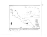
The Glenwood Locality<br />
As defined by Anderson (1961:4), the Glenwood<br />
locality extends approximately 4 miles (6.4<br />
km) into the loess bluffs and about 9 miles (14.5<br />
km) along the Missouri River in Mills County,<br />
Iowa. Mills County is bounded on the west by<br />
the Missouri River, where the floodplain is currently<br />
about 4 miles (6.4 km) wide on the Iowa<br />
side. The floodplain terminates in a series of<br />
abruptly rising loess bluffs that are extensively<br />
dissected by erosion. In his description of the<br />
geology of Mills and Fremont counties, Udden<br />
(1902:167-168) noted the distinctive character of<br />
the bluffs contiguous with the Missouri River<br />
floodplain:<br />
The average thickness of the loess is estimated at about sixty<br />
feet [18 m], but in the bluffs of the Missouri River and for<br />
two miles east [3.2 km], it frequently attains a thickness of a<br />
hundred feet [30 m] and is occasionally 150 feet [45.7 km].<br />
This marked thickening causes an ill defined ridge along the<br />
west border of the uplands in some places but it has been so<br />
greatly affected by erosion that it now exists merely as a<br />
skeleton of divides among labyrinths of gullies and ravines.<br />
The majority of earth lodges in the Glenwood<br />
locality are situated along two southwesterly flowing<br />
drainages and their tributaries (Figure 29).<br />
The westernmost watershed is Pony Creek, which<br />
drains a 15.9-square-mile (41-km^) area with an<br />
average floodplain of approximately 200 feet (61