- Page 3:
DOE/ID-10997 Revision 4 Idaho Natio
- Page 7 and 8: CONTENTS ABSTRACT .................
- Page 9 and 10: Appendix J—INL Cultural Resource
- Page 11 and 12: ACRONYMS, ABBREVIATIONS, AND SYMBOL
- Page 13 and 14: Co. company COM communication CP-1
- Page 15 and 16: FFA/CO FONSI FPR FRAN FS&R Federal
- Page 17 and 18: kV L LAK LAN LCCDA LCRE LDRD LESAT
- Page 19 and 20: NuPac Nuclear Pacific (manufacture
- Page 21 and 22: SM Stationary Medium Power reactor
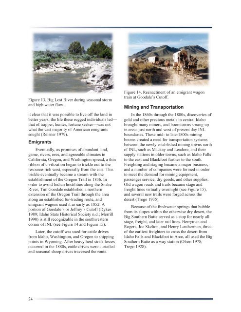
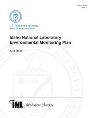
- Page 23 and 24: W west WAG waste area group WCF Was
- Page 25 and 26: GLOSSARY The terms defined in this
- Page 27 and 28: compliance. Adherence to specific p
- Page 29 and 30: historic context. An organizing str
- Page 31 and 32: multi-component. A descriptive term
- Page 33 and 34: econnaissance survey. A field surve
- Page 35 and 36: Idaho National Laboratory Cultural
- Page 37 and 38: elevant federal regulations, DOE-ID
- Page 39 and 40: programs nationwide. As such, all I
- Page 41: organization, agency, museum, or ot
- Page 44 and 45: Figure 3. Regional setting of Idaho
- Page 46 and 47: extruded from low-shield volcanoes,
- Page 48 and 49: The relatively permanent water sour
- Page 50 and 51: Gradually, as a result of this pale
- Page 52 and 53: fauna, including now-extinct forms
- Page 54 and 55: Figure 11. Elko corner-notched dart
- Page 56 and 57: The absence of a restrictive sociop
- Page 60 and 61: In the 1890s another way station or
- Page 62 and 63: History: 1942 to Present In 1942, t
- Page 64 and 65: south of MTR at ATRC. At the time o
- Page 66 and 67: The Loss of Fluid Test (LOFT) progr
- Page 68 and 69: Figure 24. Aerial view of MFC. Othe
- Page 70 and 71: Responsibility for Resource Managem
- Page 72 and 73: and sacred American Indian sites sc
- Page 74 and 75: to the broad patterns of our histor
- Page 76 and 77: available information of value. The
- Page 78 and 79: times, including during an annual m
- Page 80 and 81: INL CRM Office staff have also deve
- Page 82 and 83: Figure 27. National Historic Preser
- Page 84 and 85: encountered during any activity. Ac
- Page 86 and 87: 2. No Adverse Effect. Cultural reso
- Page 88 and 89: egular commentary on INL CRM Office
- Page 90 and 91: Bonnichsen, B. and R. M. Breckenrid
- Page 92 and 93: Executive Order 13287, 2003, “Pre
- Page 94 and 95: Kurten, B. and E. Anderson, 1972,
- Page 96 and 97: Pierce, K. L. and W. E. Scott, 1982
- Page 98 and 99: Stacy, S., 2005a, Historic American
- Page 101: Appendix A Legal Basis for Cultural
- Page 104 and 105: “Federal Records Act of 1950,”
- Page 106 and 107: * “National Environmental Policy
- Page 108 and 109:
“Preserve America,” 2003 (EO 13
- Page 110 and 111:
DEPARTMENT OF ENERGY DIRECTIVES Cul
- Page 112 and 113:
Figure 28. INL Environmental Policy
- Page 114 and 115:
Figure 30. Bechtel BWXT Environment
- Page 116 and 117:
*LWP-8000, “Environmental Instruc
- Page 119 and 120:
Appendix B American Indian Interest
- Page 121 and 122:
3. Consultation. DOE and the Tribes
- Page 123:
Between the Shoshone-Bannock Tribes
- Page 127 and 128:
BACKGROUND U.S. DEPARTMENT OF ENERG
- Page 129 and 130:
III. THE DEPARTMENT WILL ESTABLISH
- Page 131:
Attachment 2 Agreement-in-Principle
- Page 135 and 136:
101
- Page 137 and 138:
103
- Page 139 and 140:
105
- Page 141 and 142:
107
- Page 143 and 144:
109
- Page 145 and 146:
111
- Page 147 and 148:
113
- Page 149 and 150:
Attachment 3 Communications Protoco
- Page 151 and 152:
Communications Protocol August 10,
- Page 153 and 154:
undertaking. The intent of this not
- Page 155 and 156:
D. Revision of Procedures These pro
- Page 157 and 158:
Attachment 4 Memorandum of Agreemen
- Page 159 and 160:
125
- Page 161 and 162:
127
- Page 163 and 164:
Appendix C Standards and Procedures
- Page 165 and 166:
Appendix C Standards and Procedures
- Page 167 and 168:
As the INL Cultural Resource Manage
- Page 169 and 170:
inclusion in the INL cultural resou
- Page 171 and 172:
SHPO, and other involved parties. I
- Page 173 and 174:
esource base and enhance long-term
- Page 175 and 176:
of any given test excavation will d
- Page 177 and 178:
discussed under test excavations. A
- Page 179 and 180:
e eligible to the National Register
- Page 181 and 182:
Idaho National Laboratory Cultural
- Page 183 and 184:
Figure 33. INL CRM Office permit ap
- Page 185 and 186:
Figure 35. Intermountain Antiquitie
- Page 187 and 188:
Figure 35. (continued.) 153
- Page 189 and 190:
Figure 35. (continued.) 155
- Page 191 and 192:
Figure 35. (continued.) 157
- Page 193 and 194:
Appendix D Strategies and Procedure
- Page 195 and 196:
Appendix D Strategies and Procedure
- Page 197 and 198:
uildings have been demolished (e.g.
- Page 199 and 200:
POLICIES AND PROCEDURES FOR MANAGIN
- Page 201 and 202:
In addition to internal procedures,
- Page 203 and 204:
Council consultation, additional ti
- Page 205 and 206:
Determination of eligibility 35-mm
- Page 207 and 208:
Appendix E Research Designs 173
- Page 209 and 210:
Appendix E Research Designs INTRODU
- Page 211 and 212:
Therefore, the addressable research
- Page 213 and 214:
INL Research Design Each of the pro
- Page 215 and 216:
within the last 600 to 1000 years i
- Page 217 and 218:
originate and where most processing
- Page 219 and 220:
Site taxonomy is based on the amoun
- Page 221 and 222:
of the limited number of sites exca
- Page 223 and 224:
Research Topic: Historic Indian Occ
- Page 225 and 226:
However, artifacts that often have
- Page 227 and 228:
Research Question—Does the dramat
- Page 229 and 230:
stages of stone tool manufacture ar
- Page 231 and 232:
Appendix F Historic Contexts 197
- Page 233 and 234:
Appendix F Historic Contexts INTROD
- Page 235 and 236:
The Pocatello Naval Ordnance Plant.
- Page 237 and 238:
constructed) a rocket ordnance test
- Page 239 and 240:
In the Residential Area, the civili
- Page 241 and 242:
occurrence of such episodes, how to
- Page 243 and 244:
1952. These structures were — and
- Page 245 and 246:
scarce resource. Only uranium could
- Page 247 and 248:
highway could observe the steam and
- Page 249 and 250:
approved in 1962. To the dismay of
- Page 251 and 252:
supplied the NRTS as well. Argonne-
- Page 253 and 254:
after further testing. When a speci
- Page 255 and 256:
months or years of radiation exposu
- Page 257 and 258:
The MTR auxiliary buildings were or
- Page 259 and 260:
The MTR played a role in most of th
- Page 261 and 262:
Because the reactor would operate a
- Page 263 and 264:
working area, the Advanced Test Rea
- Page 265 and 266:
partners in the safe operation and
- Page 267 and 268:
DD&D of the OMRE. The facility then
- Page 269 and 270:
and Drydock Company would develop t
- Page 271 and 272:
Initially, the Navy sent about thre
- Page 273 and 274:
The Army, therefore, set out to exp
- Page 275 and 276:
gas-driven turbo-generator. It reac
- Page 277 and 278:
$6-7 million; for diesel, $350,000.
- Page 279 and 280:
The ANP support facilities were con
- Page 281 and 282:
Related to the SNAP program, the AE
- Page 283 and 284:
The SPERT experiments took place at
- Page 285 and 286:
vessel and control rod drive could
- Page 287 and 288:
The PBF reactor achieved its first
- Page 289 and 290:
Sub-Theme: Commercial Reactor Safet
- Page 291 and 292:
uranium was not a hazard, but the I
- Page 293 and 294:
North of the Waste Treatment Comple
- Page 295 and 296:
pneumatic transport techniques. Phi
- Page 297 and 298:
enriched fuels, aluminum-clad fuels
- Page 299 and 300:
uildings, and craft shops. Then the
- Page 301 and 302:
of building the reactor. Although t
- Page 303 and 304:
DOE is actively seeking new custome
- Page 305 and 306:
The three prototypes are presently
- Page 307 and 308:
ICPP complex. Changes in waste mana
- Page 309 and 310:
came to a halt, unfinished and sudd
- Page 311 and 312:
As the Cold War escalated, the numb
- Page 313 and 314:
e 3 × 10 11 curies, with an estima
- Page 315 and 316:
also became concerned about Rocky F
- Page 317 and 318:
Some of the cleanup involved moving
- Page 319 and 320:
cleanup, and remediation of nuclear
- Page 321 and 322:
Appendix G Programmatic Agreement 2
- Page 323 and 324:
289
- Page 325 and 326:
291
- Page 327 and 328:
293
- Page 329 and 330:
Appendix H Inventory of Known INL A
- Page 331 and 332:
Appendix H Inventory of Known INL A
- Page 333 and 334:
Table 5. (continued). INL Prehistor
- Page 335 and 336:
Table 5. (continued). INL Prehistor
- Page 337 and 338:
Table 5. (continued). INL Prehistor
- Page 339 and 340:
Table 5. (continued). INL Prehistor
- Page 341 and 342:
Table 5. (continued). INL Prehistor
- Page 343 and 344:
Table 5. (continued). INL Prehistor
- Page 345 and 346:
Table 5. (continued). INL Prehistor
- Page 347 and 348:
Table 5. (continued). INL Prehistor
- Page 349 and 350:
Table 5. (continued). INL Prehistor
- Page 351 and 352:
Table 5. (continued). INL Prehistor
- Page 353 and 354:
Table 5. (continued). INL Prehistor
- Page 355 and 356:
Table 5. (continued). INL Prehistor
- Page 357 and 358:
Table 5. (continued). INL Prehistor
- Page 359 and 360:
Table 5. (continued). INL Prehistor
- Page 361 and 362:
Table 5. (continued). INL Prehistor
- Page 363 and 364:
Table 5. (continued). INL Prehistor
- Page 365 and 366:
Table 6. INL prehistoric isolated f
- Page 367 and 368:
Table 6. (continued). INL Prehistor
- Page 369 and 370:
Table 6. (continued). INL Prehistor
- Page 371 and 372:
Table 6. (continued). INL Prehistor
- Page 373 and 374:
Table 6. (continued). INL Prehistor
- Page 375 and 376:
Table 6. (continued). INL Prehistor
- Page 377 and 378:
Table 6. (continued). INL Prehistor
- Page 379 and 380:
Table 6. (continued). INL Prehistor
- Page 381 and 382:
Table 6. (continued). INL Prehistor
- Page 383 and 384:
Table 6. (continued). INL Prehistor
- Page 385 and 386:
Table 6. (continued). INL Prehistor
- Page 387 and 388:
Table 6. (continued). INL Prehistor
- Page 389 and 390:
Table 6. (continued). INL Prehistor
- Page 391 and 392:
Table 6. (continued). INL Prehistor
- Page 393 and 394:
Table 6. (continued). INL Prehistor
- Page 395 and 396:
Table 6. (continued). INL Prehistor
- Page 397 and 398:
Table 6. (continued). INL Prehistor
- Page 399 and 400:
Table 7. INL historic and multi-com
- Page 401 and 402:
Table 7. (continued). INL Historic
- Page 403 and 404:
Table 7. (continued). INL Historic
- Page 405 and 406:
Table 7. (continued). INL Historic
- Page 407 and 408:
Appendix I INL Architectural Proper
- Page 409 and 410:
Appendix I INL Architectural Proper
- Page 411 and 412:
Table 8. Surveyed INL properties. B
- Page 413 and 414:
Table 8. (continued). Building or S
- Page 415 and 416:
Table 8. (continued). Building or S
- Page 417 and 418:
Table 8. (continued). Building or S
- Page 419 and 420:
Table 8. (continued). Building or S
- Page 421 and 422:
Table 8. (continued). Building or S
- Page 423 and 424:
Table 8. (continued). Building or S
- Page 425 and 426:
Table 8. (continued). Building or S
- Page 427 and 428:
Table 8. (continued). Building or S
- Page 429 and 430:
Table 8. (continued). Building or S
- Page 431 and 432:
Table 8. (continued). Building or S
- Page 433 and 434:
Table 8. (continued). Building or S
- Page 435 and 436:
Table 8. (continued). Building or S
- Page 437 and 438:
Table 8. (continued). Building or S
- Page 439 and 440:
Table 8. (continued). Building or S
- Page 441 and 442:
Appendix J INL Cultural Resource Pr
- Page 443 and 444:
Appendix J INL Cultural Resource Pr
- Page 445 and 446:
Table 9. (continued). INL Cultural
- Page 447 and 448:
Table 9. (continued). Project Numbe
- Page 449 and 450:
Table 9. (continued). Project Numbe
- Page 451 and 452:
Table 9. (continued). Project Numbe
- Page 453 and 454:
Table 9. (continued). Project Numbe
- Page 455 and 456:
Table 9. (continued). INL Cultural
- Page 457 and 458:
Table 9. (continued). Project Numbe
- Page 459 and 460:
Table 9. (continued). INL Cultural
- Page 461 and 462:
Table 9. (continued). Project Numbe
- Page 463 and 464:
Table 9. (continued). Project Numbe
- Page 465 and 466:
Table 9. (continued). INL Cultural
- Page 467 and 468:
Table 9. (continued). Project Numbe
- Page 469 and 470:
Table 10. (continued). INL CRM Offi
- Page 471 and 472:
Table 10. (continued). INL CRM Offi
- Page 473 and 474:
Table 11. INL Cultural Resource Man
- Page 475 and 476:
Table 11. (continued). Project Numb
- Page 477 and 478:
Table 11. (continued). Project Numb
- Page 479 and 480:
Table 11. (continued). Project Numb
- Page 481 and 482:
Table 11. (continued). Project Numb
- Page 483 and 484:
Table 11. (continued). Project Numb
- Page 485 and 486:
Table 11. (continued). Project Numb
- Page 487 and 488:
Appendix K Goals and Tasks 453
- Page 489 and 490:
Appendix K Goals and Tasks INTRODUC
- Page 491 and 492:
Task 2. Maintain memberships in pro
- Page 493 and 494:
Appendix L Idaho National Laborator
- Page 495 and 496:
Appendix L Idaho National Laborator
- Page 497:
Figure 38. Example of INL Cultural