- Page 1 and 2:
EXECUTIVE SUMMARY Intelligent Trans
- Page 3 and 4:
INTELLIGENT TRANSPORTATION SYSTEMS
- Page 5 and 6:
INTELLIGENT TRANSPORTATION SYSTEMS
- Page 7 and 8:
INTELLIGENT TRANSPORTATION SYSTEMS
- Page 9 and 10:
INTELLIGENT TRANSPORTATION SYSTEMS
- Page 11 and 12:
INTELLIGENT TRANSPORTATION SYSTEMS
- Page 13 and 14:
INTELLIGENT TRANSPORTATION SYSTEMS
- Page 15 and 16:
Intelligent Transportation Systems
- Page 17 and 18:
6 ITS SOLUTIONS TOOLBOX............
- Page 19 and 20:
LIST OF ACRONYMS AASHTO ASTM ATIS A
- Page 21 and 22:
LIST OF WEB RESOURCES This ITS Stra
- Page 23 and 24:
SACOG ITS Strategic Deployment Plan
- Page 25 and 26:
Land use planning, transportation p
- Page 27 and 28:
1.6 USDOT Regional ITS Architecture
- Page 29 and 30:
2 VISION STATEMENT 2.1 Original Sac
- Page 31 and 32:
ITS is the technology that business
- Page 33 and 34:
3 GAP ASSESSMENT Up to this point,
- Page 35 and 36:
Table 3.1: Background Documents for
- Page 37 and 38:
3.3 Gap Assessment Gap Assessment P
- Page 39 and 40:
• Improve mobility and reliabilit
- Page 41 and 42:
4 SACRAMENTO REGIONAL ITS ARCHITECT
- Page 43 and 44:
esponds/dispatches emergency vehicl
- Page 45 and 46:
Table 4.1: Stakeholders Stakeholder
- Page 47 and 48:
Table 4.2 identifies the roles and
- Page 49 and 50:
Table 4.2: Roles and Responsibiliti
- Page 51 and 52:
Table 4.2: Roles and Responsibiliti
- Page 53 and 54:
Table 4.3: Inventory by Stakeholder
- Page 55 and 56:
Table 4.3: Inventory by Stakeholder
- Page 57 and 58:
Table 4.3: Inventory by Stakeholder
- Page 59 and 60:
Table 4.3: Inventory by Stakeholder
- Page 61 and 62:
Table 4.3: Inventory by Stakeholder
- Page 63 and 64:
Table 4.4: Inventory Sorted by Enti
- Page 65 and 66:
Table 4.4: Inventory Sorted by Enti
- Page 67 and 68:
Table 4.4: Inventory Sorted by Enti
- Page 69 and 70:
4.5 Market Packages and Performance
- Page 71 and 72:
Market Package Table 4.5: Market Pa
- Page 73 and 74:
Demand Model (SACMET) to simulate I
- Page 75 and 76:
Market Package ATIS02 Market Packag
- Page 77 and 78:
Market Package MC01 MC02 MC03 MC04
- Page 79 and 80:
Figure 4.2: Sacramento Regional ITS
- Page 81 and 82:
The market packages that were custo
- Page 83 and 84:
4.7 Functional Requirements Functio
- Page 85 and 86:
database (which identifies standard
- Page 87 and 88:
The previous tables provide general
- Page 89 and 90:
Table 4.8: Individual Standards wit
- Page 91 and 92:
5.2 Methodology and Analysis The fo
- Page 93 and 94:
At a minimum, the Change Form requi
- Page 95 and 96:
These responsibilities may be assig
- Page 97 and 98:
stakeholders may necessitate updati
- Page 99 and 100:
including keeping a baseline Archit
- Page 101 and 102:
6 ITS SOLUTIONS TOOLBOX The previou
- Page 103 and 104:
Example #2 -Install CCTV Camera Des
- Page 105 and 106:
SACOG ITS SOLUTIONS TOOLBOX FOR MAI
- Page 107 and 108:
SACOG ITS SOLUTIONS TOOLBOX FOR MAI
- Page 109 and 110:
SACOG ITS SOLUTIONS TOOLBOX FOR MAI
- Page 111 and 112:
Sacramento Area Council of Governme
- Page 113 and 114:
ITS Solutions Pedestrian Improvemen
- Page 115 and 116:
Sacramento Area Council of Governme
- Page 117 and 118:
Sacramento Area Council of Governme
- Page 119 and 120:
Sacramento Area Council of Governme
- Page 121 and 122:
Sacramento Area Council of Governme
- Page 123 and 124:
Sacramento Area Council of Governme
- Page 125 and 126:
Sacramento Area Council of Governme
- Page 127 and 128:
Sacramento Area Council of Governme
- Page 129 and 130:
Sacramento Area Council of Governme
- Page 131 and 132:
Sacramento Area Council of Governme
- Page 133 and 134:
Priority Level Table 7.1: Project S
- Page 135 and 136:
Priority Level M H H M H H H M M Ta
- Page 137 and 138:
Priority Level Table 7.2: Project S
- Page 139 and 140:
Table 7.3: Project Sequencing Lo
- Page 141 and 142:
Project #2 -Sacramento 511 Traveler
- Page 143 and 144:
Project #7 -Arden Way ITS Descripti
- Page 145 and 146:
7.3 Gap Resolution In Section 3.3 t
- Page 147 and 148:
Table 7.5: Projects for Regional Ar
- Page 149 and 150:
Table 7.6: Projects for ITS Vision
- Page 151 and 152:
Table 7.7: Potential Agreements for
- Page 153 and 154:
7.5 Mainstreaming “Mainstreaming
- Page 155 and 156:
a. When planning projects, use ITS
- Page 157 and 158:
Appendix A
- Page 159 and 160:
TABLE OF CONTENTS COMMUNITY OUTREAC
- Page 161 and 162:
2. OUTREACH PROGRAM OBJECTIVES The
- Page 163 and 164:
4. MEETINGS AND WORKSHOPS The SACOG
- Page 165 and 166:
All comments received at the first
- Page 167 and 168:
6. FACILITATE TECHNICAL REVIEW AND
- Page 169 and 170:
Appendix B
- Page 171 and 172:
to integrate various transit servic
- Page 173 and 174:
subsequent transportation bills) in
- Page 176 and 177:
TABLE OF CONTENTS ITS EXISTING COND
- Page 178 and 179:
SACOG ITS Strategic Deployment Plan
- Page 180 and 181:
List of Background Documents for th
- Page 182 and 183:
APPENDIX A - EXISTING CONDITIONS SU
- Page 184 and 185:
STUDY SACOG Blueprint Transportatio
- Page 186 and 187:
STUDY SACOG Metropolitan Transporta
- Page 188 and 189:
STUDY AGENCY DATE PURPOSE City of C
- Page 190 and 191:
STUDY AGENCY City of Davis General
- Page 192 and 193:
STUDY AGENCY City of Elk Grove Gene
- Page 194 and 195:
STUDY City of Isleton Comprehensive
- Page 196 and 197:
City of Lincoln General Plan - Goal
- Page 198 and 199:
STUDY AGENCY City of Placerville Ge
- Page 200 and 201:
STUDY AGENCY City of Rocklin Genera
- Page 202 and 203:
STUDY City of Roseville General Pla
- Page 204 and 205:
STUDY City of Sacramento General Pl
- Page 206 and 207:
STUDY AGENCY City of West Sacrament
- Page 208 and 209:
STUDY AGENCY City of Woodland Gener
- Page 210 and 211:
STUDY AGENCY Yuba City General Plan
- Page 212 and 213:
STUDY AGENCY El Dorado County Gener
- Page 214 and 215:
STUDY AGENCY Placer County General
- Page 216 and 217:
STUDY AGENCY County of Sacramento G
- Page 218 and 219:
STUDY AGENCY Sutter County General
- Page 220 and 221:
STUDY AGENCY Yolo County http://www
- Page 222 and 223:
STUDY AGENCY Yuba County General Pl
- Page 224 and 225:
STUDY AGENCY Sacramento Transportat
- Page 226 and 227:
STUDY AGENCY City of Elk Grove Inte
- Page 228 and 229:
STUDY AGENCY Sacramento Regional IT
- Page 230 and 231:
STUDY Placer Parkway Interconnect P
- Page 232 and 233: Elk Grove-Rancho Cordova-El Dorado
- Page 234 and 235: STUDY San Joaquin Valley ITS Strate
- Page 236 and 237: STUDY AGENCY Tahoe Gateway ITS Stra
- Page 238 and 239: STUDY Tahoe Basin ITS Strategic Dep
- Page 240 and 241: STUDY AGENCY Bay Area Regional ITS
- Page 242 and 243: STUDY AGENCY Regional Street Networ
- Page 244 and 245: STUDY AGENCY Multi-Corridor Study S
- Page 246 and 247: STUDY California Statewide ITS Arch
- Page 248 and 249: Appendix D
- Page 250 and 251: SACOG ITS System Deployment Plan Ta
- Page 252 and 253: SACOG ITS System Deployment Plan Ta
- Page 254 and 255: Appendix E
- Page 256 and 257: 1. INTRODUCTION This report is the
- Page 258 and 259: 2. METHODOLOGY AND ANALYSIS To full
- Page 260 and 261: o When optimizing signal operations
- Page 262 and 263: operators, travelers, and other ITS
- Page 264 and 265: Commercial Vehicle Operations Emerg
- Page 266 and 267: • ATMS14 -Advanced Railroad Grade
- Page 269 and 270: Summary of Prioritized Market Packa
- Page 271 and 272: High Priority Market Packages for t
- Page 273 and 274: • Improve transit level of servic
- Page 275 and 276: Transit Security (APTS05) High Prio
- Page 277 and 278: • Integrate Sacramento region ini
- Page 279 and 280: Network Surveillance (ATMS01) High
- Page 281: Surface Street Control (ATMS03) Hig
- Page 285 and 286: Traffic Information Dissemination (
- Page 287 and 288: Regional Traffic Control (ATMS07) H
- Page 289 and 290: Traffic Incident Management System
- Page 291 and 292: Disaster Response and Recovery (EM0
- Page 293 and 294: Work Zone Management (MC08) High Pr
- Page 295 and 296: Medium Priority Market Packages for
- Page 297 and 298: ITS Virtual Data Warehouse (AD03) M
- Page 299 and 300: Transit Maintenance (APTS06) Medium
- Page 301 and 302: varying media (i.e., web, TV, inv
- Page 303 and 304: Integrated Transportation Managemen
- Page 305 and 306: HOV Lane Management (ATMS05) Medium
- Page 307 and 308: Traffic Forecast and Demand Managem
- Page 309 and 310: Standard Railroad Grade Crossing (A
- Page 311 and 312: Speed Monitoring (ATMS19) Medium Pr
- Page 313 and 314: Emergency Routing (EM02) Medium Pri
- Page 315 and 316: Transportation Infrastructure Prote
- Page 317 and 318: Early Warning System (EM07) Medium
- Page 319 and 320: Road Weather Data Collection (MC03)
- Page 321 and 322: Roadway Maintenance and Constructio
- Page 323 and 324: Appendix G
- Page 325 and 326: Market Market Package Name Element
- Page 327 and 328: Market Market Package Name Element
- Page 329 and 330: Market Market Package Name Element
- Page 331 and 332: Market Market Package Name Element
- Page 333 and 334:
Market Market Package Name Element
- Page 335 and 336:
Market Market Package Name Element
- Page 337 and 338:
Market Market Package Name Element
- Page 339 and 340:
Market Package ATMS08 ATMS08 ATMS08
- Page 341 and 342:
Market Package ATMS14 ATMS14 ATMS14
- Page 343 and 344:
Market Package EM01 EM01 Market Pac
- Page 345 and 346:
Market Market Package Name Element
- Page 347 and 348:
Market Package EM08 EM08 EM08 Marke
- Page 349 and 350:
Market Package EM09 EM09 EM09 EM09
- Page 351 and 352:
Market Package MC01 Market Package
- Page 353 and 354:
Market Package MC04 MC04 MC04 Marke
- Page 355 and 356:
Market Market Package Name Element
- Page 357 and 358:
Market Package MC10 MC10 MC10 MC10
- Page 359 and 360:
Appendix H
- Page 363 and 364:
ATMS01 - Network Surveillance Caltr
- Page 365 and 366:
ATMS01 - Network Surveillance City
- Page 367 and 368:
ATMS01 - Network Surveillance Rosev
- Page 369 and 370:
ATMS01 - Network Surveillance Sacra
- Page 371 and 372:
ATMS01 - Network Surveillance City
- Page 373 and 374:
ATMS01 - Network Surveillance City
- Page 375 and 376:
ATMS01 - Network Surveillance City
- Page 377 and 378:
ATMS02 - Probe Surveillance Sacrame
- Page 379 and 380:
ATMS03 - Surface Street Control Sac
- Page 381 and 382:
ATMS03 - Surface Street Control Cit
- Page 383 and 384:
ATMS03 - Surface Street Control Ros
- Page 385 and 386:
ATMS03 - Surface Street Control Cit
- Page 387 and 388:
ATMS03 - Surface Street Control Cit
- Page 389 and 390:
ATMS03 - Surface Street Control Cit
- Page 391 and 392:
ATMS03 - Surface Street Control Yub
- Page 393 and 394:
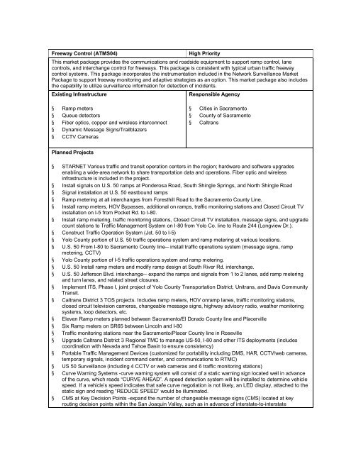
ATMS04 - Freeway Control Caltrans D
- Page 395 and 396:
ATMS06 - Traffic Information Dissem
- Page 397 and 398:
ATMS06 - Traffic Information Dissem
- Page 399 and 400:
ATMS06 - Traffic Information Dissem
- Page 401 and 402:
ATMS06 - Traffic Information Dissem
- Page 403 and 404:
ATMS06 - Traffic Information Dissem
- Page 405 and 406:
ATMS06 - Traffic Information Dissem
- Page 407 and 408:
ATMS07 - Regional Traffic Control S
- Page 409 and 410:
ATMS07 - Regional Traffic Control C
- Page 411 and 412:
Incident Management Overview ATMS08
- Page 413 and 414:
ATMS08 - Incident Management Caltra
- Page 415 and 416:
ATMS08 - Incident Management City o
- Page 417 and 418:
ATMS08 - Incident Management Munici
- Page 419 and 420:
ATMS08 - Incident Management Caltra
- Page 421 and 422:
ATMS08 - Incident Management City o
- Page 423 and 424:
ATMS08 - Incident Management City o
- Page 425 and 426:
ATMS08 - Incident Management City o
- Page 427 and 428:
ATMS08 - Incident Management City o
- Page 429 and 430:
ATMS08 - Incident Management City o
- Page 431 and 432:
ATMS08 - Incident Management Munici
- Page 433 and 434:
ATMS08 - Incident Management Sacram
- Page 435 and 436:
ATMS08 - Incident Management City o
- Page 437 and 438:
ATMS08 - Incident Management Sacram
- Page 439 and 440:
ATMS08 - Incident Management MCM to
- Page 441 and 442:
ATMS08 - Incident Management MCM to
- Page 443 and 444:
ATMS08 - Incident Management (EM to
- Page 445 and 446:
ATMS08 - Incident Management (EM to
- Page 447 and 448:
ATMS08 - Incident Management Flood
- Page 449 and 450:
ATMS08 - Incident Management Caltan
- Page 451 and 452:
ATMS11 - Emissions Monitoring and M
- Page 453 and 454:
ATMS13 - Standard Railroad Crossing
- Page 455 and 456:
ATMS13 - Standard Railroad Crossing
- Page 457 and 458:
ATMS14 - Advanced Railroad Grade Cr
- Page 459:
ATMS16 - Parking Facility Managemen
- Page 462 and 463:
MC01 - Maintenance and Construction
- Page 464 and 465:
MC02 - Maintenance and Construction
- Page 466 and 467:
MC02 - Maintenance and Construction
- Page 468 and 469:
MC03 - Road Weather Data Collection
- Page 470 and 471:
MC03 - Road Weather Data Collection
- Page 472 and 473:
MC04 - Weather Information Processi
- Page 474 and 475:
MC04 - Weather Information Processi
- Page 476 and 477:
MC06 - Winter Maintenance Caltrans
- Page 478 and 479:
MC07 - Roadway Maintenance and Cons
- Page 480 and 481:
MC07 - Roadway Maintenance and Cons
- Page 482 and 483:
MC07 - Roadway Maintenance and Cons
- Page 484 and 485:
MC07 - Roadway Maintenance and Cons
- Page 486 and 487:
MC07 - Roadway Maintenance and Cons
- Page 488 and 489:
MC07 - Roadway Maintenance and Cons
- Page 490 and 491:
MC07 - Roadway Maintenance and Cons
- Page 492 and 493:
MC08 - Work Zone Management Sacrame
- Page 494 and 495:
MC08 - Work Zone Management Other C
- Page 496 and 497:
MC08 - Work Zone Management City of
- Page 498 and 499:
MC08 - Work Zone Management City of
- Page 500 and 501:
MC08 - Work Zone Management City of
- Page 502 and 503:
MC08 - Work Zone Management City of
- Page 504 and 505:
MC08 - Work Zone Management Municip
- Page 506 and 507:
MC10 - Maintenance and Construction
- Page 508 and 509:
MC10 - Maintenance and Construction
- Page 510 and 511:
MC10 - Maintenance and Construction
- Page 512 and 513:
MC10 - Maintenance and Construction
- Page 514 and 515:
MC10 - Maintenance and Construction
- Page 516 and 517:
MC10 - Maintenance and Construction
- Page 518 and 519:
MC10 - Maintenance and Construction
- Page 520 and 521:
MC10 - Maintenance and Construction
- Page 522 and 523:
MC10 - Maintenance and Construction
- Page 524 and 525:
MC10 - Maintenance and Construction
- Page 526 and 527:
MC10 - Maintenance and Construction
- Page 528 and 529:
MC10 - Maintenance and Construction
- Page 531 and 532:
EM01 - Emergency Call-Taking and Di
- Page 533 and 534:
EM01 - Emergency Call-Taking and Di
- Page 535 and 536:
EM01 - Emergency Call-Taking and Di
- Page 537 and 538:
EM01 - Emergency Call-Taking and Di
- Page 539 and 540:
EM01 - Emergency Call-Taking and Di
- Page 541 and 542:
EM01 - Emergency Call-Taking and Di
- Page 543 and 544:
EM02 - Emergency Routing Sacramento
- Page 545 and 546:
EM02 - Emergency Routing Local Law
- Page 547 and 548:
EM02 - Emergency Routing Local Fire
- Page 549 and 550:
EM02 - Emergency Routing Local Fire
- Page 551 and 552:
EM04 - Roadway Service Patrols Free
- Page 553 and 554:
EM06 - Wide Area Alert Amber Alert
- Page 555 and 556:
EM06 - Wide Area Alert State EOC (2
- Page 557 and 558:
EM06 - Wide Area Alert Municipal EO
- Page 559 and 560:
EM07 - Early Warning System Weather
- Page 561 and 562:
EM08 - Disaster Response and Recove
- Page 563 and 564:
EM08 - Disaster Response and Recove
- Page 565 and 566:
EM09 - Evacuation and Reentry Manag
- Page 567 and 568:
EM09 - Evacuation and Reentry Manag
- Page 569:
EM10 - Disaster Traveler Informatio
- Page 572 and 573:
AD1 - ITS Data Mart Traffic Operati
- Page 574 and 575:
AD1 - ITS Data Mart Statewide Data
- Page 576 and 577:
AD1 - ITS Data Mart RT Transit Mana
- Page 578:
AD3 - ITS Virtual Data Warehouse SA
- Page 581 and 582:
APTS1 - Transit Vehicle Tracking Yo
- Page 583 and 584:
APTS1 - Transit Vehicle Tracking In
- Page 585 and 586:
APTS1 - Transit Vehicle Tracking Lo
- Page 587 and 588:
APTS1 - Transit Vehicle Tracking El
- Page 589 and 590:
APTS1 - Transit Vehicle Tracking Fo
- Page 591 and 592:
APTS1 - Transit Vehicle Tracking Yu
- Page 593 and 594:
APTS2 - Transit Fixed-Route Operati
- Page 595 and 596:
APTS2 - Transit Fixed-Route Operati
- Page 597 and 598:
APTS2 - Transit Fixed-Route Operati
- Page 599 and 600:
APTS2 - Transit Fixed-Route Operati
- Page 601 and 602:
APTS2 - Transit Fixed-Route Operati
- Page 603 and 604:
APTS3 - Demand Response Transit Ope
- Page 605 and 606:
APTS3 - Demand Response Roseville T
- Page 607 and 608:
APTS3 - Demand Response e-tran Tran
- Page 609 and 610:
APTS4 - Transit Passenger and Fare
- Page 611 and 612:
APTS4 - Transit Passenger and Fare
- Page 613 and 614:
APTS5 - Transit Security Light Rail
- Page 615 and 616:
APTS5 - Transit Security El Dorado
- Page 617 and 618:
APTS5 - Transit Security Folsom Sta
- Page 619 and 620:
APTS5 - Transit Security Folsom Sta
- Page 621 and 622:
APTS5 - Transit Security Yuba-Sutte
- Page 623 and 624:
APTS6 - Transit Maintenance County
- Page 625 and 626:
APTS6 - Transit Maintenance El Dora
- Page 627 and 628:
APTS6 - Transit Maintenance Unitran
- Page 629 and 630:
APTS7 - Multi-modal Coordination Re
- Page 631 and 632:
APTS7 - Multi-modal Coordination Li
- Page 633 and 634:
APTS7 - Multi-modal Coordination Yu
- Page 635 and 636:
APTS7 - Multi-modal Coordination e-
- Page 637 and 638:
APTS8 - Transit Traveler Informatio
- Page 639 and 640:
APTS8 - Transit Traveler Informatio
- Page 641 and 642:
APTS8 - Transit Traveler Informatio
- Page 643 and 644:
APTS8 - Transit Traveler Informatio
- Page 646 and 647:
ATIS1 - Broadcast Traveler Informat
- Page 648 and 649:
ATIS1 - Broadcast Traveler Informat
- Page 650 and 651:
ATIS2 - Interactive Traveler Inform
- Page 653:
CVO10 - HAZMAT Management Commercia
- Page 656 and 657:
Element Caltrans Performance Monito
- Page 658 and 659:
Element City of Elk Grove Field Equ
- Page 660 and 661:
Element City of Roseville Police an
- Page 662 and 663:
Element City of West Sacramento Web
- Page 664 and 665:
Element etran Transit Vehicles e
- Page 666 and 667:
Element Municipal Maintenance Vehic
- Page 668 and 669:
Element RT Transit Kiosks RT Transi
- Page 670 and 671:
Element Sacramento County Maintenan
- Page 672 and 673:
Element Equipment Sacramento Intern
- Page 674 and 675:
Element Yolo Bus Dispatch Center Yo
- Page 676 and 677:
Equipment Package Definitions Equip
- Page 678 and 679:
Equipment Package ISP Data Collecti
- Page 680 and 681:
Equipment Package Onboard Fixed R
- Page 682 and 683:
Equipment Package Roadway Incident
- Page 684 and 685:
Equipment Package Transit Center In
- Page 687 and 688:
APPENDIX J: FUNCTIONAL REQUIREMENTS
- Page 689 and 690:
APPENDIX J: FUNCTIONAL REQUIREMENTS
- Page 691 and 692:
APPENDIX J: FUNCTIONAL REQUIREMENTS
- Page 693 and 694:
APPENDIX J: FUNCTIONAL REQUIREMENTS
- Page 695 and 696:
APPENDIX J: FUNCTIONAL REQUIREMENTS
- Page 697 and 698:
APPENDIX J: FUNCTIONAL REQUIREMENTS
- Page 699 and 700:
APPENDIX J: FUNCTIONAL REQUIREMENTS
- Page 701 and 702:
APPENDIX J: FUNCTIONAL REQUIREMENTS
- Page 703 and 704:
APPENDIX J: FUNCTIONAL REQUIREMENTS
- Page 705 and 706:
APPENDIX J: FUNCTIONAL REQUIREMENTS
- Page 707 and 708:
APPENDIX J: FUNCTIONAL REQUIREMENTS
- Page 709 and 710:
APPENDIX J: FUNCTIONAL REQUIREMENTS
- Page 711 and 712:
APPENDIX J: FUNCTIONAL REQUIREMENTS
- Page 713 and 714:
APPENDIX J: FUNCTIONAL REQUIREMENTS
- Page 715 and 716:
APPENDIX J: FUNCTIONAL REQUIREMENTS
- Page 717 and 718:
APPENDIX J: FUNCTIONAL REQUIREMENTS
- Page 719 and 720:
APPENDIX J: FUNCTIONAL REQUIREMENTS
- Page 721 and 722:
APPENDIX J: FUNCTIONAL REQUIREMENTS
- Page 723 and 724:
APPENDIX J: FUNCTIONAL REQUIREMENTS
- Page 725 and 726:
APPENDIX J: FUNCTIONAL REQUIREMENTS
- Page 727 and 728:
APPENDIX J: FUNCTIONAL REQUIREMENTS
- Page 729 and 730:
APPENDIX J: FUNCTIONAL REQUIREMENTS
- Page 731 and 732:
APPENDIX J: FUNCTIONAL REQUIREMENTS
- Page 733 and 734:
APPENDIX J: FUNCTIONAL REQUIREMENTS
- Page 735 and 736:
APPENDIX J: FUNCTIONAL REQUIREMENTS
- Page 737 and 738:
APPENDIX J: FUNCTIONAL REQUIREMENTS
- Page 739 and 740:
APPENDIX J: FUNCTIONAL REQUIREMENTS
- Page 741 and 742:
APPENDIX J: FUNCTIONAL REQUIREMENTS
- Page 743 and 744:
APPENDIX J: FUNCTIONAL REQUIREMENTS
- Page 745 and 746:
APPENDIX J: FUNCTIONAL REQUIREMENTS
- Page 747 and 748:
APPENDIX J: FUNCTIONAL REQUIREMENTS
- Page 749 and 750:
APPENDIX J: FUNCTIONAL REQUIREMENTS
- Page 751 and 752:
APPENDIX J: FUNCTIONAL REQUIREMENTS
- Page 753 and 754:
APPENDIX J: FUNCTIONAL REQUIREMENTS
- Page 755 and 756:
APPENDIX J: FUNCTIONAL REQUIREMENTS
- Page 757 and 758:
APPENDIX J: FUNCTIONAL REQUIREMENTS
- Page 759 and 760:
APPENDIX J: FUNCTIONAL REQUIREMENTS
- Page 761 and 762:
APPENDIX J: FUNCTIONAL REQUIREMENTS
- Page 763 and 764:
APPENDIX J: FUNCTIONAL REQUIREMENTS
- Page 765 and 766:
APPENDIX J: FUNCTIONAL REQUIREMENTS
- Page 767 and 768:
APPENDIX J: FUNCTIONAL REQUIREMENTS
- Page 769 and 770:
APPENDIX J: FUNCTIONAL REQUIREMENTS
- Page 771 and 772:
APPENDIX J: FUNCTIONAL REQUIREMENTS
- Page 773 and 774:
APPENDIX J: FUNCTIONAL REQUIREMENTS
- Page 775 and 776:
APPENDIX J: FUNCTIONAL REQUIREMENTS
- Page 777 and 778:
APPENDIX J: FUNCTIONAL REQUIREMENTS
- Page 779 and 780:
APPENDIX J: FUNCTIONAL REQUIREMENTS
- Page 781 and 782:
APPENDIX J: FUNCTIONAL REQUIREMENTS
- Page 783 and 784:
APPENDIX J: FUNCTIONAL REQUIREMENTS
- Page 785 and 786:
APPENDIX J: FUNCTIONAL REQUIREMENTS
- Page 787 and 788:
APPENDIX J: FUNCTIONAL REQUIREMENTS
- Page 789 and 790:
APPENDIX J: FUNCTIONAL REQUIREMENTS
- Page 791 and 792:
APPENDIX J: FUNCTIONAL REQUIREMENTS
- Page 793 and 794:
APPENDIX J: FUNCTIONAL REQUIREMENTS
- Page 795 and 796:
APPENDIX J: FUNCTIONAL REQUIREMENTS
- Page 797 and 798:
APPENDIX J: FUNCTIONAL REQUIREMENTS
- Page 799 and 800:
APPENDIX J: FUNCTIONAL REQUIREMENTS
- Page 801:
APPENDIX J: FUNCTIONAL REQUIREMENTS