Airport Master Plan 2012 - City of Waterville
Airport Master Plan 2012 - City of Waterville
Airport Master Plan 2012 - City of Waterville

Create successful ePaper yourself
Turn your PDF publications into a flip-book with our unique Google optimized e-Paper software.
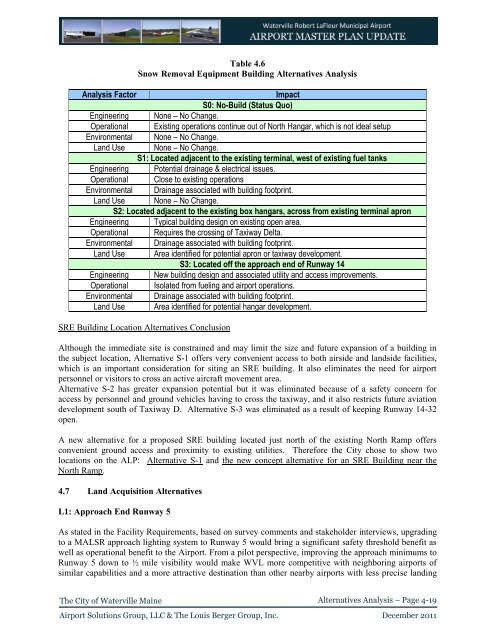
Table 4.6<br />
Snow Removal Equipment Building Alternatives Analysis<br />
Analysis Factor<br />
Impact<br />
S0: No-Build (Status Quo)<br />
Engineering None – No Change.<br />
Operational Existing operations continue out <strong>of</strong> North Hangar, which is not ideal setup<br />
Environmental None – No Change.<br />
Land Use None – No Change.<br />
S1: Located adjacent to the existing terminal, west <strong>of</strong> existing fuel tanks<br />
Engineering Potential drainage & electrical issues.<br />
Operational Close to existing operations<br />
Environmental Drainage associated with building footprint.<br />
Land Use None – No Change.<br />
S2: Located adjacent to the existing box hangars, across from existing terminal apron<br />
Engineering Typical building design on existing open area.<br />
Operational Requires the crossing <strong>of</strong> Taxiway Delta.<br />
Environmental Drainage associated with building footprint.<br />
Land Use Area identified for potential apron or taxiway development.<br />
S3: Located <strong>of</strong>f the approach end <strong>of</strong> Runway 14<br />
Engineering New building design and associated utility and access improvements.<br />
Operational Isolated from fueling and airport operations.<br />
Environmental Drainage associated with building footprint.<br />
Land Use Area identified for potential hangar development.<br />
SRE Building Location Alternatives Conclusion<br />
Although the immediate site is constrained and may limit the size and future expansion <strong>of</strong> a building in<br />
the subject location, Alternative S-1 <strong>of</strong>fers very convenient access to both airside and landside facilities,<br />
which is an important consideration for siting an SRE building. It also eliminates the need for airport<br />
personnel or visitors to cross an active aircraft movement area.<br />
Alternative S-2 has greater expansion potential but it was eliminated because <strong>of</strong> a safety concern for<br />
access by personnel and ground vehicles having to cross the taxiway, and it also restricts future aviation<br />
development south <strong>of</strong> Taxiway D. Alternative S-3 was eliminated as a result <strong>of</strong> keeping Runway 14-32<br />
open.<br />
A new alternative for a proposed SRE building located just north <strong>of</strong> the existing North Ramp <strong>of</strong>fers<br />
convenient ground access and proximity to existing utilities. Therefore the <strong>City</strong> chose to show two<br />
locations on the ALP: Alternative S-1 and the new concept alternative for an SRE Building near the<br />
North Ramp.<br />
4.7 Land Acquisition Alternatives<br />
L1: Approach End Runway 5<br />
As stated in the Facility Requirements, based on survey comments and stakeholder interviews, upgrading<br />
to a MALSR approach lighting system to Runway 5 would bring a significant safety threshold benefit as<br />
well as operational benefit to the <strong>Airport</strong>. From a pilot perspective, improving the approach minimums to<br />
Runway 5 down to ½ mile visibility would make WVL more competitive with neighboring airports <strong>of</strong><br />
similar capabilities and a more attractive destination than other nearby airports with less precise landing<br />
The <strong>City</strong> <strong>of</strong> <strong>Waterville</strong> Maine<br />
Alternatives Analysis – Page 4-19<br />
<strong>Airport</strong> Solutions Group, LLC & The Louis Berger Group, Inc. December 2011