Airport Master Plan 2012 - City of Waterville
Airport Master Plan 2012 - City of Waterville
Airport Master Plan 2012 - City of Waterville

Create successful ePaper yourself
Turn your PDF publications into a flip-book with our unique Google optimized e-Paper software.
(LAAS)). APV approach technologies include the WAAS based Localizer Performance with Vertical<br />
Guidance (LPV), Lateral Navigation/Vertical Navigation (LNAV/VNAV) and Barometric Vertical<br />
Navigation (Baro-VNAV) approaches. Non-precision approach technologies include the VHF Omnidirectional<br />
Radio Range (VOR), Non-Directional Beacon (NDB), Localizer (LOC), LDA Simplified<br />
Directional Facility (SDF) or Radio Navigation (RNAV). All <strong>of</strong> these technologies have allowed the<br />
Federal Aviation Administration (FAA) to design a variety <strong>of</strong> approach procedures to help ensure the<br />
safety <strong>of</strong> aircraft during various phases <strong>of</strong> flight and poor weather conditions.<br />
FAA funding for a new NAVAID and approach procedure is based upon demonstrating the associated<br />
need, practicality, safety benefits, and expected aviation activity at the airport. In developing a new<br />
approach procedure, the FAA considers the accuracy <strong>of</strong> the navigational aid, penetrations to the Part 77<br />
and TERPS airspace surfaces, an airport’s landing surface (runway length, lighting, markings, design<br />
criteria, etc.), and other factors as outlined in the FAA’s Advisory Circular 150/5300-13, <strong>Airport</strong> Design.<br />
It is important to note that the FAA indicates a significant reduction in minima (i.e. ¼ mile reduction in<br />
visibility and/or 50 foot reduction in decision altitude or minimum descent altitude) would constitute a<br />
new approach procedure.<br />
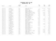
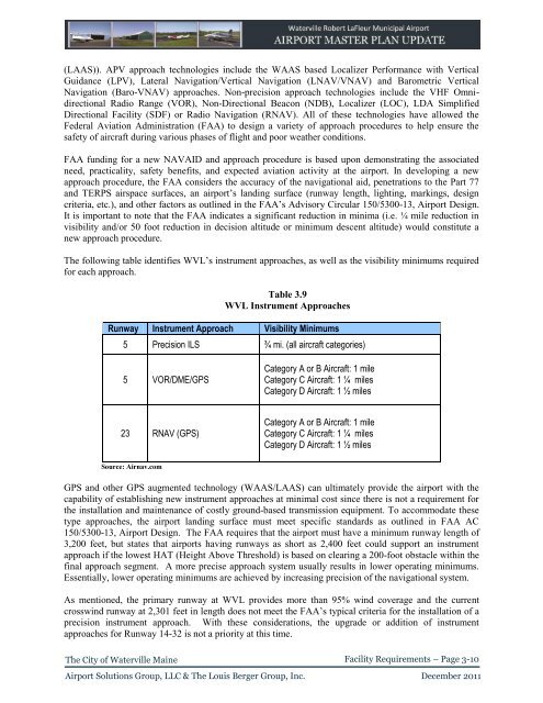
The following table identifies WVL’s instrument approaches, as well as the visibility minimums required<br />
for each approach.<br />
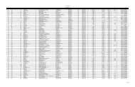
Table 3.9<br />
WVL Instrument Approaches<br />
Runway Instrument Approach Visibility Minimums<br />
5 Precision ILS ¾ mi. (all aircraft categories)<br />
5 VOR/DME/GPS<br />
Category A or B Aircraft: 1 mile<br />
Category C Aircraft: 1 ¼ miles<br />
Category D Aircraft: 1 ½ miles<br />
23 RNAV (GPS)<br />
Category A or B Aircraft: 1 mile<br />
Category C Aircraft: 1 ¼ miles<br />
Category D Aircraft: 1 ½ miles<br />
Source: Airnav.com<br />
GPS and other GPS augmented technology (WAAS/LAAS) can ultimately provide the airport with the<br />
capability <strong>of</strong> establishing new instrument approaches at minimal cost since there is not a requirement for<br />
the installation and maintenance <strong>of</strong> costly ground-based transmission equipment. To accommodate these<br />
type approaches, the airport landing surface must meet specific standards as outlined in FAA AC<br />
150/5300-13, <strong>Airport</strong> Design. The FAA requires that the airport must have a minimum runway length <strong>of</strong><br />
3,200 feet, but states that airports having runways as short as 2,400 feet could support an instrument<br />
approach if the lowest HAT (Height Above Threshold) is based on clearing a 200-foot obstacle within the<br />
final approach segment. A more precise approach system usually results in lower operating minimums.<br />
Essentially, lower operating minimums are achieved by increasing precision <strong>of</strong> the navigational system.<br />
As mentioned, the primary runway at WVL provides more than 95% wind coverage and the current<br />
crosswind runway at 2,301 feet in length does not meet the FAA’s typical criteria for the installation <strong>of</strong> a<br />
precision instrument approach. With these considerations, the upgrade or addition <strong>of</strong> instrument<br />
approaches for Runway 14-32 is not a priority at this time.<br />
The <strong>City</strong> <strong>of</strong> <strong>Waterville</strong> Maine<br />
Facility Requirements – Page 3-10<br />
<strong>Airport</strong> Solutions Group, LLC & The Louis Berger Group, Inc. December 2011