Airport Master Plan 2012 - City of Waterville
Airport Master Plan 2012 - City of Waterville
Airport Master Plan 2012 - City of Waterville

You also want an ePaper? Increase the reach of your titles
YUMPU automatically turns print PDFs into web optimized ePapers that Google loves.
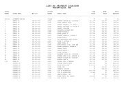
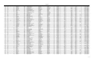
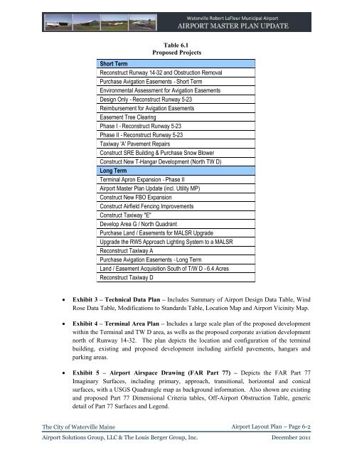
Table 6.1<br />
Proposed Projects<br />
Short Term<br />
Reconstruct Runway 14‐32 and Obstruction Removal<br />
Purchase Avigation Easements ‐ Short Term<br />
Environmental Assessment for Avigation Easements<br />
Design Only ‐ Reconstruct Runway 5‐23<br />
Reimbursement for Avigation Easements<br />
Easement Tree Clearing<br />
Phase I ‐ Reconstruct Runway 5‐23<br />
Phase II ‐ Reconstruct Runway 5‐23<br />
Taxiway 'A' Pavement Repairs<br />
Construct SRE Building & Purchase Snow Blower<br />
Construct New T‐Hangar Development (North TW D)<br />
Long Term<br />
Terminal Apron Expansion ‐ Phase II<br />
<strong>Airport</strong> <strong>Master</strong> <strong>Plan</strong> Update (incl. Utility MP)<br />
Construct New FBO Expansion<br />
Construct Airfield Fencing Improvements<br />
Construct Taxiway "E"<br />
Develop Area G / North Quadrant<br />
Purchase Land / Easements for MALSR Upgrade<br />
Upgrade the RW5 Approach Lighting System to a MALSR<br />
Reconstruct Taxiway A<br />
Purchase Avigation Easements ‐ Long Term<br />
Land / Easement Acquisition South <strong>of</strong> T/W D ‐ 6.4 Acres<br />
Reconstruct Taxiway D<br />
<br />
<br />
Exhibit 3 – Technical Data <strong>Plan</strong> – Includes Summary <strong>of</strong> <strong>Airport</strong> Design Data Table, Wind<br />
Rose Data Table, Modifications to Standards Table, Location Map and <strong>Airport</strong> Vicinity Map.<br />
Exhibit 4 – Terminal Area <strong>Plan</strong> – Includes a large scale plan <strong>of</strong> the proposed development<br />
within the Terminal and TW D area, as wells as the proposed corporate aviation development<br />
north <strong>of</strong> Runway 14-32. The plan depicts the location and configuration <strong>of</strong> the terminal<br />
building, existing and proposed development including airfield pavements, hangars and<br />
parking areas.<br />
Exhibit 5 – <strong>Airport</strong> Airspace Drawing (FAR Part 77) – Depicts the FAR Part 77<br />
Imaginary Surfaces, including primary, approach, transitional, horizontal and conical<br />
surfaces, with a USGS Quadrangle map as background information. Also shown are existing<br />
and proposed Part 77 Dimensional Criteria tables, Off-<strong>Airport</strong> Obstruction Table, generic<br />
detail <strong>of</strong> Part 77 Surfaces and Legend.<br />
The <strong>City</strong> <strong>of</strong> <strong>Waterville</strong> Maine<br />
<strong>Airport</strong> Layout <strong>Plan</strong> – Page 6-2<br />
<strong>Airport</strong> Solutions Group, LLC & The Louis Berger Group, Inc. December 2011