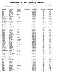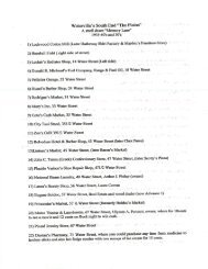
Airport Master Plan 2012 - City of Waterville
Airport Master Plan 2012 - City of Waterville
Airport Master Plan 2012 - City of Waterville

You also want an ePaper? Increase the reach of your titles
YUMPU automatically turns print PDFs into web optimized ePapers that Google loves.
minimums. However, before WVL could move forward with this upgrade, the acquisition <strong>of</strong> property <strong>of</strong>f<br />
<strong>of</strong> the approach end <strong>of</strong> Runway 5 is necessary. Figure L1 shows the limits <strong>of</strong> the inner approach OFZ<br />
(Obstacle Free Zone) surface for a future MALSR system at the Runway 5 end. Owning this area in fee<br />
simple is most desirable in order to maintain unobstructed airspace surrounding this NAVAID; however<br />
the <strong>Airport</strong> could also pursue a combination <strong>of</strong> proposed easements and property interests necessary to<br />
achieve this upgrade to the <strong>Airport</strong>‟s navigational system.<br />
L2: Northwest and North East Quadrant<br />
Regarding near and long term development for the <strong>Airport</strong>, several initial alternatives shown herein<br />
include scenarios in which land acquisition is necessary should they be determined as “preferred”<br />
alternatives.<br />
Alternative T1c shows an extension <strong>of</strong> Taxiway “B” leading directly to the current terminal apron area<br />
and Alternative H3 suggests expanding the development <strong>of</strong> the exiting box hangars to the southeast; these<br />
alternatives can only occur if the <strong>Airport</strong> were to acquire property in the southwest quadrant <strong>of</strong> the<br />
<strong>Airport</strong>. This triangular area can be seen on Figure L2.<br />
Although it is suggested that initial airport development should occur in the southwest quadrant <strong>of</strong> the<br />
<strong>Airport</strong>, it is still important to look beyond the near term for airport development opportunities. As shown<br />
in Alternative H7, the northwest quadrant <strong>of</strong> the <strong>Airport</strong>, adjacent to the old Telford hangar, may allow<br />
for significant additional long term development. However, in order to proceed with any development<br />
initiatives such as H7 that are west <strong>of</strong> the old Telford apron, the <strong>Airport</strong> would need to acquire the land in<br />
the northwest quadrant. This is also shown on Figure L2.<br />
Land Acquisition Conclusion<br />
Alternative L-1 is consistent with previous recommendations from this study for obtaining better<br />
instrument approach procedures; a new MALSR system is one way to achieve this goal. Both components<br />
<strong>of</strong> Alternative L-2 are necessary to achieve previously recommended alternatives. Therefore, the <strong>City</strong><br />
chose to include all three alternatives on the ALP.<br />
The following pages include the Alternatives Figures referenced herein.<br />
The <strong>City</strong> <strong>of</strong> <strong>Waterville</strong> Maine<br />
Alternatives Analysis – Page 4-20<br />
<strong>Airport</strong> Solutions Group, LLC & The Louis Berger Group, Inc. December 2011