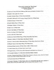
Airport Master Plan 2012 - City of Waterville
Airport Master Plan 2012 - City of Waterville
Airport Master Plan 2012 - City of Waterville

You also want an ePaper? Increase the reach of your titles
YUMPU automatically turns print PDFs into web optimized ePapers that Google loves.
foot for every seven feet moved horizon-tally)<br />
from the Primary Surface and Approach Surface<br />
defined in Federal Aviation Regulations (FAR)<br />
Part 77.<br />
TURBINE - A mechanical device or engine that<br />
spins in reaction to fluid flow through or over it.<br />
This device is used in turb<strong>of</strong>an, turbojet, and<br />
turboprop-powered aircraft.<br />
TURBOFAN - A turbojet engine whose thrust<br />
has been increased by the addition <strong>of</strong> a lowpressure<br />
compressor fan.<br />
TURBOJET - An engine that derives power<br />
from a fanned wheel spinning in reaction to<br />
burning gases escaping from a combustion<br />
chamber. The turbine in turn drives a<br />
compressor and other accessories.<br />
TURBOPROP - A turbine engine in which the<br />
rotating turbine turns a propeller.<br />
UTILITY AIRPORT - A utility airport is an<br />
airport designed, constructed, and maintained to<br />
serve airplanes in Aircraft Approach Category A<br />
and B. For discussion on airport type, see<br />
paragraph 5.<br />
VFR CONDITIONS - Basic weather<br />
conditions prescribed for flight under Visual<br />
Flight Rules; usually implies a ceiling <strong>of</strong> at least<br />
1000 feet and a forward visibility <strong>of</strong> three miles<br />
or more.<br />
VERY HIGH FREQUENCY OMNI<br />
DIRECTIONAL RANGE (VOR) - A ground<br />
radio station that provides a pilot <strong>of</strong> a properly<br />
equipped air-craft with his radial location in<br />
reference to that station. A VORTAC is an<br />
electronic air navigation facility combining a<br />
VOR and a TACAN.<br />
VISIBILITY, PREVAILING - The horizontal<br />
distance at which targets <strong>of</strong> known distance are<br />
visible over at least half <strong>of</strong> the horizon. It is<br />
normally determined by an observer on or close<br />
to the ground viewing buildings or other similar<br />
objects during the day and ordinary city lights at<br />
night.<br />
VISUAL APPROACH SLOPE INDICATOR<br />
(VASI) - The VASI is a device used by pilots to<br />
determine their position in regard to the<br />
recommended approach path for a particular<br />
airport. See also GVGI.<br />
VISUAL FLIGHT RULES (VFR) - "See and<br />
be seen" flight rules. Each pilot is responsible<br />
for the safe spacing and proper operation <strong>of</strong> his<br />
aircraft. Under VFR, a pilot is not required to<br />
file a flight plan or be in constant radar and<br />
communication contact with air traffic control.<br />
Visual flight rules are determined by weather<br />
and require a ceiling <strong>of</strong> at least 1,000 feet and<br />
visibility <strong>of</strong> at least 3 miles.<br />
VFR TRAFFIC - Aircraft traffic operated<br />
solely in accordance with Visual Flight Rules.<br />
VISUAL APPROACH - A VFR approach<br />
granted to an IFR flight by air traffic control<br />
under special circumstances. Visual approaches<br />
are normally conducted by aircraft operating<br />
under visual flight rules.<br />
VISUAL RUNWAY - A visual runway is a<br />
runway intended solely for the operation <strong>of</strong><br />
aircraft using visual approach procedures, with<br />
no straight-in instrument approach procedure<br />
and no instrument designation indicated on an<br />
FAA or Department <strong>of</strong> Defense (DOD)<br />
approved layout plan, or, on other FAA or DOD<br />
planning documents.<br />
VORTAC - A combination <strong>of</strong> the civil<br />
VOR/DME and the military TACAN which can<br />
provide both distance and direction <strong>of</strong> an aircraft<br />
from the station.<br />
WAKE TURBULENCE - The air turbulence<br />
caused by a moving aircraft, originating at the<br />
tips <strong>of</strong> the wings. The turbulence is caused by<br />
vortices generated by an aircraft’s wingtips as it<br />
travels through the air. This turbulence is<br />
greatest when the aircraft is taking <strong>of</strong>f and<br />
landing.<br />
WIND COVERAGE - Wind coverage is the<br />
percent <strong>of</strong> time for which aeronautical<br />
operations are considered safe due to acceptable<br />
crosswind components.<br />
The <strong>City</strong> <strong>of</strong> <strong>Waterville</strong> Maine<br />
Appendix A - Glossary – Page 1-8<br />
<strong>Airport</strong> Solutions Group, LLC & The Louis Berger Group, Inc. December 2011