Airport Master Plan 2012 - City of Waterville
Airport Master Plan 2012 - City of Waterville
Airport Master Plan 2012 - City of Waterville
You also want an ePaper? Increase the reach of your titles
YUMPU automatically turns print PDFs into web optimized ePapers that Google loves.
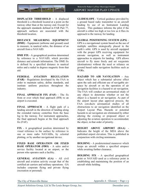
DISPLACED THRESHOLD - A displaced<br />
threshold is a threshold located at a point on the<br />
runway other than at the runway end. Except for<br />
the approach standards defined in FAR Part 77,<br />
approach surfaces are associated with the<br />
threshold location.<br />
DISTANCE MEASURING EQUIPMENT<br />
(DME) - Equipment (airborne and ground) used<br />
to measure, in nautical miles, the distance <strong>of</strong> an<br />
aircraft from a NAVAID.<br />
DME FIX - A geographical position determined<br />
by reference to a NAVAID, which provides<br />
distance and azimuth information. The DME fix<br />
is defined by a specified distance in nautical<br />
miles and a radial in degrees magnetic from that<br />
aid.<br />
FEDERAL AVIATION REGULATION<br />
(FAR) - Regulations developed by the FAA in<br />
order to maintain safety, define standards, and<br />
institute uniform practices throughout the<br />
industry.<br />
FINAL APPROACH FIX (FAF) - The fix<br />
from or over which final approach (IFR) to an<br />
airport is executed.<br />
FINAL APPROACH - A flight path <strong>of</strong> a<br />
landing aircraft in the direction <strong>of</strong> landing along<br />
the extended runway centerline from the base<br />
leg to the runway. For instrument approaches,<br />
the final approach begins at the final approach<br />
fix (FAF).<br />
FIX - A geographical position determined by<br />
visual reference to the surface by reference to<br />
one or more radio NAVAIDs, by celestial<br />
plotting, or by another navigational device.<br />
FIXED BASE OPERATION OR FIXED<br />
BASE OPERATOR (FBO) - A sales and/or<br />
service facility located at an airport, or the<br />
person who operates such a facility.<br />
GENERAL AVIATION (GA) - All civil<br />
aircraft and aviation activity except that <strong>of</strong> the<br />
certified air carriers and military operations. GA<br />
includes corporate flying and private flying<br />
(recreation or personal).<br />
GLIDESLOPE - Vertical guidance provided by<br />
a ground based radio transmitter to an aircraft<br />
landing by use <strong>of</strong> an Instrument Landing<br />
System. This guidance informs the pilot if the<br />
aircraft is either too high or too low as it flies its<br />
approach to the runway for landing.<br />
GLOBAL POSITIONING SYSTEM (GPS) -<br />
GPS is a navigational system based on the use <strong>of</strong><br />
multiple satellites strategically placed in the<br />
earth’s orbit. GPS is used by aircraft equipped<br />
with the proper GPS receiving equipment for<br />
enroute navigation, as well as instrument<br />
approaches to airports for landing. GPS allows<br />
aircraft to fly more freely and set waypoints<br />
(destinations) without the need or reliance on<br />
ground based radio navigation facilities such as<br />
VORs.<br />
HAZARD TO AIR NAVIGATION - Any<br />
object which has a substantial adverse effect<br />
upon the safe and efficient use <strong>of</strong> navigable airspace<br />
by aircraft or on the operation <strong>of</strong> air<br />
navigation facilities is a hazard to air navigation.<br />
The FAA will conduct an aeronautical study <strong>of</strong><br />
any object to determine whether or not the<br />
object is a hazard to air navigation. As part <strong>of</strong><br />
the airport layout plan approval process, the<br />
FAA con-ducts aeronautical studies <strong>of</strong> all<br />
obstructions to air navigation identified on the<br />
<strong>Airport</strong> Layout <strong>Plan</strong>. Hazards or potential<br />
hazards to air navigation are eliminated by either<br />
altering the existing or proposed object or<br />
adjusting the aviation operation to accommodate<br />
the object, in that order <strong>of</strong> priority.<br />
HEIGHT ABOVE AIRPORT (HAA) -<br />
Indicates the height <strong>of</strong> the MDA above the<br />
published airport elevation. This is published in<br />
conjunction with circling minimums.<br />
HOLDING - A predetermined maneuver which<br />
keeps an aircraft within a specified airspace<br />
while awaiting further clearance.<br />
HOLDING FIX - A specified geographical<br />
point or NAVAID used as a reference point in<br />
establishing and maintaining the position <strong>of</strong> an<br />
aircraft while holding.<br />
The <strong>City</strong> <strong>of</strong> <strong>Waterville</strong> Maine<br />
Appendix A - Glossary – Page 1-3<br />
<strong>Airport</strong> Solutions Group, LLC & The Louis Berger Group, Inc. December 2011


