Draft National Wind Farm Development Guidelines - July 2010
Draft National Wind Farm Development Guidelines - July 2010
Draft National Wind Farm Development Guidelines - July 2010

You also want an ePaper? Increase the reach of your titles
YUMPU automatically turns print PDFs into web optimized ePapers that Google loves.
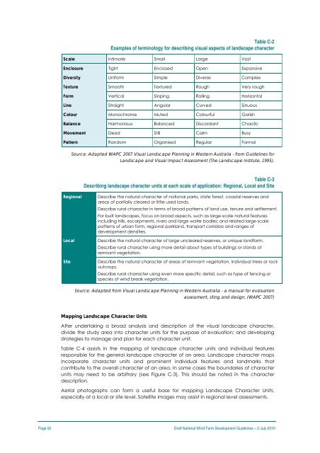
Table C-2<br />
Examples of terminology for describing visual aspects of landscape character<br />
Scale Intimate Small Large Vast<br />
Enclosure Tight Enclosed Open Expansive<br />
Diversity Uniform Simple Diverse Complex<br />
Texture Smooth Textured Rough Very rough<br />
Form Vertical Sloping Rolling Horizontal<br />
Line Straight Angular Curved Sinuous<br />
Colour Monochrome Muted Colourful Garish<br />
Balance Harmonious Balanced Discordant Chaotic<br />
Movement Dead Still Calm Busy<br />
Pattern Random Organised Regular Formal<br />
Source: Adapted WAPC 2007 Visual Landscape Planning in Western Australia - from <strong>Guidelines</strong> for<br />
Landscape and Visual Impact Assessment (The Landscape Institute, 1995).<br />
Table C-3<br />
Describing landscape character units at each scale of application: Regional, Local and Site<br />
Regional<br />
Local<br />
Site<br />
Describe the natural character of national parks, state forest, coastal reserves and<br />
areas of partially cleared or little used lands.<br />
Describe rural character in terms of broad patterns of land use, tenure and settlement.<br />
For built landscapes, focus on broad aspects, such as large-scale natural features<br />
including hills, escarpments, rivers and large water bodies; and related large-scale<br />
patterns of urban form, regional parkland, transport corridors and ranges of<br />
development densities.<br />
Describe the natural character of large uncleared reserves, or unique landform.<br />
Describe rural character using more detail about types of buildings or stands of<br />
remnant vegetation.<br />
Describe the natural character of areas of remnant vegetation, individual trees or rock<br />
outcrops.<br />
Describe rural character using even more specific detail, such as type of fencing or<br />
species of wind break vegetation.<br />
Source: Adapted from Visual Landscape Planning in Western Australia - a manual for evaluation<br />
assessment, siting and design, (WAPC 2007)<br />
Mapping Landscape Character Units<br />
After undertaking a broad analysis and description of the visual landscape character,<br />
divide the study area into character units for the purpose of evaluation; and developing<br />
strategies to manage and plan for each character unit.<br />
Table C-4 assists in the mapping of landscape character units and individual features<br />
responsible for the general landscape character of an area. Landscape character maps<br />
incorporate character units and prominent individual features and landmarks that<br />
contribute to the overall character of an area. In some cases the boundaries of character<br />
units may need to be arbitrary (see Figure C-3). This should be noted in the character<br />
description.<br />
Aerial photographs can form a useful base for mapping Landscape Character Units,<br />
especially at a local or site level. Satellite images may assist in regional level assessments.<br />
Page 92 <strong>Draft</strong> <strong>National</strong> <strong>Wind</strong> <strong>Farm</strong> <strong>Development</strong> <strong>Guidelines</strong> – 2 <strong>July</strong> <strong>2010</strong>