- Page 1 and 2: The Minister of the Environment and
- Page 3 and 4: February 2004 Contents List of Appe
- Page 5 and 6: February 2004 2.5 Sustainable Fores
- Page 7 and 8: February 2004 17. Macromycettes of
- Page 9 and 10: February 2004 List of Abbreviations
- Page 11 and 12: February 2004 MV Motor Vehicles NAT
- Page 13 and 14: February 2004 Glossary of professio
- Page 15 and 16: February 2004 extent or playing a s
- Page 17 and 18: February 2004 and included in the w
- Page 19 and 20: February 2004 Brown-Blanque School
- Page 21 and 22: February 2004 assistance the latest
- Page 23 and 24: February 2004 and the state institu
- Page 25 and 26: February 2004 Conservation signific
- Page 27 and 28: February 2004 The Management Plan a
- Page 29 and 30: February 2004 (Nature Park) in the
- Page 31 and 32: February 2004 Creative Group, the U
- Page 33 and 34: February 2004 Subcontractors to the
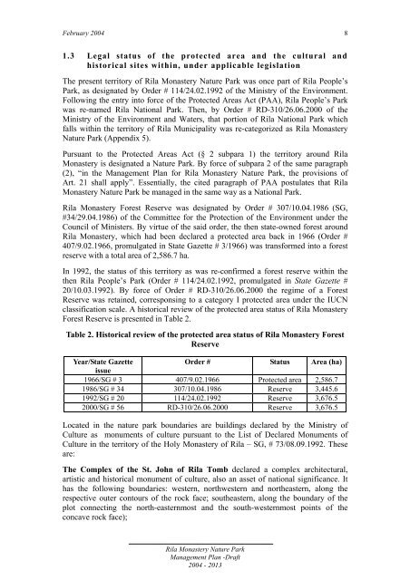
- Page 35 and 36: February 2004 1.0 General informati
- Page 37 and 38: February 2004 (Manastirska). The Re
- Page 39: February 2004 Administratively, Ril
- Page 43 and 44: February 2004 Table 4: Distribution
- Page 45 and 46: February 2004 Cultures Act. EFACA c
- Page 47 and 48: February 2004 facilities, restauran
- Page 49 and 50: February 2004 According to FI 2000,
- Page 51 and 52: February 2004 affect the water outl
- Page 53 and 54: February 2004 2.0 Description of ab
- Page 55 and 56: February 2004 2.1.4 Solar radiation
- Page 57 and 58: February 2004 There is a clearly de
- Page 59 and 60: February 2004 In the granites of th
- Page 61 and 62: February 2004 height, reaching towa
- Page 63 and 64: February 2004 Periglacial relief It
- Page 65 and 66: February 2004 in a westward directi
- Page 67 and 68: February 2004 Ribni Lakes and the t
- Page 69 and 70: February 2004 2.3.5 River water qua
- Page 71 and 72: February 2004 The above-cited findi
- Page 73 and 74: February 2004 2.4.2 Soil erosion In
- Page 75 and 76: February 2004 Ecosystems of the tre
- Page 77 and 78: February 2004 The alpine treeless z
- Page 79 and 80: February 2004 The following territo
- Page 81 and 82: February 2004 Table 11: Distributio
- Page 83 and 84: February 2004 Distribution of fores
- Page 85 and 86: February 2004 Table 19: Distributio
- Page 87 and 88: February 2004 photophilic character
- Page 89 and 90: February 2004 брой видове
- Page 91 and 92:
February 2004 protoroburoides). The
- Page 93 and 94:
February 2004 number species 800 60
- Page 95 and 96:
February 2004 Group IV The fourth g
- Page 97 and 98:
February 2004 Of the highest conser
- Page 99 and 100:
February 2004 alpine zone. The larg
- Page 101 and 102:
February 2004 Neuroptera: Libelloid
- Page 103 and 104:
February 2004 that can be encounter
- Page 105 and 106:
February 2004 European, and 151 of
- Page 107 and 108:
February 2004 B. Species endangered
- Page 109 and 110:
February 2004 its annexes. Of these
- Page 111 and 112:
February 2004 to the Directive on H
- Page 113 and 114:
February 2004 4.0 Cultural and Soci
- Page 115 and 116:
February 2004 The residence of Arch
- Page 117 and 118:
February 2004 Infrastructure relate
- Page 119 and 120:
February 2004 Table 22: General inf
- Page 121 and 122:
February 2004 Dairy farming was ano
- Page 123 and 124:
February 2004 leaves for fodder. Th
- Page 125 and 126:
February 2004 According to data fro
- Page 127 and 128:
February 2004 awe and fascination w
- Page 129 and 130:
February 2004 % 100 Rila Monastery
- Page 131 and 132:
February 2004 Hiking and mountain c
- Page 133 and 134:
February 2004 Type/name of the faci
- Page 135 and 136:
February 2004 Type/name of the faci
- Page 137 and 138:
February 2004 4.1.8 Public awarenes
- Page 139 and 140:
February 2004 or emergency, since t
- Page 141 and 142:
February 2004 Monastery Forest Rese
- Page 143 and 144:
February 2004 The BAS Institute of
- Page 145 and 146:
February 2004 The average annual wa
- Page 147 and 148:
February 2004 Table 29: List of the
- Page 149 and 150:
February 2004 Dependence of the pop
- Page 151 and 152:
February 2004 includes the followin
- Page 153 and 154:
February 2004 Such proximity enable
- Page 155 and 156:
February 2004 (living quarters) are
- Page 157 and 158:
February 2004 The St. Luke Hermitag
- Page 159 and 160:
February 2004 On the whole, both va
- Page 161 and 162:
February 2004 round qualities, func
- Page 163 and 164:
February 2004 5.0 First assessment:
- Page 165 and 166:
February 2004 - breeding ground of
- Page 167 and 168:
February 2004 The proposed sustaina
- Page 169 and 170:
February 2004 Non-timber natural re
- Page 171 and 172:
February 2004 Tourism Tourism is on
- Page 173 and 174:
February 2004 Transportation expens
- Page 175 and 176:
February 2004 1.0 Ideal (long-term)
- Page 177 and 178:
February 2004 populations (reintrod
- Page 179 and 180:
February 2004 1.5 Interpretation an
- Page 181 and 182:
February 2004 roads, hydro technica
- Page 183 and 184:
February 2004 (a similar process ha
- Page 185 and 186:
February 2004 2.2 Anthropogenic thr
- Page 187 and 188:
February 2004 Similar in its destru
- Page 189 and 190:
February 2004 Increased tourist pre
- Page 191 and 192:
February 2004 Pollution with solid
- Page 193 and 194:
February 2004 overuse of non-timber
- Page 195 and 196:
February 2004 2.3 Limitations The l
- Page 197 and 198:
February 2004 The presence of a set
- Page 199 and 200:
February 2004 The impact of threats
- Page 201 and 202:
February 2004 4.2 Conservation of n
- Page 203 and 204:
February 2004 Long-term goal 4.2.5
- Page 205 and 206:
February 2004 • To implement a pr
- Page 207 and 208:
February 2004 - To develop and impl
- Page 209 and 210:
February 2004 1.0 General Regimes a
- Page 211 and 212:
February 2004 1.1.2. Pursuant to PA
- Page 213 and 214:
February 2004 2.0 Zones, Regimes an
- Page 215 and 216:
February 2004 Purpose of the Buffer
- Page 217 and 218:
February 2004 Description, physical
- Page 219 and 220:
February 2004 Purpose of the Enviro
- Page 221 and 222:
February 2004 2.4 The Technical Inf
- Page 223 and 224:
February 2004 2.5 The Sustainable F
- Page 225 and 226:
February 2004 Conditions 1. The Sus
- Page 227 and 228:
February 2004 2.7 The Tourism Zone
- Page 229 and 230:
February 2004 1. Construction of an
- Page 231 and 232:
February 2004 1. Building and diffe
- Page 233 and 234:
February 2004 - Tiha Rila - Lake Sm
- Page 235 and 236:
PART IV OPERATIONAL/WORK PLAN
- Page 237 and 238:
February 2004 facilities in the par
- Page 239 and 240:
February 2004 natural environment.
- Page 241 and 242:
February 2004 natural re-growth of
- Page 243 and 244:
February 2004 • Project: Restorat
- Page 245 and 246:
February 2004 supporting and ensuri
- Page 247 and 248:
February 2004 2.4 Management of tou
- Page 249 and 250:
February 2004 • Project: Setting
- Page 251 and 252:
February 2004 • Project: Involvem
- Page 253 and 254:
February 2004 • Project: Building
- Page 255 and 256:
February 2004 2.7.8 Program for pro
- Page 257 and 258:
February 2004 Contractor Duration C
- Page 259 and 260:
February 2004 Contractor Duration C
- Page 261 and 262:
February 2004 Contractor Duration C
- Page 263 and 264:
PART V MONITORING OF THE IMPLEMENTA
- Page 265 and 266:
February 2004 1.2.2 Revising the Ma
- Page 267 and 268:
February 2004 Bibliography A classi
- Page 269 and 270:
February 2004 Hilton-taylor, C. - c
- Page 271 and 272:
February 2004 Simeonovski, М. 1965
- Page 273 and 274:
APPENDICES
- Page 275 and 276:
February 2004 Environment Protectio
- Page 277 and 278:
February 2004 Order No. 114 Dated F
- Page 279 and 280:
February 2004 II. High mountain pas
- Page 281 and 282:
February 2004 The Reserve shall inc
- Page 283 and 284:
February 2004 Appendix 3 List of in
- Page 285 and 286:
February 2004 Appendix 3 Object typ
- Page 287 and 288:
February 2004 Appendix 3 Object typ
- Page 289 and 290:
February 2004 Appendix 3 Object typ
- Page 291 and 292:
February 2004 Appendix 3 Object typ
- Page 293 and 294:
February 2004 Appendix 3 Object typ
- Page 295 and 296:
February 2004 Appendix 3 List of ab
- Page 297 and 298:
February 2004 Rila Monastery Nature
- Page 299 and 300:
February 2004 133 - а, и, к, л,
- Page 301 and 302:
February 2004 а, б, в, г, д, 1
- Page 303 and 304:
February 2004 ZONE B The Zone B reg
- Page 305 and 306:
February 2004 Ministry of Environme
- Page 307 and 308:
February 2004 List of the Documents
- Page 309 and 310:
February 2004 No Institution Contac
- Page 311 and 312:
February 2004 Appendix 8 Geological
- Page 313 and 314:
February 2004 Appendix 8 Geological
- Page 315 and 316:
February 2004 Appendix 8 Geological
- Page 317 and 318:
February 2004 Appendix 10 No Code L
- Page 319 and 320:
February 2004 Appendix 10 43 37.872
- Page 321 and 322:
February 2004 Appendix 11 Station N
- Page 323 and 324:
February 2004 Appendix 11 Station N
- Page 325 and 326:
February 2004 Appendix 13 List of h
- Page 327 and 328:
February 2004 Appendix 13 No Taxon
- Page 329 and 330:
February 2004 Appendix 13 No Taxon
- Page 331 and 332:
February 2004 Appendix 13 No Taxon
- Page 333 and 334:
February 2004 Appendix 13 No Taxon
- Page 335 and 336:
February 2004 Appendix 13 No Taxon
- Page 337 and 338:
February 2004 No Taxa Species diver
- Page 339 and 340:
February 2004 No Taxons Established
- Page 341 and 342:
February 2004 No Taxons Established
- Page 343 and 344:
February 2004 Appendix 15 Endemic N
- Page 345 and 346:
February 2004 Appendix 15 Endemic N
- Page 347 and 348:
February 2004 Appendix 15 Key: Ende
- Page 349 and 350:
February 2004 No Species 26. Thymus
- Page 351 and 352:
February 2004 List of edible mushro
- Page 353 and 354:
February 2004 Appendix 19 Endemic N
- Page 355 and 356:
February 2004 Appendix 19 No Taxon
- Page 357 and 358:
February 2004 Appendix 19 No Taxon
- Page 359 and 360:
February 2004 Appendix 19 Endemic N
- Page 361 and 362:
February 2004 Appendix 19 Endemic N
- Page 363 and 364:
February 2004 Appendix 19 No Taxon
- Page 365 and 366:
February 2004 Appendix 20 List of v
- Page 367 and 368:
February 2004 Appendix 20 No Taxon
- Page 369 and 370:
February 2004 Appendix 20 No Taxon
- Page 371 and 372:
February 2004 Appendix 20 No Taxon
- Page 373 and 374:
February 2004 Appendix 20 Key: Ende
- Page 375 and 376:
February 2004 Rila Monastery Nature
- Page 377 and 378:
February 2004 Common species Number
- Page 379 and 380:
February 2004 Rila Monastery Nature
- Page 381 and 382:
February 2004 Crafts Fulling mill,
- Page 383 and 384:
February 2004 Auxiliary infrastruct
- Page 385 and 386:
February 2004 Handling of fecal was
- Page 387 and 388:
February 2004 Auxiliary infrastruct
- Page 389 and 390:
February 2004 Appendix 24 Natural P
- Page 391 and 392:
February 2004 405 Rila Monastery Na
- Page 393 and 394:
Form No February 2004 Appendix 27 S
- Page 395 and 396:
Form No February 2004 Appendix 27 3
- Page 397 and 398:
Form No Studied area February 2004
- Page 399 and 400:
Form No Studied area February 2004
- Page 401 and 402:
February 2004 416 The paths of thes
- Page 403 and 404:
February 2004 418 4. Ribni lakes ch
- Page 405 and 406:
February 2004 Appendix 31 Goal Perf
- Page 407 and 408:
February 2004 Appendix 31 Goals Ind
- Page 409 and 410:
February 2004 Appendix 31 Goals Ind
- Page 411 and 412:
February 2004 Appendix 31 Goals Ind
- Page 413 and 414:
February 2004 Appendix 31 Goals Ind
- Page 415 and 416:
February 2004 Appendix 31 Goals Ind
- Page 417 and 418:
February 2004 Appendix 31 Goals par
- Page 419 and 420:
February 2004 Appendix 31 Goals Ind
- Page 421:
February 2004 Rila Monastery Nature
- Page 425:
February 2004 Rila Monastery Nature
- Page 429:
February 2004 Rila Monastery Nature
- Page 432:
February 2004 9. 36.3921 Oro-Moesia
- Page 436:
February 2004 Rila Monastery Nature
- Page 440 and 441:
February 2004 Rila Monastery Nature
- Page 443:
February 2004 Rila Monastery Nature
- Page 447:
February 2004 Rila Monastery Nature