

Download the entire proceedings as an Adobe PDF - Eastern Snow ...
Download the entire proceedings as an Adobe PDF - Eastern Snow ...
Download the entire proceedings as an Adobe PDF - Eastern Snow ...

Create successful ePaper yourself
Turn your PDF publications into a flip-book with our unique Google optimized e-Paper software.
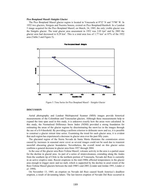
Pico Bonpl<strong>an</strong>d M<strong>as</strong>sif–Sinigüis Glacier<br />
The Pico Bonpl<strong>an</strong>d M<strong>as</strong>sif glacier region is located in Venezuela at 8º32′ N <strong>an</strong>d 71º00′ W. In<br />
1952 two glaciers, Siniguis <strong>an</strong>d Nuestra Senora, existed on Pico Bonpl<strong>an</strong>d/Humbolt. In a L<strong>an</strong>dsat<br />
5 image acquired for <strong>the</strong> Pico Bonpl<strong>an</strong>d M<strong>as</strong>sif, on March, 24, 1985, <strong>the</strong> only visible glacier w<strong>as</strong><br />
<strong>the</strong> Sinigüis glacier. The total glacier area <strong>as</strong>sessment in 1952 w<strong>as</strong> 2.03 km 2 <strong>an</strong>d by 2003 <strong>the</strong><br />
glacier area had decre<strong>as</strong>ed to 0.29 km 2 . This is a total area loss of 1.77 km 2 or 87% of <strong>the</strong> 1952<br />
area (Table 3 <strong>an</strong>d Figure 5).<br />
DISCUSSION<br />
Figure 5. Time Series for Pico Bonpl<strong>an</strong>d M<strong>as</strong>sif – Sinigüis Glacier<br />
Aerial photography <strong>an</strong>d L<strong>an</strong>dsat Multispectral Sc<strong>an</strong>ner (MSS) images provide historical<br />
me<strong>as</strong>urements of <strong>the</strong> Colombi<strong>an</strong> <strong>an</strong>d Venezuel<strong>an</strong> glaciers. Although <strong>the</strong>se me<strong>as</strong>urements help to<br />
exp<strong>an</strong>d <strong>the</strong> time sp<strong>an</strong> used in this study, it is unknown exactly how <strong>the</strong> are<strong>as</strong> were calculated. In<br />
this study, <strong>the</strong> Normalized Difference <strong>Snow</strong> Index (NDSI) provided a strong foundation for<br />
estimating <strong>the</strong> are<strong>as</strong> of <strong>the</strong> glacier regions by discriminating <strong>the</strong> snow/ice in <strong>the</strong> images through<br />
<strong>the</strong> use of a 0.4 threshold. By providing a uniform criterion to delineate snow <strong>an</strong>d ice, it is possible<br />
to construct a glacier retreat time series. Examining <strong>the</strong> trend for each glacier area, it is evident<br />
that each region h<strong>as</strong> experienced a decre<strong>as</strong>e in glacier area over <strong>the</strong> p<strong>as</strong>t fifty years.<br />
The glaciated region of <strong>the</strong> Sierra Nevada de S<strong>an</strong>ta Marta illustrates <strong>the</strong> commission errors<br />
caused by incre<strong>as</strong>es in se<strong>as</strong>onal snow cover <strong>as</strong> several images could not be used due to tr<strong>an</strong>sient<br />
snowfall obscuring glacier boundaries. Never<strong>the</strong>less, <strong>the</strong> overall trend on this glacier series<br />
confirms a general decre<strong>as</strong>e in glacier area from 1957 through 2004.<br />
In <strong>the</strong> c<strong>as</strong>e of <strong>the</strong> glacier area Ruiz-Tolima M<strong>as</strong>sif, volc<strong>an</strong>ic activity in <strong>the</strong> area is a partial cause<br />
for <strong>the</strong> decline in glacial area. As part of a series of stratovolc<strong>an</strong>oes, extending along <strong>the</strong> Andes<br />
from <strong>the</strong> sou<strong>the</strong>rn tip of Chile to <strong>the</strong> nor<strong>the</strong>rn portion of Venezuela, Nevado del Ruiz is currently<br />
in <strong>an</strong> active eruptive state. Recent eruptions in <strong>the</strong> mid-1980s affected temperatures in <strong>the</strong> glacier<br />
area enough to trigger snow <strong>an</strong>d ice melt, which is supported by <strong>the</strong> decline in areal extent of <strong>the</strong><br />
Ruiz-Tolima M<strong>as</strong>sif glaciers between <strong>the</strong> mid-1980’s <strong>an</strong>d 2001 (Linder <strong>an</strong>d Jord<strong>an</strong> 1991, Linder et<br />
al. 1994).<br />
On November 13, 1985, <strong>an</strong> eruption on Nevado del Ruiz caused South America’s deadliest<br />
eruption, a result of dev<strong>as</strong>tating lahars. The l<strong>as</strong>t known eruption of Nevado Del Ruiz occurred in<br />
189


