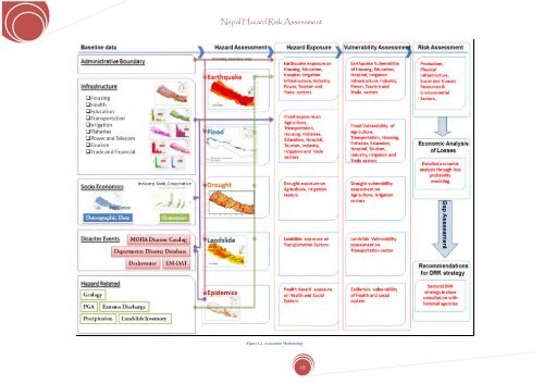
<strong>Nepal</strong> <strong>Hazard</strong> <strong>Risk</strong> <strong>Assessment</strong> Figure 1.2. <strong>Assessment</strong> Methodology 18
<strong>Nepal</strong> <strong>Hazard</strong> <strong>Risk</strong> <strong>Assessment</strong> 2 BASELINE DATA AND INFORMATION 2.1 NATURAL DISASTER PROFILE OF NEPAL Unstable steep slopes and fragile geological <strong>for</strong>mation of a young growing mountain range with heavy monsoon rainfall leads to wide range of geological and hydro-meteorological disasters across the country. <strong>Nepal</strong> is divided into three major region having mountains, hills and terai. Each region is distinct to it characteristics. The variation in geological characteristics together with torrential rain during rainy season result to landslides, debris flows, floods, and earthquakes. Apart from these disasters, there are several other manmade disasters reported in the country. After instatement of peace process in the country, <strong>Nepal</strong> is leading to the progressive development. In this juncture, there is a dire need to understand the characteristics of existing hazards and establish national disaster risk management plan <strong>for</strong> sustained development. 2.1.1 EARTHQUAKE HAZARDS <strong>Nepal</strong> is having long history of earthquake activities due to its location on a tectonic active zone. The presence of three main fault lines (ICIMOD, 2007): the main central thrust (MCT) at the foot of the greater Himalaya joining the midland mountains, the main boundary fault (MBF) at the junction of the lesser Himalaya, and the Siwalik and the Himalaya frontal Fault south of the Siwalik, each running east to west, are causes of earthquakes of small and greater magnitude in <strong>Nepal</strong>. These fault lines are result of the movement of the Indian plate under the Eurasian Plate. Several Major earthquakes were reported in 1255 AD, 1810 AD, 1866 AD, 1934AD, 1980 AD and 1988 AD in <strong>Nepal</strong>. The 1934 earthquake largely impacted the Kathmandu city resulted in more than 8500 deaths. More than 38,000 collapsed buildings. This earthquake was well reported by several scholars. One of the detailed studies may be referred in Field Memoir published by Geological Survey of India (Jain, 1998). 2.1.2 RIVERINE AND FLASH FLOODS Rainfall during the monsoon season is caused by the influence of both the south-east and south-west Monsoon, characterized by intense rainfall during the four months from June to September, contributing to 80% of the rainfall. During the monsoon, rivers originating from the Mahabharat range; viz., the Kankai, Kamal, Bangmati, West Rapti and Babai causes greater damage in floodplains of Terai region. Riverine floods from the major perennial rivers generally rise slowly in the southern Terai plains. Inundations of large areas are due to overflowing river banks resulting in extensive damage to life and properties. debris, ice, or snow. Water flow in the rivers in the Siwalik range in southern <strong>Nepal</strong> are characterised by a sharp rise of flood water followed by a rapid recession, often causing high flow velocities, resulting in damage crops, property, lives, and livelihoods. Damming of a river by a landslide is a potentially dangerous situation. Such a blockage of the river flow is more common in narrow valleys where the slopes are steep on both sides of the river. Landslide dams will eventually collapse, causing heavy downstream flooding resulting in loss of life and property. Glacial lakes are common in the high altitude areas of the country. These lakes often contain huge volume of water. The lakes are dammed behind moraine ridges which are stable depending on the amount of ice within these ridges; and their unstable condition may lead to a breakage of the same, creating a Glacial Lake Outburst Flood (GLOF) with the potential to cause great damage downstream. Altogether 2,315 glacial lakes have been identified in <strong>Nepal</strong> and about 14 GLOFs recorded to have occurred between 1935 and 1991 in <strong>Nepal</strong> (ICIMOD, 2007). In total, 20 glacial lakes have been identified as being potentially dangerous at present. 2.1.3 DROUGHT <strong>Nepal</strong> is experiencing a rapidly worsening drought, caused by erratic rainfall in summer and an almost total lack of rainfall during winter. Some studies of past drought suggest that unusual events were randomly found in the country’s historical records. During present decade almost each year, at least few parts of the country experience either a short or long dry period even within the wet season (DHM, 2001-2009). As <strong>for</strong> example: western Half of the country influenced by dry spell till the end of July while the eastern half was havocked by floods in 2002 (DHM, 2001-2009). Similarly, Southern plains of Far and Mid western regions recorded almost 75% of the normal rainfall while the eastern Tarai experienced dry spell followed by heavy rainfall in July in 2004 (DHM, 2001-2009). During severe dry winter in 2006, the country received less than 25% of the normal winter rain, affecting winter crops (DHM, 2001-2009). In the same year, monsoon was also weak. June, July and August remained dry, except flooding in July in the mid and Far Western regions. Eastern regions experienced drought and western regions were affected by floods, both of these events affect the agricultural production. Nine districts of the Terai (Southern plains) region were declared as dry regions <strong>for</strong> the first time in <strong>Nepal</strong>. After 2006, 2009 winter is another driest winter in <strong>Nepal</strong>. Only a few spells of isolated rainfall was recorded in the western parts in February and in the mountainous regions in December (DHM, 2009). The study on drought in time and space is most essential. It is also important to study the probability of having a consecutive dry period during the growing season of a crop. In spite of several technical constrains, early warning and drought monitoring system in <strong>Nepal</strong> is urgent need due to the wake of recent global warming and resulting climatic changes. The present study on drought in <strong>Nepal</strong> is the first attempt to analyze the drought in detail by using standardized precipitation and soil moisture indices. Flash floods (ICIMOD, 2007) are severe floods that occur with little or no warning. They are characterized by little time lapse between the start of the flood and peak discharge. Flash floods are dangerous because of the suddenness and speed with which they occur. They are triggered by extreme rainfall, glacial lake outbursts, or the failure of dams – whether man-made or caused by landslides, 19