

Nepal Hazard Risk Assessment - Asia-Pacific Gateway for Disaster ...
Nepal Hazard Risk Assessment - Asia-Pacific Gateway for Disaster ...
Nepal Hazard Risk Assessment - Asia-Pacific Gateway for Disaster ...

Create successful ePaper yourself
Turn your PDF publications into a flip-book with our unique Google optimized e-Paper software.
<strong>Nepal</strong> <strong>Hazard</strong> <strong>Risk</strong> <strong>Assessment</strong><br />
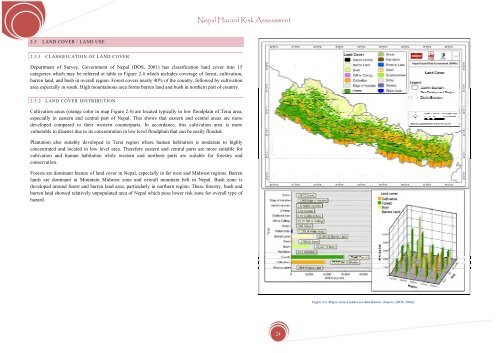
2.5 LAND COVER / LAND USE<br />
2.5.1 CLASSIFICATION OF LAND COVER<br />
Department of Survey, Government of <strong>Nepal</strong> (DOS, 2001) has classification land cover into 15<br />
categories which may be referred at table in Figure 2.4 which includes coverage of <strong>for</strong>est, cultivation,<br />
barren land, and bush in overall region. Forest covers nearly 40% of the country, followed by cultivation<br />
area especially in south. High mountainous area <strong>for</strong>ms barren land and bush in northern part of country.<br />
2.5.2 LAND COVER DISTRIBUTION<br />
Cultivation areas (orange color in map Figure 2.4) are located typically in low floodplain of Terai area,<br />
especially in eastern and central part of <strong>Nepal</strong>. This shows that eastern and central areas are more<br />
developed compared to their western counterparts. In accordance, this cultivation area is more<br />
vulnerable to disaster due to its concentration in low level floodplain that can be easily flooded.<br />
Plantation also suitably developed in Terai region where human habitation is moderate to highly<br />
concentrated and located in low level area. There<strong>for</strong>e eastern and central parts are more suitable <strong>for</strong><br />
cultivation and human habitation while western and northern parts are suitable <strong>for</strong> <strong>for</strong>estry and<br />
conservation.<br />
Forests are dominant feature of land cover in <strong>Nepal</strong>, especially in far west and Midwest regions. Barren<br />
lands are dominant in Mountain Midwest zone and overall mountain belt in <strong>Nepal</strong>. Bush zone is<br />
developed around <strong>for</strong>est and barren land area, particularly in northern region. These <strong>for</strong>estry, bush and<br />
barren land showed relatively unpopulated area of <strong>Nepal</strong> which pose lower risk zone <strong>for</strong> overall type of<br />
hazard.<br />
Figure 2.4. Major sectors landcover distribution. (Source: (DOS, 2001)).<br />
24


