

Nepal Hazard Risk Assessment - Asia-Pacific Gateway for Disaster ...
Nepal Hazard Risk Assessment - Asia-Pacific Gateway for Disaster ...
Nepal Hazard Risk Assessment - Asia-Pacific Gateway for Disaster ...

Create successful ePaper yourself
Turn your PDF publications into a flip-book with our unique Google optimized e-Paper software.
<strong>Nepal</strong> <strong>Hazard</strong> <strong>Risk</strong> <strong>Assessment</strong><br />
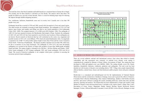
The trend line shows that flood, landslide and health hazards are consistent threat to human life in <strong>Nepal</strong>.<br />
The casualty rate <strong>for</strong> these hazards is consistent over the decade. The analysis shows that about 750<br />
people are killed every year due to these hazards. There is a need <strong>for</strong> initiating major steps <strong>for</strong> reducing<br />
the impacts through suitable mitigating measures.<br />
Fire, windstorms, hailstorm, thunderbolts come next in severity level. Casualty rate is less than 100<br />
people every year.<br />
Earthquake hazard has occurred in 1934 and 1988, caused wide devastation in Terai and central region.<br />
The small swarms are constantly occurring in Indo-<strong>Nepal</strong> boundaries. The earthquake of 1255 A.D. had<br />
destroy many houses and temples and killing one third to one fourth population of the Kathmandu<br />
Valley (NSC, 2009). The assigned intensity is X in MM scale (GR Chitrakar, 1986). The earthquake of<br />
1408 A.D. has been reported to destroy the Machhendra Nath temple of Patan. Similarly the earthquake<br />
of 1681 A.D. and 1810 A.D. have been reported to occur but the exact locations of these earthquakes are<br />
not known. Recent research on historical data has well constrained on the source size, magnitude and<br />
possible location of 1833 A.D. event (Bilham, 1995) which devastated Kathmandu valley. Its magnitude<br />
is reported to be of Mb=7.8 with possible rupture length of more than 70 km and the event is located at<br />
50 km North - North East of Kathmandu. The human casualties reported were less than 500, which may<br />
be due to occurrence of two large <strong>for</strong>eshocks. The earthquake of 1934 A.D is the most devastating<br />
earthquake ever occurred in the territory of <strong>Nepal</strong> with casualties of more than 16000 people including<br />
<strong>Nepal</strong> and India. The rupture length is estimated to be 200 Km ± 100 Km (Molnar and Pandey, 1994).<br />
Great Assam earthquake of 1897, Kangra earthquake 1905, and Assam earthquake 1950 were felt in<br />
<strong>Nepal</strong>. The record of historical earthquake is not complete which poses a problem in assessing the<br />
recurrence period of great earthquakes.<br />
Loss of Life<br />
10000<br />
1000<br />
100<br />
10<br />
Figure 2.1. Trend line showing annual occurrence of various disasters in <strong>Nepal</strong> (Based on <strong>Disaster</strong> Catalog developed by Ministry of Home Affairs,<br />
GON)<br />
2.3 SOURCE OF PROJECT RELATED DATA<br />
Chronology of <strong>Disaster</strong> Events In <strong>Nepal</strong> (1983-2003)<br />
Trendline <strong>for</strong> Annual Occurance<br />
Flood & Landslides Fire Epidemics windstorms/hailstorms/thunderbolts Earthquake Avalanches stampede<br />
Fire<br />
Earthquake<br />
Stampede<br />
Windstorms/ Hailstorms/ Thunderbolts<br />
Avalanches<br />
Floods & Landslides<br />
Epidemics<br />
1<br />
1982 1983 1984 1985 1986 1987 1988 1989 1990 1991 1992 1993 1994 1995 1996 1997 1998 1999 2000 2001 2002 2003 2004<br />
Year<br />
There are several authentic national and international sources, from where data related to hazard,<br />
vulnerability and risk assessment were extracted. At national level, disaster event catalog is<br />
comprehensively compiled by Ministry of Home Affairs, Government of <strong>Nepal</strong>. The catalog has been<br />
developed in 2000 and updated every year (MOHA, 2004). The catalog broadly covers fire, floods,<br />
landslides, thunderbolt, hailstorm, windstorm, epidemics and earthquakes. The each event has been<br />
detailed out with location of disaster event including district, VDC/ Village, date, people (injured/dead),<br />
affected families, animal losses, houses and shed destroyed, public property losses and gross estimated<br />
losses.<br />
DesInventar is a conceptual and methodological tool <strong>for</strong> the implementation of National <strong>Disaster</strong><br />
Observatories and the construction of database of damage, losses and in general the effects of disasters.<br />
It includes Data Collection Methodology, Data Analysis Methodology, database with flexible structure<br />
and Free, open-source software to manage the system, including multi-user, remote data entry and data<br />
querying, reporting and analysis. The DesInventar has been implemented in <strong>Nepal</strong> and created a huge<br />
database of disaster events and associated losses. It includes event, region, district, village, Date, Cause,<br />
Description of Cause, Source, Magnitude, Deaths, Injured, Missing, Houses Destroyed, Houses<br />
Damaged, Victims, Affected Relocated, Evacuated, Losses ($USD), Losses ($Local), Damages at crops<br />
21


