

Nepal Hazard Risk Assessment - Asia-Pacific Gateway for Disaster ...
Nepal Hazard Risk Assessment - Asia-Pacific Gateway for Disaster ...
Nepal Hazard Risk Assessment - Asia-Pacific Gateway for Disaster ...

You also want an ePaper? Increase the reach of your titles
YUMPU automatically turns print PDFs into web optimized ePapers that Google loves.
<strong>Nepal</strong> <strong>Hazard</strong> <strong>Risk</strong> <strong>Assessment</strong><br />
2.12 TRANSPORTATION SECTOR<br />
2.12.1 TYPE OF TRANSPORTATION<br />
Several transportation infrastructures exist in <strong>Nepal</strong>. The most prevalent features are classified as cart<br />
track, and main trail (DOS, 2001). Road highway mostly developed in Terai area with low leveled<br />
terrain condition and reached more than 2,500 km in total length (Figure 2.17).<br />
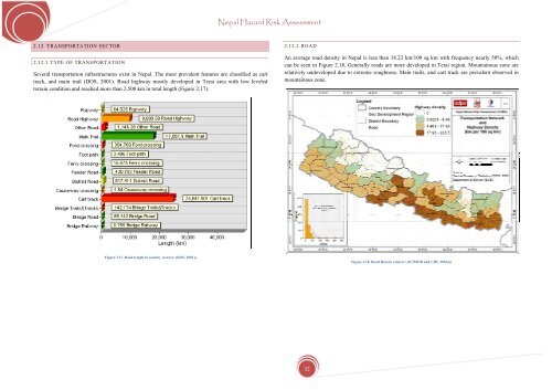
2.12.2 ROAD<br />
An average road density in <strong>Nepal</strong> is less than 18.22 km/100 sq km with frequency nearly 50%, which<br />
can be seen in Figure 2.18. Generally roads are more developed in Terai region. Mountainous zone are<br />
relatively undeveloped due to extreme roughness. Main trails, and cart track are prevalent observed in<br />
mountainous zone.<br />
Figure 2.17. Road length in country (source: (DOS, 2001))<br />
Figure 2.18. Road Density (source: (ICIMOD and CBS, 2003a))<br />
32


