<strong>Nepal</strong> <strong>Hazard</strong> <strong>Risk</strong> <strong>Assessment</strong> 3.7 APPROACH FOR MULTI-HAZARD ASSESSMENT The study reveals that <strong>Nepal</strong> is prone to various kinds of hazards. There is a dire need to diagnose all possible hazards in the country and evolve strategy to mitigate the negative impacts of prevailing hazards. The idea behind the multi-hazard assessment (Multi-HA) is to compare the severity of various hydro-meteorological, geological and health hazards, understand the distribution of various hazards in the country, identify multiple hazard districts and region, their causative factors and identify the regions and districts <strong>for</strong> intensifying mitigation intervention. 3.7.1 APPLICATION OF MULTI-HAZARD ASSESSMENT (MULTI-HA) • Multi-HA facilitates nodal disaster management agency (MOHA), Government and Non-government agencies to launch mitigation projects integrating all hazard approach. This will help the implementing agency to optimize project resources and reduce the project implementation cost by integrating all hazard approach. • Multi-HA provides necessary background <strong>for</strong> policy development, awareness and knowledge about disaster risk reduction. • Multi-HA provides better understanding about correlation and linkage between various hazards and causative factors. • The assessment facilitates better cooperation between various agencies working in the area of hazard mitigation and management. For example, MOHA is overall managing the disasters, however, Department of Mines and Geology, DWIDP, DMH, Department of Road and many more agencies are working in geological and hydro-meteorological hazards. The Multi-HA provides conducive plat<strong>for</strong>m <strong>for</strong> communication, cooperation and collaboration towards creating disaster resilient society. 3.7.2 METHODOLOGY FOR MULTI HAZARD ASSESSMENT The details of earthquake, landslide, floods, drought and health hazard assessment have been discussed in earlier sections. The previous sections have identified districts and regions prone to various types of hazards. Based on earlier assessment, the Multi-HA criteria have been developed. These are as below: • Two scenarios are considered. Scenario-One includes earthquake of 500 year return period, Earthquake induced landslide, Rainfall induced landslides, Floods of 10 years return period, Drought in winter and Health hazards susceptibility. The Scenario-Two includes earthquake of 250 years return period, Rainfall induced landslides, Floods of 10 years return period, Drought in winter and Health hazards susceptibility. • Two earthquake scenarios are considered <strong>for</strong> multi hazard assessment ie., earthquake of return period 500 years and 250 years. For Multi-HA purpose, only high and very high earthquake hazard prone areas have been considered. The GIS tools are used to tabulate area coverage under each class of severity. The threshold value <strong>for</strong> identification of district <strong>for</strong> earthquake hazard is 33% of area falling under high and very high earthquake severity. • Earthquake induced landslides hazard assessment is carried out based on 500 years return period. The medium and high landslide susceptible area of each district has been calculated. If the district’s area more than 15% falls under medium and high landslide hazard, they district is considered as earthquake induced landslide prone district. • Precipitation induced landslide has been carried out, which has been classified into negligible, low, medium and high susceptible zones. Similar to earthquake induced landslide, the districts have been identified as landslide prone which is having more than 15 % of area falling under medium to high susceptible zones. • Flood hazard assessment has been carried out <strong>for</strong> seven rivers. The flood hazard assessment has been carried out <strong>for</strong> 10 years, 25 years, 50 years, 100 Years and 500 years. The flood depth and inundation area has been calculated <strong>for</strong> each affected district. These all districts have been considered <strong>for</strong> Multi- HA criteria. • Drought hazard assessment considers districts having critical drought during winter season. • Disease and outbreak susceptible districts have been identified. There are 12 disease and outbreak cases are considered under health hazard. The district having three of more types of health hazards are considered <strong>for</strong> Multi-HA. Based on above stated criteria two scenarios are created. The results are presented in tabular <strong>for</strong>ms <strong>for</strong> reference. 3.7.3 ANALYSIS OF MULTI-HA • The scenario one considers six types of hazards. The analysis shows that more than 55 districts are prone to more than three hazards. The breakdown is given below in Table 3.10. Table 3.10 Districts prone to multiple hazards under scenario one S. no Number of Districts Number of <strong>Hazard</strong>s 1 Jhapa, Pythan, Sankhuasabha, Bhojpur, Khotang, Okhaldhunga, Udaypur, Sarlahi, Ramechhap, Dolakha, Sindhupalchowk, Kabhrepalanchok, Bhaktapur, Kathmandu, Nuwakot, Rasuwa, Chitawan, Gorkha, Lamjung, Tanahu, Parbat, Baglung, Myagdi, Nawalparasi, Arghakhanchi, Gulmi, Banke, Dolpa, Jumla, Mugu, Humla, Bajhang, Bajura, Doti, Kailali, Dadeldhura, Baitadi and Darchula. 2 Ilam, Lalitpur, Dhading, Kaski, Syangja, Mustang, Rukum,Makawanpur, Dang, Jajarkot, Dailekh, Kalikot and Accham Three types of Geological, Hydro-meteorological hazards Four types of Geological, Hydro-meteorological hazards 3 Sindhuli, Salyan and Rolpa Five types of Geological, Hydro-meteorological hazards 86
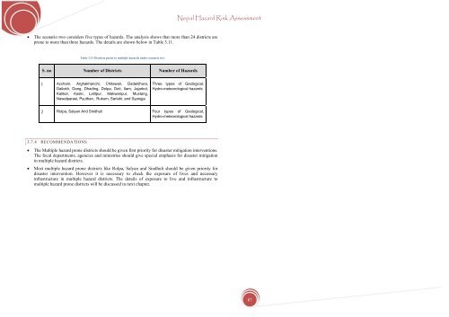
<strong>Nepal</strong> <strong>Hazard</strong> <strong>Risk</strong> <strong>Assessment</strong> • The scenario two considers five types of hazards. The analysis shows that more than 24 districts are prone to more than three hazards. The details are shown below in Table 3.11. Table 3.11 Districts prone to multiple hazards under scenario two S. no Number of Districts Number of <strong>Hazard</strong>s 1 Accham, Arghakhanchi, Chitawan, Dadeldhura, Dailekh, Dang, Dhading, Dolpa, Doti, Ilam, Jajarkot, Kalikot, Kaski, Lalitpur, Makwanpur, Mustang, Nawalparasi, Pyuthan, Rukum, Sarlahi, and Syangja Three types of Geological, Hydro-meteorological hazards 2 Rolpa, Salyan And Sindhuli Four types of Geological, Hydro-meteorological hazards 3.7.4 RECOMMENDATIONS • The Multiple hazard prone districts should be given first priority <strong>for</strong> disaster mitigation interventions. The focal departments, agencies and ministries should give special emphasis <strong>for</strong> disaster mitigation in multiple hazard districts. • Most multiple hazard prone districts like Rolpa, Salyan and Sindhuli should be given priority <strong>for</strong> disaster intervention. However it is necessary to check the exposure of lives and necessary infrastructure in multiple hazard districts. The details of exposure to live and infrastructure to multiple hazard prone districts will be discussed in next chapter. 87