

Nepal Hazard Risk Assessment - Asia-Pacific Gateway for Disaster ...
Nepal Hazard Risk Assessment - Asia-Pacific Gateway for Disaster ...
Nepal Hazard Risk Assessment - Asia-Pacific Gateway for Disaster ...

You also want an ePaper? Increase the reach of your titles
YUMPU automatically turns print PDFs into web optimized ePapers that Google loves.
<strong>Nepal</strong> <strong>Hazard</strong> <strong>Risk</strong> <strong>Assessment</strong><br />
3.3 LANDSLIDE HAZARD ASSESSMENT<br />
Landslide hazard is frequent phenomenon is <strong>Nepal</strong> due to several reasons including tectonic activities,<br />
uncontrolled and unsafe development, heavy precipitation and environmental degradation. However it is<br />
observed that rainfall induced landslides is most prevalent in the hills and mountainous districts. In view<br />
of rapid development in hills and mountains in the country, it has become imperative to review, identify<br />
and analyze landslide prone areas and their causative factors. The present landslide hazard assessment<br />
carries out the hazard zonation of the country based on two triggering factors like earthquake and heavy<br />
precipitation.<br />
3.3.1 MAP CONTENT<br />
Landslide hazard maps show two classes of landslide zoning caused by earthquake events and heavy<br />
rainfall. The maps further show landslide hazard severity distribution in all districts triggered by above<br />
stated factors.<br />
3.3.2 APPLICATION OF MAPS IN DISASTER RISK MANAGEMENT<br />
• Two types of maps show the severity of landslide caused by rainfall and seismic events. The<br />
maps will help the planning and development agencies <strong>for</strong> physical and social development in<br />
hazard prone areas.<br />
• The maps will be especially helpful to Ministry of Physical Planning and Works, Ministry of<br />
In<strong>for</strong>mation and Communication, Ministry of Irrigation, Department of Electricity Development,<br />
Department of Road <strong>for</strong> sectoral development in landslide prone districts and region.<br />
• The study reveals that road sector is most prone to landslides during monsoon season. The<br />
Department of Road has initiated several structural mitigation projects at local level. The maps<br />
will help in identifying the sites <strong>for</strong> structural and non structural mitigation projects. The maps<br />
will help in prioritizing the site specific studies and mitigation interventions.<br />
• DWIDP closely monitors water induced disaster activities. The maps will help the department to<br />
focus on landslide disaster prone areas and seek cooperation with various other response agencies<br />
and departments <strong>for</strong> better disaster preparedness.<br />
• Precipitation data from Global Precipitation Climatology Centre (GPCC) that can be assessed in<br />
http://gpcc.dwd.de<br />
• Land cover database from European Space Agency (ESA) that can be assessed in<br />
http://www.esa.int/esaEO/SEMGSY2IU7E_index_0.html<br />
• Seismic Trigger Factor from PGA by NGI (NGI, 2004)<br />
The details of data may be referred at reference section of the report.<br />
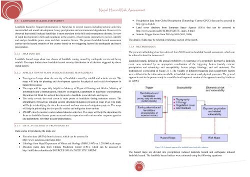
3.3.4 METHODOLOGY<br />
The present methodology has been derived from NGI based on landslide hazard assessment, which can<br />
be referred in detail in Annexure-2.<br />
Landslide hazard, defined as the annual probability of occurrence of a potentially destructive landslide<br />
event, was estimated by an appropriate combination of the triggering factors (mainly extreme<br />
precipitation and seismicity) and susceptibility factors (slope, lithology, and soil moisture). The<br />
methodology is presented in Figure 3.11. The weights of different triggering and susceptibility factors<br />
were calibrated to the in<strong>for</strong>mation available in landslide inventories and physical processes. The general<br />
approach used in the present study is a modified and improved version of the approach used by Nadim et<br />
al. (2006).<br />
3.3.3 DATA AVAILABILITY FROM SOURCES<br />
Data source <strong>for</strong> producing the maps are:<br />
• Elevation data (SRTM) from Isciences, which can be assessed in<br />
http://www.isciences.com/index.html<br />
• Lithology from <strong>Nepal</strong> Department of Mines and Geology (DMG, 1987) on 1:250.000 scale maps<br />
• Moisture index data from Climate Prediction Center (CPC), which can be assessed in<br />
http://iridl.ldeo.columbia.edu/SOURCES/.NOAA/.NCEP/.CPC/.GMSM/<br />
Figure 3.11. Schematic approach <strong>for</strong> landslide hazard and risk evaluation.<br />
The hazard maps are divided into precipitation induced landslide hazard and earthquake induced<br />
landslide hazard. The landslide hazard indices were estimated using the following equations:<br />
50


