

Nepal Hazard Risk Assessment - Asia-Pacific Gateway for Disaster ...
Nepal Hazard Risk Assessment - Asia-Pacific Gateway for Disaster ...
Nepal Hazard Risk Assessment - Asia-Pacific Gateway for Disaster ...

You also want an ePaper? Increase the reach of your titles
YUMPU automatically turns print PDFs into web optimized ePapers that Google loves.
<strong>Nepal</strong> <strong>Hazard</strong> <strong>Risk</strong> <strong>Assessment</strong><br />
2.10 IRRIGATION INFRASTRUCTURE SECTOR<br />
Department of Irrigation (CERD, 2007) has classified types of irrigation into three categories, i.e.<br />
Surface irrigation, Ground water and non conventional irrigation. Application of type of irrigation<br />
depends upon geographical location.<br />
2.10.1 SURFACE IRRIGATION<br />
The surface irrigation broadly covers Department of Irrigation (DoI) and Farmer Management Irrigation<br />
System (FMIS). Most of the farwestern and mid-wastern regions are covered under FMIS. Central and<br />
eastern part of <strong>Nepal</strong> is mostly covered by FMIS. However in Terai region, stretching from west to east,<br />
both type of irrigation system exists. Figure 2.11, the map shows the proportion of surface irrigation area<br />
in pie chart. The background show total area of surface irrigation in each district.<br />
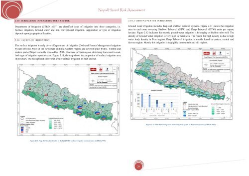
2.10.2 GROUND WATER IRRIGATION<br />
Ground water irrigation includes deep and shallow tubewell systems. Figure 2.11 shows the irrigation<br />
area in each zone covering Shallow Tubewell (STW) and Deep Tubewell (DTW) units per square<br />
hectare. Figure 2.12 indicates that mostly ground water irrigation is belonging to Shallow tube well. The<br />
density of Ground water irrigation is very high in Terai area. The reason <strong>for</strong> high density is due to high<br />
water body density in Terai region. Deep Tubewell irrigation is mostly found in eastern, central and<br />
farwest region. Mostly this irrigation is negligible in mountain and hill regions.<br />
Figure 2.12. Distribution of ground water irrigation system in the country (source: (CERD, 2007))<br />
Figure 2.11. Map showing distribution of DoI and FMIS surface irrigation system (source: (CERD, 2007))<br />
29


