

Nepal Hazard Risk Assessment - Asia-Pacific Gateway for Disaster ...
Nepal Hazard Risk Assessment - Asia-Pacific Gateway for Disaster ...
Nepal Hazard Risk Assessment - Asia-Pacific Gateway for Disaster ...

Create successful ePaper yourself
Turn your PDF publications into a flip-book with our unique Google optimized e-Paper software.
<strong>Nepal</strong> <strong>Hazard</strong> <strong>Risk</strong> <strong>Assessment</strong><br />
H r = (S r x Six S h x S v )xT p (1)<br />
H e = (Sr X Si X Sh X Sv) x T s (2)<br />
Where Hr and He are landslide hazard indices <strong>for</strong> rainfall and earthquake induced landslides respectively,<br />
Sr is the slope factor within a selected grid, Sl is lithological (or geological) conditions factor, S h<br />
describes the soil moisture condition, T p is the precipitation factor and T s describes the seismic<br />
conditions. The index Sv described the vegetation cover.<br />
3.3.5 HOW TO READ THE MAPS<br />
Both classes of landslide hazard maps contain 4 categorized zones as negligible, low, medium, and high.<br />
The legend shown in maps is indicating color and respective hazard zoning.<br />
Negligible –Very low probability of landsldies<br />
Low - Low probability of landsldies<br />
Medium – Medium probability of landsldies<br />
High –High probability of landsldies<br />
The Table 3.6 and Table 3.7 show percentage area distribution of landslide zone within each district.<br />
These maps are presented <strong>for</strong> country scale. Slightly more detail in<strong>for</strong>mation can be referred <strong>for</strong> district<br />
level, especially <strong>for</strong> the dominant landslides classes.<br />
3.3.6 ANALYSIS OF HAZARD ASSESSMENT<br />
Slope, lithology, soil moisture, and precipitation are controlling factors <strong>for</strong> landslide hazard, while<br />
earthquake and rainfall are triggering factors. Peak of monsoon usually correlate with high landslide<br />
events in <strong>Nepal</strong> due to high precipitation. Data on the importance of earthquake triggered vs<br />
precipitation triggered in terms of fatalities may not be easily available. It is known that in some cases, a<br />
significant share of the earthquake fatalities are killed by earthquake triggered landslides.<br />
High susceptibility zone of landslide due to earthquake hazard are distributed in centre (hill) zone of<br />
<strong>Nepal</strong>, which is largely dependent on PGA values. Medium severity zone situated surrounding high<br />
severity zone and cover smaller percentage of geographical area. Negligible and low zone areas are<br />
located in north and southern border of <strong>Nepal</strong>. Figure 3.14 provides insight of area covered under<br />
earthquake induced landslide in the country. As per the assessment, <strong>for</strong> 500 years return period induced<br />
landslides, two third of the areas of Myagdi, Ramechhap, Parbat, Jajarkot, Kalikot, Okhaldhunga,<br />
Rukum and Baglung will be in high landslide susceptible zone. Similarly more than one third of the<br />
Solukhumbu, Sankhuasabha, Dolakha, Khotang, Accham, Sindhupalchowk, Bhaktapur, Baitadi, Rolpa,<br />
Sindhuli, Lamjung, Dailekh, Syangja, Kabhrepalanchok, Bajura, Nuwakot, Dhading, Tanahu, Kaski,<br />
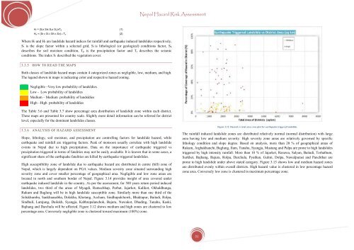
Bajhang and Darchula will be affected. Figure 3.12 shows medium and high zones are clustered to low<br />
percentage area. Conversely negligible zone is clustered toward maximum (100%) zone.<br />
Figure 3.12. <strong>Hazard</strong> vs total area cross plot <strong>for</strong> earthquake triggered landslide.<br />
The rainfall induced landslide zones are distributed relatively normal (normal distribution) with large<br />
area having low and medium severity. High severity zone areas are relatively governed by specific<br />
lithology condition and slope degree. Based on analysis, more than 20 % of geographical areas of<br />
Rukum, Arghakhanchi, Baglung, Ilam, Tanahu, Syangja, Mustang and Palpa are prone to high landslides<br />
triggered by high intensity rainfall. More than 10 % of Jajarkot, Rasuwa, Salyan, Baitadi, Terhathum,<br />
Surkhet, Bajhang, Bajura, Rolpa, Darchula, Pyuthan, Gulmi, Dolpa, Nawalparasi and Panchthar are<br />
prone to high landslide under above stated category. Figure 3.13 shows low and medium hazard zones<br />
are distributed evenly within overall districts. High hazard value is clustered in low percentage hazard<br />
zone area. Conversely low zone is clustered in maximum percentage zone.<br />
51


