

Nepal Hazard Risk Assessment - Asia-Pacific Gateway for Disaster ...
Nepal Hazard Risk Assessment - Asia-Pacific Gateway for Disaster ...
Nepal Hazard Risk Assessment - Asia-Pacific Gateway for Disaster ...

Create successful ePaper yourself
Turn your PDF publications into a flip-book with our unique Google optimized e-Paper software.
<strong>Nepal</strong> <strong>Hazard</strong> <strong>Risk</strong> <strong>Assessment</strong><br />
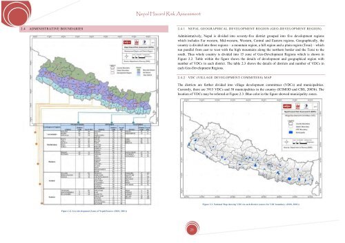
2.4 ADMINISTRATIVE BOUNDARIES<br />
2.4.1 NEPAL GEOGRAPHICAL DEVELOPMENT REGION (GEO-DEVELOPMENT REGION)<br />
Administratively, <strong>Nepal</strong> is divided into seventy-five district grouped into five development regions<br />
which includes Far western, Mid-western, Western, Central and Eastern regions. Geographically, the<br />
country is divided into three regions – a mountain region, a hill region and a plain region (Terai) – which<br />
run parallel from east to west with the high mountains along the northern border and the Terai to the<br />
south. Thus whole country is divided into 15 zone of Geo-Development Regions which is shown in<br />
Figure 2.2. Table within the figure shows the details of development and geographical region with<br />
number of VDCs in each district. The table 2.3 shows the details of districts and number of VDCs in<br />
each Geo-Development Regions.<br />
2.4.2 VDC (VILLAGE DEVELOPMENT COMMITEES) MAP<br />
The districts are further divided into village development committees (VDCs) and municipalities.<br />
Currently, there are 3915 VDCs and 58 municipalities in the country (ICIMOD and CBS, 2003b). The<br />
location of VDCs may be referred at Figure 2.3. Blue color in the figure showed municipality zones.<br />
Figure 2.3. National Map showing VDCs in each district (source <strong>for</strong> VDC boundary: (DOS, 2001))<br />
Figure 2.2. Geo-development Zones of <strong>Nepal</strong>(Source: (DOS, 2001))<br />
23


