

Nepal Hazard Risk Assessment - Asia-Pacific Gateway for Disaster ...
Nepal Hazard Risk Assessment - Asia-Pacific Gateway for Disaster ...
Nepal Hazard Risk Assessment - Asia-Pacific Gateway for Disaster ...

You also want an ePaper? Increase the reach of your titles
YUMPU automatically turns print PDFs into web optimized ePapers that Google loves.
<strong>Nepal</strong> <strong>Hazard</strong> <strong>Risk</strong> <strong>Assessment</strong><br />
in hectare, Lost Catle and Damages of roads (Mts). The data is mostly collected from newspapers<br />
namely Gorakhapatra or other reputed newspapers. The DesInventar covers largely earthquake, floods,<br />
landslides, drought, and epidemics events.<br />
Apart from these sources, data is also available with several national reputed institutions, departments<br />
and ministries. The brief in<strong>for</strong>mation about the data availability may be referred at Table 2.2.<br />
At international level, Centre <strong>for</strong> Research on the Epidemiology of <strong>Disaster</strong>s (CRED, 2009) has<br />
developed comprehensive database <strong>for</strong> disaster events and associated losses. EM-DAT contains essential<br />
core data on the occurrence and effects of over 16,000 mass disasters in the world from 1900 to present.<br />
The database is compiled from various sources, including UN agencies, non-governmental<br />
organizations, insurance companies, research institutes and press agencies. EM-DAT distinguishes two<br />
generic categories <strong>for</strong> disasters (natural and technological), the natural disaster category being divided<br />
into 5 sub-groups, which in turn cover 12 disaster types and more than 30 sub-types. There are several<br />
international organizations Viz., United States Geological Survey (USGS), ANSS, Berkeley University<br />
are maintaining the earthquake catalog globally.<br />
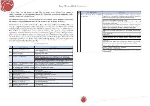
Table 2.2. Source of in<strong>for</strong>mation.<br />
No Name of Organization Type of Data<br />
1 Department of Hydrology & Meteorology Climate and meteorological data, rainfall in<strong>for</strong>mation, spatial temperature distribution,Early<br />
warning communication systems,<br />
2 Ministry of Forest and Soil Conservation Forest cover, Soil maps<br />
3 Ministry of Home Affairs<br />
<strong>Disaster</strong> data on various hazard,<br />
economic losses<br />
4 Department of Geology and Mines<br />
Geological map of <strong>Nepal</strong> ( scale 1:50,000), Geographical Map, Seismo-tectonic map<br />
Active fault and lineament mapping, Cross sectional profile of <strong>Nepal</strong> , PGA distribution<br />
Seismic zoning, Soil profile of <strong>Nepal</strong>, Earthquake catalogue(Micro tremor / Major Events<br />
Historical events and associated intensity mapping , Seismograph network,, Study on Seismic<br />
hazards and collateral hazards, Bed rock motion studies <strong>for</strong> <strong>Nepal</strong>, JICA report,<br />
5 Department of Water induced <strong>Disaster</strong> Prevention Details of hydrological parameters, rainfall details, Floods details of main catchments<br />
6 Department of Agriculture Crop typology, drought events, crops affected by floods and droughts<br />
7 United Nations Development program (UNDP) Initiatives <strong>for</strong> <strong>Disaster</strong> risk reduction<br />
8 The International Centre <strong>for</strong> Integrated Mountain Flood, GLOF and landslide studies and maps<br />
Development ICIMOD<br />
9 Central Bureau of Statistics Census 2001 dataset<br />
10 Ministry of Culture Tourism & Civil Aviation Details of aviation sector, Tourism assets<br />
11 Ministry of Education & Sports Education units and associated database<br />
12 Ministry of Finance Economic parameters <strong>for</strong> development and disasters<br />
13 Ministry of Health and Population Epidemic data , Health Infrastructure<br />
14 Ministry of Agriculture and Cooperative Crop Pattern, production yield,<br />
15 Ministry of Industry Commerce & Supplies Industrial Infrastructure, products, industrial locations<br />
16 Ministry of In<strong>for</strong>mation & Communications Telecommunication, television, radio Infrastructure<br />
17 Ministry of Local Development Local government Infrastructure<br />
18 Ministry of Physical Planning & Works Community , government built infrastructure , roads database<br />
19 Department of Electricity Development Power infrastructure<br />
20 Ministry of Irrigation Irrigation Infrastructure database<br />
No Name of Organization Type of Data<br />
21 The Survey Department / Ministry of Land Re<strong>for</strong>m<br />
and Management<br />
Survey Department has a broad multi-disciplinary resource base and produces a wide range<br />
of ground survey, aerial photography, photogrammetry, geo-in<strong>for</strong>mation and cadastral map<br />
products and services in order to support multi-sectoral development activities.<br />
At 1:100,000 Scale, the attributes and features are as below:<br />
Details of Layers : Admin Boundary /Transport /Building /Hydrography /Contour /Designated<br />
area /Untility lines, Attributes details :<br />
Functional use: but terminal/ commercial/ customs/ factory / fire stations/ health posts/<br />
hospitals/ industrial/ petrol pumps/ post office/ power stations/ railway st/ residence/<br />
ropeways/ schools/ telephone office/ trans<strong>for</strong>mer st/ monuments/ chimney/ mining<br />
Religious building : Temple/ stupa/ mane/ church/ moque/ cemetery/ crematorium<br />
Structure type: Cave/ chimney/ gate/ mining site/ open shed/ revetment/ ruins/ view towers/<br />
wall<br />
Contour : contour value<br />
Spot elevation<br />
Administration area: country/ region/ zone/ district / municipality / VDC<br />
Designated area: national parks/ wild life reserve/ sanctuary / conservation area/ reserved<br />
<strong>for</strong>est<br />
Feature Class<br />
Transportation : Roads : Highway/ feeder road/ district road/ other roads / Trails and tracks :<br />
Cart track / Railways /Ropeways/Bridge /Other crossings/Tunnel/Airport / Buildings<br />
Built up area/Buildings/Religious /Other structures<br />
Landcover : Cultivation /Vegetation/Others /Hydrography<br />
River/ streams/Glaciers /Canals/Ponds / lakes<br />
Utility : Electricity /Telephone/Telegraph/Transmission/Tower /Pipe Line/Water<br />
Line/Sewerage Line<br />
22


