Nepal Hazard Risk Assessment - Asia-Pacific Gateway for Disaster ...
Nepal Hazard Risk Assessment - Asia-Pacific Gateway for Disaster ...
Nepal Hazard Risk Assessment - Asia-Pacific Gateway for Disaster ...
You also want an ePaper? Increase the reach of your titles
YUMPU automatically turns print PDFs into web optimized ePapers that Google loves.
<strong>Nepal</strong> <strong>Hazard</strong> <strong>Risk</strong> <strong>Assessment</strong><br />
3.4.7 RECOMMENDATIONS<br />
• The profile of flood hazard maps <strong>for</strong> Babai, Bagmati, Rapti, Kamala, Kankai, Tinau and Narayani<br />
rivers are presented in Figure 3.27 to Figure 3.33 respectively.<br />
• The flood hazard maps have been developed at national level scale using secondary data. The data<br />
used <strong>for</strong> the modeling is primarily from DMH, DWIDP and DOS. The current flood hazard maps<br />
show a broader picture of area under flood inundation. However, it is imperative to carry out site<br />
specific flood hazard mapping <strong>for</strong> local level planning.<br />
• The hydrological and hydro-meteorological data <strong>for</strong> flood hazard assessment are scarce and requires<br />
ef<strong>for</strong>ts from departments to collect and compile <strong>for</strong> precise flood hazard mapping.<br />
• The current flood hazard maps have been developed <strong>for</strong> most important river basins that are<br />
frequently flooded and affected life and properties. Though there are many rivers, which do not<br />
expose life and properties much, it was felt that carrying out flood hazard maps <strong>for</strong> such basins are<br />
also important.<br />
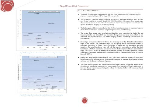
Figure 3.25.Percentage of flood hazard area with respect to district area at 100 years return period<br />
• Since <strong>Nepal</strong> is frequently affected by floods, it is necessary to develop detailed flood inundation<br />
maps <strong>for</strong> the country. The inundation maps will help policy makers and decision makers to<br />
understand the severity of floods. They will also help in damage and loss assessment, and relief<br />
operations. The actual inundation maps will help the scientific community to validate the flood<br />
hazard maps. UNOSAT supports the activities involved in the development of hazard and inundation<br />
maps. The UNOSAT is the UN Institute <strong>for</strong> Training and Research (UNITAR) Operational Satellite<br />
Applications Programme, implemented in co-operation with the European Organization <strong>for</strong> Nuclear<br />
Research (CERN).<br />
• DWIDP and DMH along with other agencies like ICIMOD have carried out several pilot based flood<br />
hazard mapping <strong>for</strong> important rivers. An approach is required to integrate these maps at suitable<br />
scale and used <strong>for</strong> disaster resilient development.<br />
• The floods hazard map show that most developed districts like Lalitpur, Kathmandu, Bhaktapur and<br />
other districts contributing to economy are coming under flood inundation. There is a dire need to<br />
introduce disaster preparedness and mitigation policies <strong>for</strong> reducing the flood risk in most developed<br />
but flood affected areas.<br />
Figure 3.26.Percentage of flood hazard area with respect to district area at 500 years return period<br />
59


