

Nepal Hazard Risk Assessment - Asia-Pacific Gateway for Disaster ...
Nepal Hazard Risk Assessment - Asia-Pacific Gateway for Disaster ...
Nepal Hazard Risk Assessment - Asia-Pacific Gateway for Disaster ...

You also want an ePaper? Increase the reach of your titles
YUMPU automatically turns print PDFs into web optimized ePapers that Google loves.
<strong>Nepal</strong> <strong>Hazard</strong> <strong>Risk</strong> <strong>Assessment</strong><br />
More than two third of the geographical area of 19 districts including Pyuthan,Sarlahi, Panchthar,<br />
Manang, Dadeldhura, Makawanpur, Rasuwa, Bajura, Solukhumbu, Jumla, Udayapur, Taplejung, Rolpa,<br />
Terhathum, Bajhang, Dolakha, Sindhupalchok, Doti and Darchula are falling under very high risk zone.<br />
The distribution of medium, high and very high earthquake risk zone area wrt five development regions<br />
and three belts are shown in inset graph within Figure 3.7.<br />
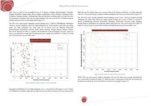
The 250 Years return period earthquake hazard mapping have 2 districts (Okhaldhunga, Bhaktapur)<br />
which are located completely under very high earthquake risk. Twelve districts with large area falling<br />
under very high earthquake risk (more than 2/3 of district area) are Dhanusa, Ramechap,<br />
Kabrepalanchok, Kathmandu, Nuwakot, Kaski, Parbat, Baglung, Myagdi, Rukum, Jajarkot, Kalikot.<br />
This can be observed in Table 3.3, together with distribution in lower earthquake risk zone. Figure 3.4<br />
shows even distribution of high and very high hazard class, ranged from 1000 km 2 to 2700 km 2 on total<br />
area. Several districts are near 100% zone.<br />
High risk zone has slightly larger area coverage, followed by medium and then by very high earthquake<br />
risk zone. Terai area has large coverage of medium earthquake risk zone as seen from inset in Figure 3.8.<br />
The 100 Years return period earthquake hazard mapping covers 2 zone, which are medium and high<br />
earthquake risk. Thirty four districts are largely located in high zone as seen in Table 3.4. Around 11<br />
districts (Okhaldhunga, Dhanusa, Ramechhap, Bhaktapur, Kathmandu, Nuwakot, Kaski, Baglung,<br />
Myagdi, Rukum, and Kalikot) are completely falling under high zone. This can be observed in Table 3.4.<br />
Figure 3.5 shows cluster of points (both of medium and high hazards zones) toward 100% zone.<br />
Figure 3.5. <strong>Hazard</strong> vs total area cross plot <strong>for</strong> 100 year return period.<br />
Figure 3.4. <strong>Hazard</strong> vs total area cross plot <strong>for</strong> 250 year return period.<br />
Within 100 year return period, medium earthquake risk zone has larger area coverage than high risk<br />
zone, which may be referred in Figure 3.9. High risk zone is concentrated in Hill belt, and followed by<br />
Mountain area and last by Terai area which are referred in inset graph in Figure 3.9.<br />
Geographical distribution of very high earthquake zone is concentrated in hill region as seen in Figure<br />
3.8. Distribution of medium, high and very high risk zone are relative uni<strong>for</strong>m in 250 year return period.<br />
43


