Water Users Association and Irrigation Management - Institute for ...
Water Users Association and Irrigation Management - Institute for ...
Water Users Association and Irrigation Management - Institute for ...

You also want an ePaper? Increase the reach of your titles
YUMPU automatically turns print PDFs into web optimized ePapers that Google loves.
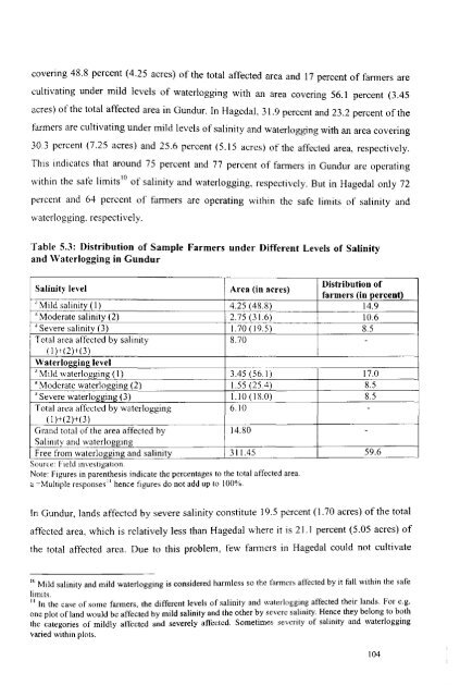
covering 48.8 percent (4.25 acres) of the total affected area <strong>and</strong> 17 percent of farmers are<br />
cultivating under mild levels of waterlogging with an area covering 56.1 percent (3.45<br />
acres) of the total affected area in Gundur. In Hagedal. 31.9 perccnt <strong>and</strong> 23.2 percent of the<br />
farmers are cultivating under mild levels of salinity <strong>and</strong> waterlogging with an area covering<br />
30.3 percent (7.25 acres) <strong>and</strong> 25.6 percent (5.15 acres) of the affected area, respectively.<br />
This indicates that around 75 percent <strong>and</strong> 77 percent of farmers in Gundur are operating<br />
within the safe limits lO of salinity <strong>and</strong> waterlogging, respectively. But in Hagedal only 72<br />
percent <strong>and</strong> 64 percent of farmers are operating within the safe limits of salinity <strong>and</strong><br />
waterlogging. respectively.<br />
Table 5.3: Distribution of Sample Farmers under Different Levels of Salinity<br />
<strong>and</strong> <strong>Water</strong>logging in Gundur<br />
Salinity level<br />
Area (in acres)<br />
Distribution of<br />
farmers (in percent)<br />
., Mild salinity (I) 4.25 (488) 14.9<br />
'Moderate salinity (2) 2.75 (31.6) 10.6<br />
'Severe salinity (3) 1.70 (19.5) 8.5<br />
Total area affected by salinity 8.70 -<br />
(I )+(2)+(3)<br />
<strong>Water</strong>logging level<br />
----- ---<br />
.. Mild waterlogging (I) 3.45 (56.1) 17.0<br />
'Moderate waterlogging (2) 1.55 (25.4) 8.5<br />
'Severe waterlogging (3) 1.10 (18.0) 8.5<br />
Total area affected by waterlogging 6.10 -<br />
(I )+(2)+(3)<br />
Gr<strong>and</strong> total of the area affected by 14.80 -<br />
Salinity <strong>and</strong> waterlogging<br />
Free from waterlogging <strong>and</strong> salinity 3 I 1.45 59.6<br />
.<br />
Source: held investIgatIOn.<br />
Note: Figures in parenthesis indicate the percentages to the total affected area.<br />
a ~Multiple responses" hence figures do not add up to 100%.<br />
In Gundur, l<strong>and</strong>s affected by severe salinity constitute 19.5 percent (1.70 acres) of the total<br />
affected area, which is relatively less than Hagedal where it is 21.1 percent (5.05 acres) of<br />
the total affected area. Due to this problem, few fanners in Hagedal could not cultivate<br />
10 Mild salinity <strong>and</strong> mild waterlogging is considered harmless so the farmers affected by it fall within the safe<br />
limits. d h . I d F<br />
"[ th ' f· me ~armers<br />
n e case a so<br />
the different levels of salinity <strong>and</strong> waterlogging affecte t elr an s. or e.g.<br />
Ii , .. H th bIt b h<br />
one plot of l<strong>and</strong> would be affected by mild salinity <strong>and</strong> the other by severe sahmty. ence ey e ong 0 at<br />
the categories of mildly affected <strong>and</strong> severely affected. Sometimes seventy of sahmty <strong>and</strong> waterloggmg<br />
varied within plots.<br />
104