- Page 1 and 2:
Water Users Association and Irrigat
- Page 3 and 4:
Phone: 91 080-23215468/5592/5519 FA
- Page 5 and 6:
grant was of great help in undertak
- Page 7 and 8:
LIST OF TABLES Page. No. 1.1: Outla
- Page 9 and 10:
8.3: Estimated Production Functions
- Page 11 and 12:
Chapter 1 Introduction The natural
- Page 13 and 14:
partition, 8.8 million hectares of
- Page 15 and 16:
levels. This is more so with major
- Page 17 and 18:
"twin problems" (Details of general
- Page 19 and 20:
~~~,~~ Figure 1.1 gives the data fr
- Page 21 and 22:
much lower at 1.6 million hectares
- Page 23 and 24:
Table 1.3: Incidence of Waterloggin
- Page 25 and 26: as they severely limit the choice o
- Page 27 and 28: water managers sometimes succumbed
- Page 29 and 30: (Carruthus 1981 & 1985; OED 1989; F
- Page 31 and 32: While some of the root causes contr
- Page 33 and 34: Irrigation tends to artificially in
- Page 35 and 36: Appendix 1.2: Important committees,
- Page 37 and 38: degradation is more in the command
- Page 39 and 40: The study by Abassi (1991) on the e
- Page 41 and 42: account of irrigation development a
- Page 43 and 44: without providing adequate canal se
- Page 45 and 46: , Sathyanarayana et al. (200 I) doc
- Page 47 and 48: in the operation and maintenance of
- Page 49 and 50: waterlogging. The study emphasizes
- Page 51 and 52: ... The studies reviewed so far, cl
- Page 53 and 54: to ensure greater production from l
- Page 55 and 56: mentioned the effective training of
- Page 57 and 58: Transfer of management for the 12,0
- Page 59 and 60: Ahmad (2000) claimed that water sca
- Page 61 and 62: Chapter 3 Objectives, Methodology a
- Page 63 and 64: components of the same l . The envi
- Page 65 and 66: Table 3.1: Total Number of Farmers
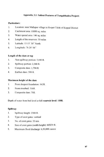
- Page 67 and 68: Secondary data have been collected
- Page 69 and 70: Lowdennilk 1981). Bardhan (1984) an
- Page 71 and 72: attempting to achieve collective be
- Page 73 and 74: External conditions: Physical and t
- Page 75: etc. It is a supply-oriented design
- Page 79 and 80: Chapter 4 Profile of the Sample Vil
- Page 81 and 82: Figure 4.3: Map of Gllndllr Village
- Page 83 and 84: is used to supplement the canal wat
- Page 85 and 86: It is interesting to note that leas
- Page 87 and 88: Table 4.2: Caste-wise Distribution
- Page 89 and 90: more land in the upper and middle r
- Page 91 and 92: than 30 years experience (see Table
- Page 93 and 94: Table 4.12: Distribution of Farmers
- Page 95 and 96: cultivation in the upper and the mi
- Page 97 and 98: Labor shortages are common at peak
- Page 99 and 100: amount of RS.25 but during the year
- Page 101 and 102: majority of the sample fanners are
- Page 103 and 104: I. To introduce a schedule of water
- Page 105 and 106: Rule Enforcement .:. The Associatio
- Page 107 and 108: Chapter 5 Farmers' Knowledge and Pe
- Page 109 and 110: transect walks which revealed that
- Page 111 and 112: consumption which are known to be s
- Page 113 and 114: should be noted that these lands ha
- Page 115 and 116: their lands fully, while some suffe
- Page 117 and 118: management strategies and type of c
- Page 119 and 120: d · 15 degra at IOn . ill Hagedal,
- Page 121 and 122: cropping and intensive irrigation o
- Page 123 and 124: Farmers knowledge of the proposed c
- Page 125 and 126: Reasons for violation In both the v
- Page 127 and 128:
mild waterlogging and were not cult
- Page 129 and 130:
1 0 increasing susceptibility of cr
- Page 131 and 132:
of a water intensive crop. The exce
- Page 133 and 134:
over irrigate their fields. There a
- Page 135 and 136:
depends on the provision of opportu
- Page 137 and 138:
The next most frequently used strat
- Page 139 and 140:
irrigation channels is the responsi
- Page 141 and 142:
the field than needed as insurance
- Page 143 and 144:
of the irrigation fields are kept i
- Page 145 and 146:
In a detailed analysis of the TBP,
- Page 147 and 148:
The most popular practice in Gundur
- Page 149 and 150:
grazing lands and the consequent re
- Page 151 and 152:
do poor quality work. There IS gove
- Page 153 and 154:
the task of organizational and admi
- Page 155 and 156:
have merged the information from bo
- Page 157 and 158:
Three brothers working on leased la
- Page 159 and 160:
everyone individually chooses to ta
- Page 161 and 162:
irrigation officials who exercised
- Page 163 and 164:
water] The local leadership is not
- Page 165 and 166:
Rs. 50 per acre during Rabi to the
- Page 167 and 168:
In afocus group discussion one of t
- Page 169 and 170:
I In Gundur, women are members in t
- Page 171 and 172:
I It can be noted from Table 7.4 th
- Page 173 and 174:
I land and other farmers do not mak
- Page 175 and 176:
• that cattle do not damage the i
- Page 177 and 178:
I the existing situations of their
- Page 179 and 180:
I riding" has become a rational cho
- Page 181 and 182:
I customary nonns. Intangible benef
- Page 183 and 184:
I tennite mounds on fields. They be
- Page 185 and 186:
I Leadership The quality of leaders
- Page 187 and 188:
• One o{the office bearers commen
- Page 189 and 190:
• the causes for waterlogging and
- Page 191 and 192:
• keeping water cess books and bi
- Page 193 and 194:
• through strict rule enforcement
- Page 195 and 196:
• to improve the quality of the W
- Page 197 and 198:
collective management drainage. The
- Page 199 and 200:
PIM initiative did not originate in
- Page 201 and 202:
sustainability could be expected th
- Page 203 and 204:
Chapter 8 Impact of Water Users' As
- Page 205 and 206:
I examines the efficacy of fanners
- Page 207 and 208:
I is 2744.15 kg whereas in Hagedal
- Page 209 and 210:
lands in Gundur is more compared to
- Page 211 and 212:
Table 8.3: Estimated Production Fun
- Page 213 and 214:
decline by 2.5 percent in Gundur an
- Page 215 and 216:
In Gundur, farmers identified crop
- Page 217 and 218:
I Other key problems were the poor
- Page 219 and 220:
• Appendix 8.1: Water Availabilit
- Page 221 and 222:
• Chapter 9 Summary and Conclusio
- Page 223 and 224:
I In Hagedal, one of the sample vil
- Page 225 and 226:
I In irrigated fanning of the fanne
- Page 227 and 228:
I management practices evolved by W
- Page 229 and 230:
• comparable estimates, it would
- Page 231 and 232:
• PIM policy should not just stop
- Page 233 and 234:
References Abbasi~ S. A. 199} .. En
- Page 235 and 236:
Bre~e~·hJ· d S , Kolavalli. A. H.
- Page 237 and 238:
• Dhawan, B. D. 2002. Technologic
- Page 239 and 240:
Gmernment of India. Tenth Five- Yea
- Page 241 and 242:
Joshi. P. K. ,.1987. "Effect of Sur
- Page 243 and 244:
Maloney._ C and K. V. Raju. 1994. '
- Page 245 and 246:
Olson, M. 1965. The Logic of"Collec
- Page 247 and 248:
Reddy, t'vl. Venkata. 1996. "Tungab
- Page 249 and 250:
Sridharan. K. and S. Vedula. 1985.
- Page 251 and 252:
Wade, Robert. 1987 "Ma . '. . . . n