JLR-10 Instruction Manual.pdf - Echomaster Marine Ltd.
JLR-10 Instruction Manual.pdf - Echomaster Marine Ltd.
JLR-10 Instruction Manual.pdf - Echomaster Marine Ltd.
Create successful ePaper yourself
Turn your PDF publications into a flip-book with our unique Google optimized e-Paper software.
<strong>JLR</strong>-<strong>10</strong> GPS Compass<br />
t<br />
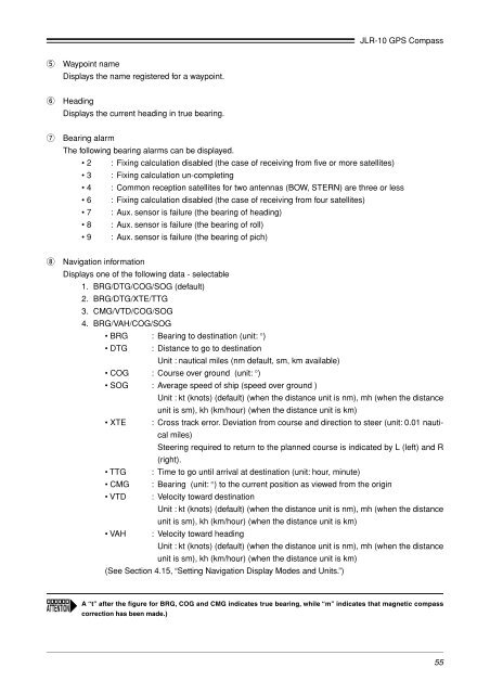
Waypoint name<br />
Displays the name registered for a waypoint.<br />
y<br />
Heading<br />
Displays the current heading in true bearing.<br />
u<br />
Bearing alarm<br />
The following bearing alarms can be displayed.<br />
• 2 : Fixing calculation disabled (the case of receiving from five or more satellites)<br />
• 3 : Fixing calculation un-completing<br />
• 4 : Common reception satellites for two antennas (BOW, STERN) are three or less<br />
• 6 : Fixing calculation disabled (the case of receiving from four satellites)<br />
• 7 : Aux. sensor is failure (the bearing of heading)<br />
• 8 : Aux. sensor is failure (the bearing of roll)<br />
• 9 : Aux. sensor is failure (the bearing of pich)<br />
i<br />
Navigation information<br />
Displays one of the following data - selectable<br />
1. BRG/DTG/COG/SOG (default)<br />
2. BRG/DTG/XTE/TTG<br />
3. CMG/VTD/COG/SOG<br />
4. BRG/VAH/COG/SOG<br />
• BRG : Bearing to destination (unit: °)<br />
• DTG : Distance to go to destination<br />
Unit : nautical miles (nm default, sm, km available)<br />
• COG : Course over ground (unit: °)<br />
• SOG : Average speed of ship (speed over ground )<br />
Unit : kt (knots) (default) (when the distance unit is nm), mh (when the distance<br />
unit is sm), kh (km/hour) (when the distance unit is km)<br />
• XTE : Cross track error. Deviation from course and direction to steer (unit: 0.01 nautical<br />
miles)<br />
Steering required to return to the planned course is indicated by L (left) and R<br />
(right).<br />
• TTG : Time to go until arrival at destination (unit: hour, minute)<br />
• CMG : Bearing (unit: °) to the current position as viewed from the origin<br />
• VTD : Velocity toward destination<br />
Unit : kt (knots) (default) (when the distance unit is nm), mh (when the distance<br />
unit is sm), kh (km/hour) (when the distance unit is km)<br />
• VAH : Velocity toward heading<br />
Unit : kt (knots) (default) (when the distance unit is nm), mh (when the distance<br />
unit is sm), kh (km/hour) (when the distance unit is km)<br />
(See Section 4.15, “Setting Navigation Display Modes and Units.”)<br />
A “t” after the figure for BRG, COG and CMG indicates true bearing, while “m” indicates that magnetic compass<br />
correction has been made.)<br />
55


