JLR-10 Instruction Manual.pdf - Echomaster Marine Ltd.
JLR-10 Instruction Manual.pdf - Echomaster Marine Ltd.
JLR-10 Instruction Manual.pdf - Echomaster Marine Ltd.

You also want an ePaper? Increase the reach of your titles
YUMPU automatically turns print PDFs into web optimized ePapers that Google loves.
<strong>JLR</strong>-<strong>10</strong> GPS Compass<br />
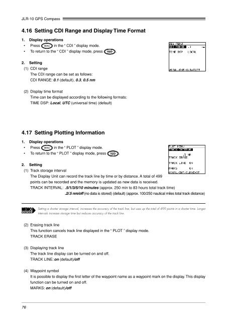
4.16 Setting CDI Range and Display Time Format<br />
1. Display operations<br />
• Press in the “ CDI ” display mode.<br />
• To return to the “ CDI ” display mode, press .<br />
2. Setting<br />
(1) CDI range<br />
The CDI range can be set as follows:<br />
CDI RANGE: 0.1 (default), 0.3, 0.5 nm<br />
(2) Display time format<br />
Time can be displayed according to the following formats:<br />
TIME DSP: Local, UTC (universal time) (default)<br />
4.17 Setting Plotting Information<br />
1. Display operations<br />
• Press in the “ PLOT ” display mode.<br />
• To return to the “ PLOT ” display mode, press .<br />
2. Setting<br />
(1) Track storage interval<br />
The Display Unit can record the track line by time or by distance. A total of 499<br />
points can be recorded and the memory is updated as new data is received.<br />
TRACK INTERVAL: .5/1/3/5/<strong>10</strong> minutes (approx. 250 min to 83 hours total track time)<br />
.2/.5 nm/off (no data is stored) (default) (approx. <strong>10</strong>0/250 nautical miles total track distance)<br />
Setting a shorter storage interval, increases the accuracy of the track line, but uses up the total of 499 points in a shorter time. Longer<br />
intervals increase storage time but reduces accuracy of the track line.<br />
(2) Erasing track line<br />
This function cancels track line displayed in the “ PLOT ” display mode.<br />
TRACK ERASE<br />
(3) Displaying track line<br />
The track line display can be turned on and off.<br />
TRACK LINE:on (default)/off<br />
(4) Waypoint symbol<br />
It is possible to display the first letter of the waypoint name as a waypoint mark on the display. This display<br />
function can be turned on and off.<br />
MARKS: on (default)/off<br />
76