JLR-10 Instruction Manual.pdf - Echomaster Marine Ltd.
JLR-10 Instruction Manual.pdf - Echomaster Marine Ltd.
JLR-10 Instruction Manual.pdf - Echomaster Marine Ltd.

You also want an ePaper? Increase the reach of your titles
YUMPU automatically turns print PDFs into web optimized ePapers that Google loves.
<strong>JLR</strong>-<strong>10</strong> GPS Compass<br />
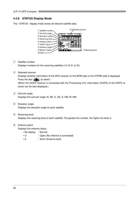
4.5.8 STATUS Display Mode<br />
The “ STATUS ” display mode shows all relevant satellite data.<br />
q Satellite number<br />
e Azimuth angle<br />
r Elevation angle<br />
t Receiving level<br />
y Antenna alarm<br />
u HDOP value<br />
i Antenna height<br />
o Beacon status<br />
!0 Date<br />
w Selected receiver<br />
!1Bearing alarm<br />
q<br />
Satellite number<br />
Displays numbers for the receiving satellites (12 of 01 to 32)<br />
w<br />
Selected receiver<br />
Displays whether information of the GPS receiver on the BOW side or the STERN side is displayed.<br />
Press the dial ( ) to switch.<br />
(When the DGPS receiver is connected with the Processing Unit, information (DGPS) of the DGPS receiver<br />
can be also displayed.)<br />
e<br />
Azimuth angle<br />
Displays the azimuth angle: N, NE, E, SE, S, SW, W, NW<br />
r<br />
Elevation angle<br />
Displays the elevation angle to each satellite.<br />
t<br />
Receiving level<br />
Displays the receiving level of each satellite. The greater the number, the higher the level is.<br />
y<br />
Antenna alarm<br />
Displays the antenna status.<br />
• No display : Normal<br />
• O : Open (No antenna is connected)<br />
• S<br />
: Short (Antenna fault)<br />
62