Floyd County Thoroughfare Plan - Floyd County Indiana - State of ...
Floyd County Thoroughfare Plan - Floyd County Indiana - State of ...
Floyd County Thoroughfare Plan - Floyd County Indiana - State of ...

Create successful ePaper yourself
Turn your PDF publications into a flip-book with our unique Google optimized e-Paper software.
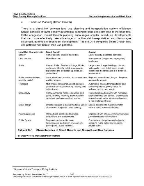
<strong>Floyd</strong> <strong>County</strong>, <strong>Indiana</strong><strong>Floyd</strong> <strong>County</strong> <strong>Thoroughfare</strong> <strong>Plan</strong>Section 5–Implementation and Next Steps4. Land Use <strong>Plan</strong>ning (Smart Growth)There is a direct link between land use planning and transportation system efficiency.Sprawl consists <strong>of</strong> lower-density automobile-dependent land uses that tend to increase totaltraffic congestion. Smart Growth planning encourages smaller mixed-use developmentsthat can more effectively take advantage <strong>of</strong> multimodal transportation, and discouragesdispersed, automobile dependent development. 1 Table 5.04-1 compares Smart Growth landuse patterns and Sprawl land use patterns.Land Use Characteristic Smart Growth SprawlDensity Higher-density, clustered activities. Lower-density, dispersed activities.Land use mix Mixed land use. Homogenous (single-use, segregated)land uses.ScalePublic services (shops,schools, parks)TransportConnectivityStreet designHuman Scale. Smaller buildings, blocks,and roads. Careful detail since peopleexperience the landscape up close, aspedestrians.Local, distributed, smaller. Accommodateswalking access.Multi-modal transportation and land usepatterns that support walking, cycling, andpublic transit.Highly connected roads, sidewalks, andpaths, allowing relatively direct travel bymotorized and nonmotorized modes.Streets designed to accommodate a variety<strong>of</strong> activities, integrated traffic calming.Large scale. Larger buildings, blocks,wide roads. Less detail, since peopleexperience the landscape at a distance,as motorists.Regional, consolidated, larger. Requiresautomobile access.Automobile-oriented transportation andland use patterns, poorly suited forwalking, cycling, and transit.Hierarchical road network with numerousloops and dead-end streets, unconnectedsidewalks and paths, with many barriersto non-motorized travel.Streets designed to maximize motorvehicle traffic volume and speed.<strong>Plan</strong>ning processPublic SpaceTable 5.04-1<strong>Plan</strong>ned and coordinated betweenjurisdictions and stakeholders.Emphasis on the public realm(streetscapes, pedestrian environment,public parks, public facilities).Unplanned with little coordination betweenjurisdictions and stakeholders.Emphasis on the private realm (yards,shopping malls, gated communities,private clubs).Characteristics <strong>of</strong> Smart Growth and Sprawl Land Use PatternsSource: Victoria Transport Policy Institute1 Source: Victoria Transport Policy InstitutePrepared by Strand Associates, Inc. ® 5-13KRH:pll\S:\@SIECO\001--050\046\008\Wrd\<strong>Thoroughfare</strong> <strong>Plan</strong>\Draft 07-19-07\S5-Implementation and Next Steps 07-19-07.doc\072007