Floyd County Thoroughfare Plan - Floyd County Indiana - State of ...
Floyd County Thoroughfare Plan - Floyd County Indiana - State of ...
Floyd County Thoroughfare Plan - Floyd County Indiana - State of ...

You also want an ePaper? Increase the reach of your titles
YUMPU automatically turns print PDFs into web optimized ePapers that Google loves.
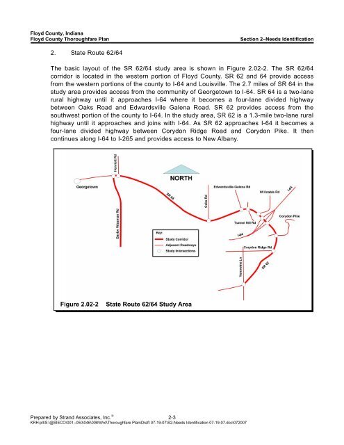
<strong>Floyd</strong> <strong>County</strong>, <strong>Indiana</strong><strong>Floyd</strong> <strong>County</strong> <strong>Thoroughfare</strong> <strong>Plan</strong>Section 2–Needs Identification2. <strong>State</strong> Route 62/64The basic layout <strong>of</strong> the SR 62/64 study area is shown in Figure 2.02-2. The SR 62/64corridor is located in the western portion <strong>of</strong> <strong>Floyd</strong> <strong>County</strong>. SR 62 and 64 provide accessfrom the western portions <strong>of</strong> the county to I-64 and Louisville. The 2.7 miles <strong>of</strong> SR 64 in thestudy area provides access from the community <strong>of</strong> Georgetown to I-64. SR 64 is a two-lanerural highway until it approaches I-64 where it becomes a four-lane divided highwaybetween Oaks Road and Edwardsville Galena Road. SR 62 provides access from thesouthwest portion <strong>of</strong> the county to I-64. In the study area, SR 62 is a 1.3-mile two-lane ruralhighway until it approaches and joins with I-64. As SR 62 approaches I-64 it becomes afour-lane divided highway between Corydon Ridge Road and Corydon Pike. It thencontinues along I-64 to I-265 and provides access to New Albany.Figure 2.02-2<strong>State</strong> Route 62/64 Study AreaPrepared by Strand Associates, Inc. ® 2-3KRH:pll\S:\@SIECO\001--050\046\008\Wrd\<strong>Thoroughfare</strong> <strong>Plan</strong>\Draft 07-19-07\S2-Needs Identification 07-19-07.doc\072007