Floyd County Thoroughfare Plan - Floyd County Indiana - State of ...
Floyd County Thoroughfare Plan - Floyd County Indiana - State of ...
Floyd County Thoroughfare Plan - Floyd County Indiana - State of ...

Create successful ePaper yourself
Turn your PDF publications into a flip-book with our unique Google optimized e-Paper software.
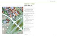
<strong>Floyd</strong> <strong>County</strong>, <strong>Indiana</strong><strong>Floyd</strong> <strong>County</strong> <strong>Thoroughfare</strong> <strong>Plan</strong>Section 4–Alternatives Evaluation4.03 BICYCLE SYSTEM IMPROVEMENTSThe <strong>County</strong> should explore options to incorporate bicycle facilities either as designated bikeroutes, dedicated bike lanes on roads, or <strong>of</strong>f-street multiuse trails. The creation <strong>of</strong> dedicatedbicycle facilities could make bicycle travel a safe and attractive option to motor vehicle travel forshort trips.A. Designated Bicycle FacilitiesDesignated bicycle facilities include the creation <strong>of</strong> bicycle routes that are posted as designatedbike routes throughout the <strong>County</strong>. The actual LOS <strong>of</strong> the facility is to be determined through theBicycle Compatibility Index. Three color coded routes have been identified for the <strong>County</strong> thatwould serve as connectors to four <strong>County</strong> parks. A map <strong>of</strong> the proposed bike routes is shown inFigure 4.03-1, and the routes are described below.1. Red Route–The Red Route is a 20.4 mile route that connects Cannon Acres SoccerFacility to Letty Walters Park on Saint Mary’s Road. The proposed route follow’sQuarry and Old Hill Road to Paoli Pike, and then proceeds for a short distance alongScottsville Road. The route then proceeds along Saint Mary’s Road to Letty WaltersPark. Additional segments for the route have been suggested for the Skyline Drivearea.2. Blue Route–The Blue Route is a 23.4 mile route that connects Letty Walters Park,Greenville Park, and Edwardsville Park. The route meander’s through the northernpart <strong>of</strong> Lafayette and Greenville Township before traveling along Henriott and BaylorWissman Road, in Georgetown Township.3. Yellow Route–The Yellow Route is a 13.4 mile route that connects to the Blue Route.This route proceeds south along Tandy Road to <strong>State</strong> Route 62. Then the routeproceeds along <strong>State</strong> Route 11 to Blunk Knob Road. The route then proceeds eastalong Budd Road and ends at Cannon Acres. The Yellow Route is proposed toconnect to the terminus point <strong>of</strong> the Ohio River Greenway on East 10th Street.Prepared by Strand Associates, Inc. ® 4-44KRH:pll\S:\@SIECO\001--050\046\008\Wrd\<strong>Thoroughfare</strong> <strong>Plan</strong>\Draft 07-19-07\S4-Alternative Evaluation 07-19-07.doc\072007