Floyd County Thoroughfare Plan - Floyd County Indiana - State of ...
Floyd County Thoroughfare Plan - Floyd County Indiana - State of ...
Floyd County Thoroughfare Plan - Floyd County Indiana - State of ...

Create successful ePaper yourself
Turn your PDF publications into a flip-book with our unique Google optimized e-Paper software.
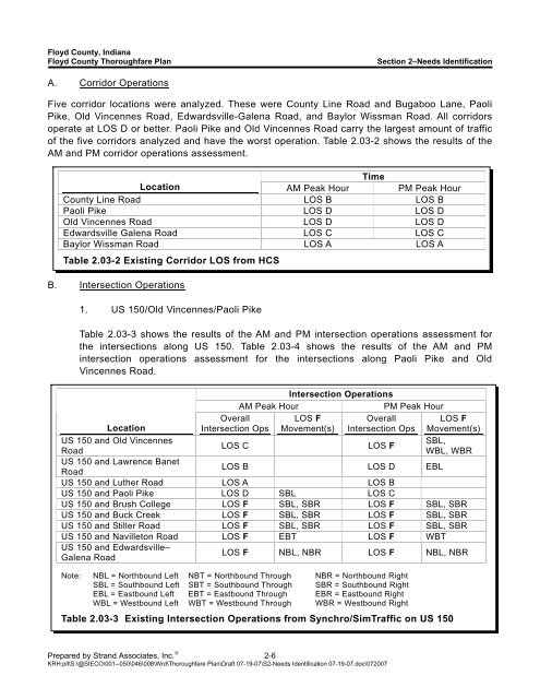
<strong>Floyd</strong> <strong>County</strong>, <strong>Indiana</strong><strong>Floyd</strong> <strong>County</strong> <strong>Thoroughfare</strong> <strong>Plan</strong>Section 2–Needs IdentificationA. Corridor OperationsFive corridor locations were analyzed. These were <strong>County</strong> Line Road and Bugaboo Lane, PaoliPike, Old Vincennes Road, Edwardsville-Galena Road, and Baylor Wissman Road. All corridorsoperate at LOS D or better. Paoli Pike and Old Vincennes Road carry the largest amount <strong>of</strong> traffic<strong>of</strong> the five corridors analyzed and have the worst operation. Table 2.03-2 shows the results <strong>of</strong> theAM and PM corridor operations assessment.TimeLocation AM Peak Hour PM Peak Hour<strong>County</strong> Line Road LOS B LOS BPaoli Pike LOS D LOS DOld Vincennes Road LOS D LOS DEdwardsville Galena Road LOS C LOS CBaylor Wissman Road LOS A LOS ATable 2.03-2 Existing Corridor LOS from HCSB. Intersection Operations1. US 150/Old Vincennes/Paoli PikeTable 2.03-3 shows the results <strong>of</strong> the AM and PM intersection operations assessment forthe intersections along US 150. Table 2.03-4 shows the results <strong>of</strong> the AM and PMintersection operations assessment for the intersections along Paoli Pike and OldVincennes Road.Intersection OperationsAM Peak HourPM Peak HourOverallLOS FOverallLOS FIntersection Ops Movement(s) Intersection Ops Movement(s)LOS CLOS FSBL,WBL, WBRLocationUS 150 and Old VincennesRoadUS 150 and Lawrence BanetRoadLOS B LOS D EBLUS 150 and Luther Road LOS A LOS BUS 150 and Paoli Pike LOS D SBL LOS CUS 150 and Brush College LOS F SBL, SBR LOS F SBL, SBRUS 150 and Buck Creek LOS F SBL, SBR LOS F SBL, SBRUS 150 and Stiller Road LOS F SBL, SBR LOS F SBL, SBRUS 150 and Navilleton Road LOS F EBT LOS F WBTUS 150 and Edwardsville–Galena RoadLOS F NBL, NBR LOS F NBL, NBRNote: NBL = Northbound Left NBT = Northbound Through NBR = Northbound RightSBL = Southbound Left SBT = Southbound Through SBR = Southbound RightEBL = Eastbound Left EBT = Eastbound Through EBR = Eastbound RightWBL = Westbound Left WBT = Westbound Through WBR = Westbound RightTable 2.03-3 Existing Intersection Operations from Synchro/SimTraffic on US 150Prepared by Strand Associates, Inc. ® 2-6KRH:pll\S:\@SIECO\001--050\046\008\Wrd\<strong>Thoroughfare</strong> <strong>Plan</strong>\Draft 07-19-07\S2-Needs Identification 07-19-07.doc\072007