
You also want an ePaper? Increase the reach of your titles
YUMPU automatically turns print PDFs into web optimized ePapers that Google loves.
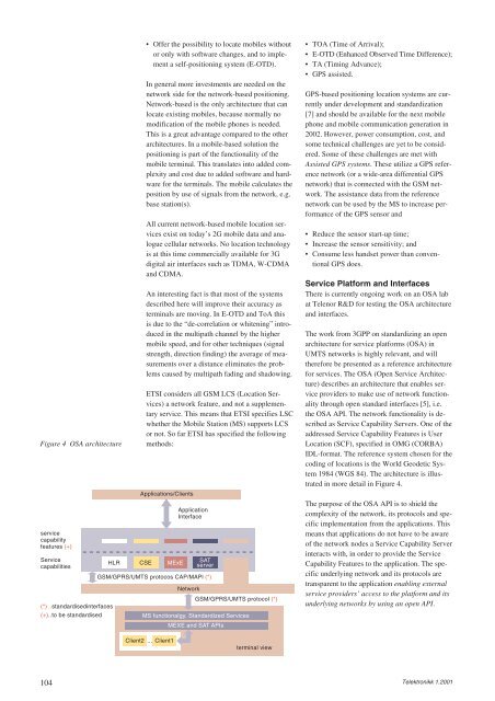
Figure 4 OSA architecture<br />
service<br />
capability<br />
features (+)<br />
Service<br />
capabilities<br />
(*) ..standardisedinterfaces<br />
(+)..to be standardised<br />
104<br />
HLR CSE<br />
• Offer the possibility to locate mobiles without<br />
or only with software changes, and to implement<br />
a self-positioning system (E-OTD).<br />
In general more investments are needed on the<br />
network side for the network-based positioning.<br />
Network-based is the only architecture that can<br />
locate existing mobiles, because normally no<br />
modification of the mobile phones is needed.<br />
This is a great advantage compared to the other<br />
architectures. In a mobile-based solution the<br />
positioning is part of the functionality of the<br />
mobile terminal. This translates into added complexity<br />
and cost due to added software and hardware<br />
for the terminals. The mobile calculates the<br />
position by use of signals from the network, e.g.<br />
base station(s).<br />
All current network-based mobile location services<br />
exist on today’s 2G mobile data and analogue<br />
cellular networks. No location technology<br />
is at this time commercially available for 3G<br />
digital air interfaces such as TDMA, W-CDMA<br />
and CDMA.<br />
An interesting fact is that most of the systems<br />
described here will improve their accuracy as<br />
terminals are moving. In E-OTD and ToA this<br />
is due to the “de-correlation or whitening” introduced<br />
in the multipath channel by the higher<br />
mobile speed, and for other techniques (signal<br />
strength, direction finding) the average of measurements<br />
over a distance eliminates the problems<br />
caused by multipath fading and shadowing.<br />
ETSI considers all GSM LCS (Location Services)<br />
a network feature, and not a supplementary<br />
service. This means that ETSI specifies LSC<br />
whether the Mobile Station (MS) supports LCS<br />
or not. So far ETSI has specified the following<br />
methods:<br />
Applications/Clients<br />
Application<br />
Interface<br />
GSM/GPRS/UMTS protocos CAP/MAPl (*)<br />
GSM/GPRS/UMTS protocol (*)<br />
MS functionalgy, Standardized Services<br />
MEXE and SAT APIs<br />
Client2 ... Client1<br />
MExE<br />
Network<br />
SAT<br />
server<br />
terminal view<br />
• TOA (Time of Arrival);<br />
• E-OTD (Enhanced Observed Time Difference);<br />
• TA (Timing Advance);<br />
• GPS assisted.<br />
GPS-based positioning location systems are currently<br />
under development and standardization<br />
[7] and should be available for the next mobile<br />
phone and mobile communication generation in<br />
2002. However, power consumption, cost, and<br />
some technical challenges are yet to be considered.<br />
Some of these challenges are met with<br />
Assisted GPS systems. These utilize a GPS reference<br />
network (or a wide-area differential GPS<br />
network) that is connected with the GSM network.<br />
The assistance data from the reference<br />
network can be used by the MS to increase performance<br />
of the GPS sensor and<br />
• Reduce the sensor start-up time;<br />
• Increase the sensor sensitivity; and<br />
• Consume less handset power than conventional<br />
GPS does.<br />
Service Platform and Interfaces<br />
There is currently ongoing work on an OSA lab<br />
at <strong>Telenor</strong> R&D for testing the OSA architecture<br />
and interfaces.<br />
The work from 3GPP on standardizing an open<br />
architecture for service platforms (OSA) in<br />
UMTS networks is highly relevant, and will<br />
therefore be presented as a reference architecture<br />
for services. The OSA (Open Service Architecture)<br />
describes an architecture that enables service<br />
providers to make use of network functionality<br />
through open standard interfaces [5], i.e.<br />
the OSA API. The network functionality is described<br />
as Service Capability Servers. One of the<br />
addressed Service Capability Features is User<br />
Location (SCF), specified in OMG (CORBA)<br />
IDL-format. The reference system chosen for the<br />
coding of locations is the World Geodetic System<br />
1984 (WGS 84). The architecture is illustrated<br />
in more detail in Figure 4.<br />
The purpose of the OSA API is to shield the<br />
complexity of the network, its protocols and specific<br />
implementation from the applications. This<br />
means that applications do not have to be aware<br />
of the network nodes a Service Capability Server<br />
interacts with, in order to provide the Service<br />
Capability Features to the application. The specific<br />
underlying network and its protocols are<br />
transparent to the application enabling external<br />
service providers’ access to the platform and its<br />
underlying networks by using an open API.<br />
Telektronikk 1.2001