KONINKLIJKE ACADEMIE VOOR OVERZEESE WETENSCHAPPEN ...
KONINKLIJKE ACADEMIE VOOR OVERZEESE WETENSCHAPPEN ...
KONINKLIJKE ACADEMIE VOOR OVERZEESE WETENSCHAPPEN ...

You also want an ePaper? Increase the reach of your titles
YUMPU automatically turns print PDFs into web optimized ePapers that Google loves.
— 339 —<br />
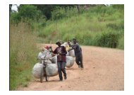
Anyone more or less familiar with the road network inside the country knows<br />
that it suffers from lack of maintenance (fig. 1). Therefore, it was decided to use<br />
(small and large) airstrips (fig. 2), spread out regularly over the working area, for<br />
the installation of the thirty-five concrete pillars. The choice of airstrips guarantees<br />
not only a “free horizon” required for GPS observations, but also a better<br />
chance of survival for the pillars. In some places, where electrical power supply<br />
was available, these points can then later be upgraded to permanent GPS-<br />
stations. The pillars have as dimensions 0.5 x 0.5 x 1 m and are identified by a<br />
label (fig. 3).<br />
Fig. I . — State of the road network.<br />
Fig. 2. — Use of a small airstrip.