- Page 1:
LARGE ANIMALS AND WIDE HORIZONS: AD
- Page 5 and 6:
Chapter 1 Return to Antarctic work:
- Page 7 and 8:
confirmed as permanent and pensiona
- Page 9 and 10:
Raymond Priestley, (renowned as a h
- Page 11 and 12:
especially albatrosses and large nu
- Page 13 and 14:
soon as possible. But first I had t
- Page 15 and 16:
Chapter 2 Antarctic Journey: l970 -
- Page 17 and 18:
island. The tussock was very rough
- Page 19 and 20:
getting off again through the surf.
- Page 21 and 22:
year, but the fog brought duskiness
- Page 23 and 24:
and be exposed to their raucous sho
- Page 25 and 26: were impressive with misty greys, s
- Page 27 and 28: A very fine day followed with Coron
- Page 29 and 30: fish traps and later as boatman to
- Page 31 and 32: one hand and raise my legs to let i
- Page 33 and 34: While Jerry did some more diving, A
- Page 35 and 36: was used on a 350 m nylon rope, run
- Page 37 and 38: Signy and work on the island before
- Page 39 and 40: waves washing over the lower areas.
- Page 41 and 42: I then wrote up the day's results.
- Page 43: were very few suitable haul-out are
- Page 46 and 47: on specific research areas was set
- Page 48 and 49: studies of the seven Antarctic seal
- Page 50 and 51: England), "Za CCCR" (to the USSR) a
- Page 52 and 53: in 1973 the total staff was some 35
- Page 54 and 55: Surprisingly there was opposition w
- Page 56 and 57: accommodation between for my multip
- Page 58 and 59: in Stanley Harbour that evening. Ne
- Page 60 and 61: I went ashore on a fine clear morni
- Page 62 and 63: were swimming around the gemini. At
- Page 64 and 65: Diaz. I was particularly interested
- Page 66 and 67: use Grant's cooling Units and colle
- Page 68 and 69: food store hut and a small general
- Page 70 and 71: Back to the ship at 2.15 pm through
- Page 72 and 73: about 11.30 am I went ashore - or r
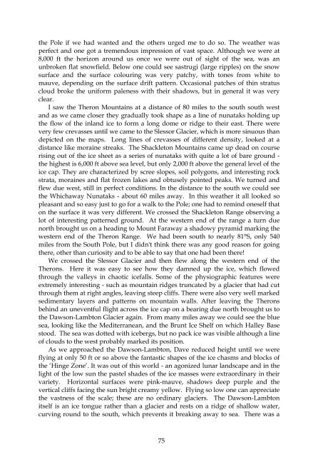
- Page 74 and 75: and some emperors out on the pack.
- Page 78 and 79: were quite different in this respec
- Page 81 and 82: Chapter 6 Continuing Antarctic Jour
- Page 83 and 84: destination, and the sledge parties
- Page 85 and 86: Sound. The melt pools were still fr
- Page 87 and 88: We held a long discussion before an
- Page 89 and 90: the rainbow - a ‘Brocken spectre
- Page 91 and 92: hundreds of tons detached and fell
- Page 93 and 94: we had Mateus Rosé with our dinner
- Page 95 and 96: iology and answering questions unti
- Page 97 and 98: continued spectacular as we approac
- Page 99 and 100: about a mile offshore, where we wer
- Page 101 and 102: swans that flew off. Later seven of
- Page 103 and 104: with the Hopsons and subsequently t
- Page 105 and 106: Chapter 7 Antarctic Journeys: 1975-
- Page 107 and 108: fort, through an entrance gate and
- Page 109 and 110: We called in at the construction of
- Page 111 and 112: more talks with people and then din
- Page 113 and 114: ight sunshine, ploughing through th
- Page 115 and 116: with a dusty band of Fids - they ha
- Page 117 and 118: and spent some time on the bridge.
- Page 119 and 120: people were having to camp on the w
- Page 121 and 122: ship at N9 on Friday, when it saile
- Page 123 and 124: decided not to fly a planned VLF (p
- Page 125 and 126: another geophysics team. They also
- Page 127 and 128:
and we had tea and biscuits with th
- Page 129 and 130:
U. geomorphologists BAS was support
- Page 131 and 132:
interest of science exclam" After d
- Page 133 and 134:
passed a passenger ship Apollon II.
- Page 135 and 136:
also some black-browed albatrosses,
- Page 137 and 138:
ack along the shore. Back at the ho
- Page 139 and 140:
Hilton near the airport. Next day w
- Page 141 and 142:
the region: the marine otter was st
- Page 143 and 144:
decided that the BAS flight uplifti
- Page 145 and 146:
Later another male hauled out near
- Page 147 and 148:
(Nevertheless I think the crabeater
- Page 149 and 150:
and 30 females from mated pairs. Th
- Page 151 and 152:
elephant seals after so long, parti
- Page 153 and 154:
sound, the pulses quite distinct an
- Page 155 and 156:
overcast with a slight to moderate
- Page 157 and 158:
moved up the centre of the strait.
- Page 159 and 160:
weaned Weddell pups. The adult Wedd
- Page 161 and 162:
nevadas - were orange and gold with
- Page 163 and 164:
and Bahia Blanca, arriving at BA ab
- Page 165 and 166:
the community was clearly a happy o
- Page 167 and 168:
at the base with Clive Johnson (GA)
- Page 169 and 170:
upper storey to give a view, to mov
- Page 171 and 172:
my own hair; this has saved me both
- Page 173 and 174:
species; gentoos were disporting in
- Page 175 and 176:
New Year's Eve. We were due to arri
- Page 177 and 178:
dependence experiment (Bill Doidge
- Page 179 and 180:
new Convention on Antarctic Marine
- Page 181 and 182:
15. A case could be made for a surf
- Page 183 and 184:
Serolis went on around the coast, p
- Page 185 and 186:
trail in the sea, the planets Jupit
- Page 187 and 188:
phone call to Harold Bennett (Coron
- Page 189 and 190:
small restaurant - bifé de lomo of
- Page 191 and 192:
Probably the wind was crossing Sign
- Page 193 and 194:
Argentine establishment: rows of re
- Page 195 and 196:
after dinner watched a film "Loopho
- Page 197 and 198:
quality and well-maintained. This t
- Page 199 and 200:
I went ashore next morning to visit
- Page 201 and 202:
Chapter 8 South Georgia and the Fal
- Page 203 and 204:
Harbour. The Caiman was flying the
- Page 205 and 206:
Caiman asked for permission to proc
- Page 207 and 208:
drinks and lunch in his small cabin
- Page 209 and 210:
then received and relayed to the sh
- Page 211 and 212:
which was probably the ship departi
- Page 213 and 214:
British Territory. There was much s
- Page 215 and 216:
of at least one frigate. Two other
- Page 217 and 218:
Before he left the base, he transmi
- Page 219 and 220:
The first real worry came at 21.00
- Page 221 and 222:
Next day, while the British Fleet s
- Page 223 and 224:
forces came over the top to GH. The
- Page 225 and 226:
4. The Military Governor guarantees
- Page 227 and 228:
was to join forces with the RFA Tid
- Page 229 and 230:
y helicopter at Hestesletten and th
- Page 231 and 232:
Chapter 9 After the war, BAS expans
- Page 233 and 234:
this time Kenneth Baker, the Cabine
- Page 235 and 236:
Chapter 10 Antarctic Journey: l983
- Page 237 and 238:
move to UK, but Crown Agents would
- Page 239 and 240:
conditions improved, but still with
- Page 241 and 242:
ship in the scow, climbing aboard a
- Page 243 and 244:
the shelf and the ship would have t
- Page 245 and 246:
they had to be manouevred into posi
- Page 247 and 248:
among large floes with very little
- Page 249 and 250:
The light was good and it was calm.
- Page 251 and 252:
splashing as they porpoised showing
- Page 253 and 254:
were beautiful and the inshore wate
- Page 255 and 256:
Force Officer would collect us at 9
- Page 257 and 258:
Chapter 11 Great waters: The Southe
- Page 259 and 260:
South America it even flows markedl
- Page 261 and 262:
that there has probably been no sig
- Page 263 and 264:
T he unique physics and chemistry o
- Page 265 and 266:
day. This overall pattern is compli
- Page 267 and 268:
vertical water-filled channels and
- Page 269 and 270:
Half the zooplankton biomass in the
- Page 271 and 272:
some of its predators. As described
- Page 273 and 274:
million tons. Although little confi
- Page 275 and 276:
Chapter 12 Last Antarctic Journey a
- Page 277 and 278:
helicopters could not be used or th
- Page 279 and 280:
their creamy feathers accentuated b
- Page 281 and 282:
Oxen, and Jonathan Shanklin's first
- Page 283 and 284:
one skua were the only other birds
- Page 285 and 286:
papers and Nelson was transmitting
- Page 287 and 288:
totally enclosed - no open bridge w
- Page 289 and 290:
hypothesis. It was film night: Jame
- Page 291 and 292:
e made. There could be no guarantee
- Page 293 and 294:
completed (for that visit). Martin
- Page 295 and 296:
‘Sierra’ (tip of the peninsula)
- Page 297 and 298:
winter with everyone pulling their
- Page 299 and 300:
We sailed next morning. I slept, th
- Page 301 and 302:
involved in solving his problems. "
- Page 303 and 304:
Chapter 13 Scientist among Diplomat
- Page 305 and 306:
Consultative Meeting a Recommendati
- Page 307 and 308:
CRAMRA applies to the area south of
- Page 309 and 310:
oth within the system and to the ou
- Page 311 and 312:
Conservation of Antarctic Seals (CC
- Page 313 and 314:
species are killed outside the Anta
- Page 315 and 316:
Comprising about a tenth of the wor
- Page 317 and 318:
much of the arguments relating to t
- Page 319 and 320:
Chapter 14 SCAR: Four Decades of Ac
- Page 321 and 322:
Antarctic which was agreed at the S
- Page 323 and 324:
Advisers; R Fraser and E Herbays we
- Page 325 and 326:
national representatives". A Quater
- Page 327 and 328:
practice this was unworkable becaus
- Page 329 and 330:
Chapter 15 Master of Saint Edmund's
- Page 331 and 332:
forty countries, giving the College
- Page 333 and 334:
clearly separated; that will make p
- Page 335 and 336:
that all in all this would give me
- Page 337 and 338:
students and staff - to do somethin
- Page 339 and 340:
ut a basic practical requirement. H
- Page 341 and 342:
professional performer." "There are
- Page 343 and 344:
claimed, as Bursar, full delegated
- Page 345 and 346:
the Articles (of Associaition) l8 a
- Page 347 and 348:
traumatic arguments of the last few
- Page 349 and 350:
national legislation had superior w
- Page 351 and 352:
ealised that Glazebrook had been th
- Page 353 and 354:
I acknowledged his letter briefly,
- Page 355 and 356:
whether the Master had any authorit
- Page 357 and 358:
On 16 December the Visitor's Solici
- Page 359 and 360:
treatment for a nervous breakdown.
- Page 361 and 362:
September, without saying why. Seco
- Page 363 and 364:
could issue letters of the sort and
- Page 365 and 366:
Committee". The Committee reported
- Page 367 and 368:
On 8 May Holifield wrote to the Fel
- Page 369 and 370:
correspondence and in his celebrate
- Page 371 and 372:
around me the strongest team of off
- Page 373 and 374:
only a good number of my fellow stu
- Page 375 and 376:
the College and for maintaining and
- Page 377 and 378:
members of the catholic heirarchy,
- Page 379 and 380:
Chapter 16 Last Antarctic Journey,
- Page 381 and 382:
Hambledon (formerly Don and Marjori
- Page 383 and 384:
could see the coast on the radar sc
- Page 385 and 386:
electric shock with different patte
- Page 387 and 388:
I wrote until 10.15 am, then went u
- Page 389 and 390:
we should be in Bird Sound c. 4 o
- Page 391 and 392:
The three winterers went out to the
- Page 393 and 394:
What was different was that the ice
- Page 395 and 396:
demonstrate it. It records the ice
- Page 397 and 398:
same stable) was held up in Stanley
- Page 399 and 400:
Publications by RICHARD M. LAWS (Sc
- Page 401 and 402:
for Life. Filmed by C.D.B.Thomas. 1
- Page 403 and 404:
57*. R.M.LAWS 1968c. Dentition and
- Page 405 and 406:
86*. R.M.LAWS, PARKER, I.S.C. and J
- Page 407 and 408:
Antarctic Survey: Annual report, 19
- Page 409 and 410:
137*. R.M.LAWS 1984b. (Editor) Anta
- Page 411 and 412:
163. R.M. LAWS 1986c. Endangered sp
- Page 413 and 414:
190. R.M. LAWS 1989e. A dangerous c
- Page 415 and 416:
219*. R.M. LAWS 1993d. Identificati
- Page 417 and 418:
244. R.M. LAWS l995b. William Nigel
- Page 419:
Short curriculum vitae of Richard M