Fisheries in the Southern Border Zone of Takamanda - Impact ...
Fisheries in the Southern Border Zone of Takamanda - Impact ...
Fisheries in the Southern Border Zone of Takamanda - Impact ...

Create successful ePaper yourself
Turn your PDF publications into a flip-book with our unique Google optimized e-Paper software.
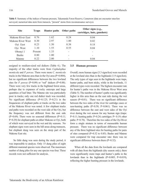
116 Sunderland-Groves and Maisels<br />
Table 5. Summary <strong>of</strong> <strong>the</strong> <strong>in</strong>dices <strong>of</strong> human pressure, <strong>Takamanda</strong> Forest Reserve, Cameroon (data are encounter rates/km<br />
surveyed; numerical data stem from transects, "present" stems from reconnaissance surveys).<br />
Site Traps Hunter paths O<strong>the</strong>r paths<br />
assigned to medium-sized red duikers (Table 4.). The<br />
majority <strong>of</strong> <strong>the</strong> o<strong>the</strong>r tracks were from Cephalophus<br />
monticola and P. porcus. There were more C. monticola<br />
tracks <strong>in</strong> <strong>the</strong> Makone area than <strong>in</strong> <strong>the</strong> Oyi area (P=0.004),<br />
but no significant differences between <strong>the</strong> two lowland<br />
sites for P. porcus (P=0.09) or “red” duikers (P=0.88).<br />
There were very few tracks <strong>in</strong> <strong>the</strong> highland forest areas,<br />
perhaps due to expanses <strong>of</strong> rocky outcrops and large<br />
quantities <strong>of</strong> leaf litter. The Matene site was particularly<br />
poor <strong>in</strong> tracks; only one red duiker track was recorded.<br />
No significant difference (P=0.125; P=0.21) <strong>in</strong> <strong>the</strong><br />
frequencies <strong>of</strong> elephant paths or tracks on <strong>the</strong> two sides<br />
<strong>of</strong> <strong>the</strong> Makone River was noted. A few elephant tracks<br />
and paths were recorded on <strong>the</strong> west side <strong>of</strong> <strong>the</strong> Oyi, but<br />
<strong>the</strong> frequency was not different from <strong>the</strong> east side<br />
(P=0.69). There were no seasonal differences (P=0.11;<br />
P=0.29) for elephant paths at ei<strong>the</strong>r Makone or Oyi, both<br />
<strong>of</strong> which were surveyed <strong>in</strong> <strong>the</strong> wet and dry seasons. No<br />
elephant signs were seen <strong>in</strong> <strong>the</strong> hill areas along transects,<br />
but elephant dung was seen on <strong>the</strong> steep part <strong>of</strong> <strong>the</strong><br />
Makone East site.<br />
So little dung was seen dur<strong>in</strong>g <strong>the</strong> study period, it<br />
was impossible to analyze. Only 15 dung piles <strong>of</strong> eight<br />
different mammal species were observed. The maximum<br />
nunber <strong>of</strong> dung piles for any one species was four. These<br />
records were not sufficient for analysis.<br />
<strong>Takamanda</strong>: <strong>the</strong> Biodiversity <strong>of</strong> an African Ra<strong>in</strong>forest<br />
O<strong>the</strong>r signs (e.g.,<br />
cartridges, huts, gunshots)<br />
Makone River East 0.76 1.62 0.24 0.04<br />
Makone River West 0.30 2.97 1.00 0.02<br />
Oyi East 0.23 1.50 0.38 0.18<br />
Oyi West 1.10 1.55 0.55 0.04<br />
Obonyi 1 Present 1.33 - -<br />
Basho 0.80 1.00 - -<br />
Matene 0.22 2.00 - 0.04<br />
3.5 Human pressure<br />
Overall, more human signs (3.3 signs/km) were recorded<br />
at <strong>the</strong> lowland sites than <strong>in</strong> <strong>the</strong> highlands (1.9 signs/km).<br />
The only types <strong>of</strong> sign seen <strong>in</strong> <strong>the</strong> highlands were traps,<br />
hunter paths, and bent sticks, while <strong>in</strong> <strong>the</strong> lowlands, 11<br />
different types were recorded. The highest encounter rate<br />
for hunter’s paths was <strong>in</strong> <strong>the</strong> Makone River West area<br />
(Table 5). The number <strong>of</strong> hunter’s paths was significantly<br />
higher <strong>in</strong> this area than on <strong>the</strong> east side dur<strong>in</strong>g <strong>the</strong> wet<br />
season (P=0.01). There was no significant difference<br />
between <strong>the</strong> two sides <strong>of</strong> <strong>the</strong> river for cartridge cases or<br />
non-hunt<strong>in</strong>g paths (P=0.58; P=0.061). There was no<br />
difference between <strong>the</strong> east and west sides <strong>of</strong> <strong>the</strong> Oyi<br />
river dur<strong>in</strong>g <strong>the</strong> wet season for any human sign (traps:<br />
P=0.11; hunt<strong>in</strong>g paths: P=0.24; cartridges: P= 0.19; o<strong>the</strong>r<br />
paths: P=0.78). Therefore <strong>the</strong> two sides <strong>of</strong> <strong>the</strong> Oyi River<br />
form a s<strong>in</strong>gle stratum <strong>in</strong> terms <strong>of</strong> measurable human<br />
pressure. There was no significant difference between<br />
any <strong>of</strong> <strong>the</strong> three highland sites for hunt<strong>in</strong>g paths for pairs<br />
<strong>of</strong> sites compared (P=0.32 to 0.85). Basho and Matene<br />
were compared for trap encounter rate: <strong>the</strong>re was no<br />
significant difference between <strong>the</strong>m (P=0.32).<br />
When all <strong>the</strong> data from <strong>the</strong> lowlands are compared<br />
with all data from <strong>the</strong> highlands (dry season only), <strong>the</strong>re<br />
were significantly more traps and hunter’s paths <strong>in</strong> <strong>the</strong><br />
lowlands than <strong>in</strong> <strong>the</strong> highlands (P=0.005; P=0.019),<br />
reflect<strong>in</strong>g <strong>the</strong> higher hunt<strong>in</strong>g pressure <strong>in</strong> <strong>the</strong> lowlands.