EXPLORATIONS IN TURKESTAN
EXPLORATIONS IN TURKESTAN
EXPLORATIONS IN TURKESTAN

Create successful ePaper yourself
Turn your PDF publications into a flip-book with our unique Google optimized e-Paper software.
334<br />
PHYSIOGRAPHY OF CENTRAL-ASIAN DESERTS AND OASES.<br />
him, flat and desolate, is broken here and there by distant towers, mounds, and<br />
citadels, that range far out into the faintly outlined forms which rise and vanish<br />
in mirage.<br />
The most comprehensive point of survey is found on the Erke Tepe, a high knoll<br />
or crumbled tower of Ghiaur Kala's inner walls. This point stands central and<br />
120 feet above the plain, with all the citadels of ancient Merv ranged round for 20<br />
miles. Nearly all are flat-topped plateaus of varied height and length in profile;<br />
but sometimes, as the dust haze clears, far to the north more rounded forms are<br />
seen.<br />
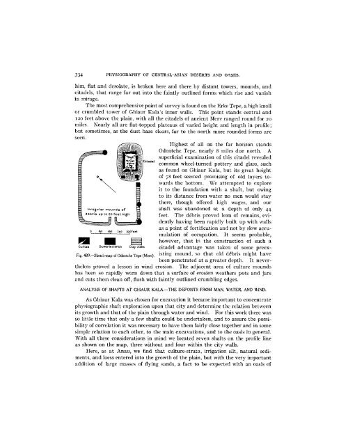
Highest of all on the far horizon stands<br />
Odontche Tepe, nearly 8 miles due north. A<br />
Irregular mounds of<br />
debris up to 20 feet high<br />
0 80 160 240 3o2feet<br />
itadel<br />
superficial examination of this citadel revealed<br />
common wheel-turned pottery and glass, such<br />
as found on Ghiaur Kala, but its great height<br />
of 78 feet seemed promising of old layers towards<br />
the bottom. We attempted to explore<br />
it to the foundation with a shaft, but owing<br />
to its distance from water no men would stay<br />
there, though offered high wages, and our<br />
shaft was abandoned at a depth of only 44<br />
feet. The debris proved lean of remains, evidently<br />
having been rapidly built up with walls<br />
as a point of fortification and not by slow accumulation<br />
of occupation. It seems probable,<br />
however, that in the construction of such a<br />
Gullies Sundried brick Clay walls citadel advantage was taken of some preex-<br />
isting mound, so that old debris might have<br />
Fig. 489.-Sketch-map of Odontche Tepe (Nev)<br />
been penetrated at a greater depth. It nevcrtheless<br />
proved a lesson in wind erosion. The adjacent area of culture mounds<br />
has been so rapidly worn down that a surface of erosion weathers pots and jars<br />
and cuts them clean off, flush with faintly outlined crumbling edges.<br />
ANALYSIS OF SHAFTS AT GHIAUR KALA.-THE DEPOSITS FROM MAN, WATER, AND W<strong>IN</strong>D.<br />
As Ghiaur Kala was chosen for excavation it became important to concentrate<br />
physiographic shaft exploration upon that city and determine the relation between<br />
its growth and that of the plain through water and wind. For this work there was<br />
so little time that only a few shafts could be undertaken, and to assure the possibility<br />
of correlation it was necessary to have them fairly close together and in some<br />
simple relation to each other, to the main excavations, and to the oasis in general.<br />
With all these considerations in mind we located seven shafts on the profile line<br />
as shown on the map, three without and four within the city walls.<br />
Here, as at Anau, we find that culture-strata, irrigation silt, natural sediments,<br />
and loess entered into the growth of the plain, but with the very important<br />
addition of large masses of flying sands, a fact to be expected with an oasis of