EXPLORATIONS IN TURKESTAN
EXPLORATIONS IN TURKESTAN
EXPLORATIONS IN TURKESTAN
Create successful ePaper yourself
Turn your PDF publications into a flip-book with our unique Google optimized e-Paper software.
272<br />
PHYSIOGRAPHY OF CENTRAL-ASIAN DESERTS AND OASES.<br />
These questions arise: What is the explanation of this valley, of which a part<br />
has no trunk-stream? Was it ever a true river-valley? Is it the lower portion<br />
of a valley of which the head-waters have been captured by a higher branch of<br />
the Oxus? Was it possibly the valley of the Kizil Su, now captured at Obu-garm<br />
by the Vaksh River?<br />
East of the open plains the valley-floor has been uplifted and dissected by<br />
the Hyak Darya, which plays the part of a true trunk-stream for that portion.<br />
Following it up to about i8 miles above Faizabad, we find the channel made by<br />
this stream, at first deep with high terraces, decreases in depth and finally opens<br />
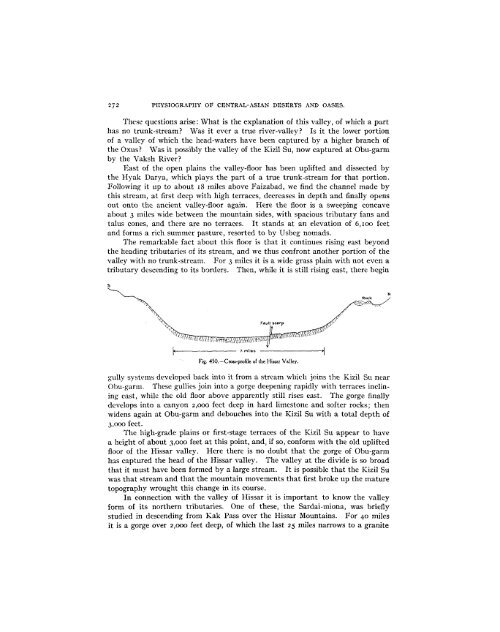
out onto the ancient valley-floor again. Here the floor is a sweeping concave<br />
about 3 miles wide between the mountain sides, with spacious tributary fans and<br />
talus cones, and there are no terraces. It stands at an elevation of 6,1oo feet<br />
and forms a rich summer pasture, resorted to by Usbeg nomads.<br />
The remarkable fact about this floor is that it continues rising east beyond<br />
the heading tributaries of its stream, and we thus confront another portion of the<br />
valley with no trunk-stream. For 3 miles it is a wide grass plain with not even a<br />
tributary descending to its borders. Then, while it is still rising east, there begin<br />
',,. ~ i ,N. · · · ,,<br />
s<br />
1` .^;hP, :1--<br />
Rock<br />
L--------------- 7. miles ------- iteV<br />
Fig. 450.--Cross-profile of the Hissar Valley.<br />
gully systems developed back into it from a stream which joins the Kizil Su near<br />
Obu-garm. These gullies join into a gorge deepening rapidly with terraces inclining<br />
east, while the old floor above apparently still rises east. The gorge finally<br />
develops into a canyon 2,000 feet deep in hard limestone and softer rocks; then<br />
widens again at Obu-garm and debouches into the Kizil Su with a total depth of<br />
3,000 feet.<br />
The high-grade plains or first-stage terraces of the Kizil Su appear to have<br />
a height of about 3,0oo feet at this point, and, if so, conform with the old uplifted<br />
floor of the Hissar valley. Here there is no doubt that the gorge of Obu-garm<br />
has captured the head of the Hissar valley. The valley at the divide is so broad<br />
that it must have been formed by a large stream. It is possible that the Kizil Su<br />
was that stream and that the mountain movements that first broke up the mature<br />
topography wrought this change in its course.<br />
In connection with the valley of Hissar it is important to know the valley<br />
form of its northern tributaries. One of these, the Sardai-miona, was briefly<br />
studied in descending from Kak Pass over the Hissar Mountains. For 40 miles<br />
it is a gorge over 2,000 feet deep, of which the last 25 miles narrows to a granite


