EXPLORATIONS IN TURKESTAN
EXPLORATIONS IN TURKESTAN
EXPLORATIONS IN TURKESTAN

Create successful ePaper yourself
Turn your PDF publications into a flip-book with our unique Google optimized e-Paper software.
DESERTS. 279<br />
short and the base-level aggraded back into the valley again, refilling it with waste.<br />
During this process, and when it had refilled to a height of about 250 feet some<br />
three-quarters of the way upstream, the second-epoch glacier advanced to 45<br />
miles below the present ice front. This ultimate point is near the oasis of Madrushkent.<br />
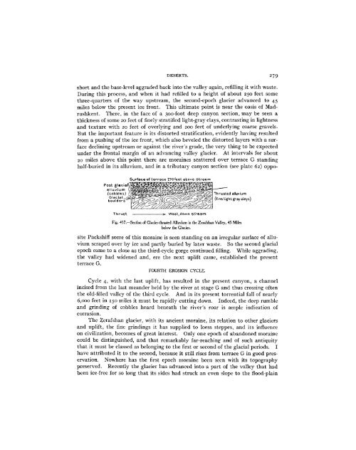
There, in the face of a 300-foot deep canyon section, may be seen a<br />
thickness of some 20 feet of finely stratified light-gray clays, contrasting in lightness<br />
and texture with 20 feet of overlying and 200 feet of underlying coarse gravels.<br />
But the important feature is its distorted stratification, evidently having resulted<br />
from a pushing of the ice front, which also beveled the distorted layers with a surface<br />
declining upstream or against the river's grade, the very thing to be expected<br />
under the frontal margin of an advancing valley glacier. At intervals for about<br />
20 miles above this point there are moraines scattered over terrace G standing<br />
half-buried in its alluvium, and in a tributary canyon section (see plate 62) oppo-<br />
Surface of terrace 270feet above stream<br />
Post glacie<br />
--<br />
a - --<br />
-<br />
alluvium<br />
:<br />
(cobbles) -. ~ - -.~, Thrusted alluvium<br />
oudeGlacial --- ( ffine light gray days)<br />
Thrust -- West,down stream<br />
Fig. 457.-Section of Glacier-thrusted Alluvium in the Zerafshan Valley, 45 Miles<br />
below the Glacier.<br />
site Packshiff some of this moraine is seen standing on an irregular surface of alluvium<br />
scraped over by ice and partly buried by later waste. So the second glacial<br />
epoch came to a close as the third-cycle gorge continued filling. While aggrading,<br />
the valley had widened and, ere the next uplift came, established the present<br />
terrace G.<br />
FOURTH EROSION CYCLE.<br />
Cycle 4, with the last uplift, has resulted in the present canyon, a channel<br />
incised from the last meander held by the river at stage G and thus crossing often<br />
the old-filled valley of the third cycle. And in its present torrential fall of nearly<br />
6,000 feet in 150 miles it must be rapidly cutting down. Indeed, the deep rumble<br />
and grinding of cobbles heard beneath the river's roar is ample indication of<br />
corrasion.<br />
The Zerafshan glacier, with its ancient moraine, its relation to other glaciers<br />
and uplift, the fine grindings it has supplied to loess steppes, and its influence<br />
on civilization, becomes of great interest. Only one epoch of abandoned moraine<br />
could be distinguished, and that remarkably far-reaching and of such antiquity<br />
that it must be classed as belonging to the first or second of the glacial periods. I<br />
have attributed it to the second, because it still rises from terrace G in good preservation.<br />
Nowhere has the first epoch moraine been seen with its topography<br />
preserved. Recently the glacier has advanced into a part of the valley that had<br />
been ice-free for so long that its sides had struck an even slope to the flood-plain