EXPLORATIONS IN TURKESTAN
EXPLORATIONS IN TURKESTAN
EXPLORATIONS IN TURKESTAN

Create successful ePaper yourself
Turn your PDF publications into a flip-book with our unique Google optimized e-Paper software.
282<br />
PHYSIOGRAPHY OF CENTRAL-ASIAN DESERTS AND OASES.<br />
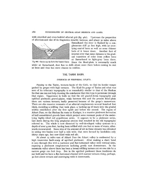
with stratified and cross-bedded alluvial grit (fig. 462). Upstream the proportion<br />
of alluvium and size of its fragments steadily increase, and about 30 miles above<br />
Fig. 460.-Section near the End of the Yarkich Glacier.<br />
Q.o,_-m ln-_ thA r^-r _r-» if flon t1-r - o--<br />
VJUlOicual COI,U C IV1- 1 Il al-lCU Dy t Clulglomerate<br />
cliff 50 feet high, with an overlying<br />
coat of loess as well as some thinner<br />
beds of it lower down. Another fact of<br />
interest over that same distance is the gradual<br />
transition of color from yellow loess<br />
_- 0ct _1idik^dliU U - -l -- 1-___ l-u e.<br />
a:L dc111Ua1 aIlu LU 11gll-glay luess Ulere.<br />
Since the flood-plain is necessarily much<br />
wider at Samarkand, dust has to drift about more there before coming to rest<br />
as loess and thus has more chance to oxidize.<br />
THE TARIM BAS<strong>IN</strong>.<br />
EVIDENCES OF PERIPHERAL UPLIFTS.<br />
Passing to the Tarim, western basin of the Gobi, we find its border ranges<br />
gashed by gorges with high terraces. The Kizil Su gorge of Tarim and what was<br />
seen of its tributary topography is so remarkably similar to that of the Markan<br />
Su that one can not help drawing the conclusion that this type is persistent through<br />
that region. Uppermost in both we find the old graded-down topography and<br />
uplifted piedmont gravel-plains, while between this and the present flood-plain<br />
there are various terraces, badly preserved because of the gorge's narrowness.<br />
There are also massive remnants of an alluvial conglomerate several hundred feet<br />
thick, recording a refilling that took place, a backing-up of waste into the graded<br />
widths established after the first uplift and before the second. The region of<br />
Aikart Pass, on the Markan Su route to Kashgar, is a massive piedmont formation<br />
of half-consolidated gravels from which project some remnant peaks of the underlying<br />
highly-tilted red gypsiferous series. It appears to be a piedmont series,<br />
laid down during the long preglacial erosion that resulted in the old topography<br />
referred to. The whole is now dissected by well-developed valley systems to a<br />
depth of over 4,000 feet, having been refilled with 200 feet or more of waste, afterwards<br />
reexcavated. Some idea of the amount of silt in these streams was obtained<br />
in seeing two basins over half a mile wide, that were formed by landslides only<br />
thirty years ago, but now filled with red silt.<br />
At about 25 miles east of Aikart Pass the Aikart valley is confronted by a<br />
high transverse fault-scarp of uptilted piedmont. After making a short bend<br />
it cuts through this with a narrower and flat-bottomed valley with vertical sides,<br />
exposing a piedmont conglomerate inclining gently east downstream. In the<br />
mountain valley above there has been a broad refilling terrace cut on one side by a<br />
narrow gorge 220 feet deep. But in the uptilted piedmont those traditions do<br />
not hold and we have a flat-bottomed channel with narrow terraces rising, perhaps,<br />
30 feet above stream and converging with it downwards.